02. Core & Settlement Strategy
2.1 Introduction
The Core Strategy and Settlement Strategy for the County Development Plan has been prepared through extensive collaboration between the Forward Planning team, Elected Members and all relevant sections of the Council. It has also been informed by the National Planning Framework (NPF), the Regional Spatial and Economic Strategy (RSES) for the Northern and Western Region, the UN Sustainable Goals and the Strategic Economic Drivers influencing the sustainable future growth of County Mayo over the lifetime of the plan and beyond.
The challenge is to build on the unique dispersed settlement characteristics of Mayo, in order to provide a balance, link and synergy between the rural countryside and urban settlements of the County. This will be realised through the following vision for County Mayo and the strategic aims set out below.
2.2 Vision of County Mayo
‘To create a sustainable and competitive county that supports the health and well-being of the people of Mayo, providing an attractive destination, as a place in which to live, work, invest, do business and visit, offering high quality employment and educational opportunities within strong and vibrant sustainable communities, whilst ensuring a transition to a low carbon and climate resilient county that supports high environmental quality.’
2.3 Strategic Aims
The strategic aims which relate to the advancement of this vision, are set out hereunder for each chapter of Volume 1 of the County Development Plan. The Plan aims to build on previous successes and to strengthen Mayo’s strategic advantage as a county, to ensure that we meet the needs of our citizens, communities, built and natural environments, infrastructure and economic/employment development to their full potential, while combatting and adapting to climate change.
- Housing - To facilitate the sustainable growth of all rural areas, towns, villages and countryside throughout the county by seeking to accommodate, as far as possible, all persons in their choices to live in our rural areas, towns and villages; by supporting and strengthening the rural economy to sustain vibrant rural communities and by promoting consolidation and compact development of all urban and rural settlements in an attractive setting that provides a suitable mix of housing with supporting amenities; and by ensuring coordinated investment in infrastructure that will support economic competitiveness and create a high quality living and working environment.
- Economic Development - To promote and enhance Mayo’s economic development potential through increased resilience in the county’s enterprise, underpinned by talent and innovation, thereby ensuring that Mayo is best placed to excel in the long-term delivery of sustainable jobs and an enhanced standard of living for all.
- Tourism Development - To develop Mayo as a leading tourism destination through continued sustainable expansion of the tourism sector, with a focus on creating high-quality visitor services and the continued development and enhancement of visitor attractions and activities, capitalising on our natural and cultural heritage assets, whilst safeguarding these resources for future generations.
- Movement and Transport - To support increased use of sustainable modes of transport; the integration of spatial planning with transport planning; enhanced county and regional accessibility; the transition to a low carbon energy efficient transport system; and the development of a safer, more efficient, effective and connected transport system within Mayo.
- Strategic Road Network - To maintain the strategic function, capacity and safety of the national roads network, including planning for future capacity enhancements, and to ensure that the existing extensive transport networks, are maintained to a high level to ensure quality levels of service, safety, accessibility and connectivity to transport users.
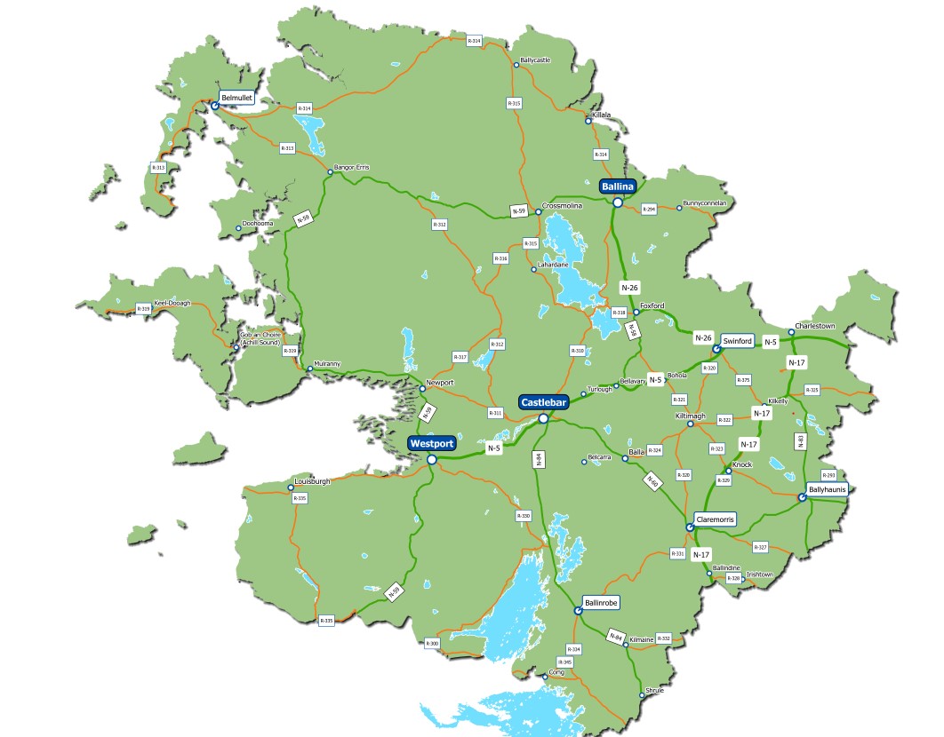
Map 2.1 Strategic Road Network in Mayo
- Infrastructural Development - To protect, improve and provide water, wastewater, surface water and flood alleviation services throughout the county, and to facilitate the provision of high-quality information communication technology, broadband, telecommunication information and electricity network required to support and enhance the key aims of best place to live, work, visit and invest.
- Sustainable Communities - To develop and support vibrant sustainable communities in Mayo where people can live, work and enjoy access to a wide range of community, health, educational facilities and amenities, suitable to all ages and needs, in both urban and rural areas, thereby supporting a high quality of life for all to enjoy.
- Built Environment - To recognise and enhance the unique identity, character and built heritage of Mayo's towns, village and rural areas, to improve quality of life through the application of healthy placemaking, underpinned by good urban design with the creation of attractive public spaces that are vibrant, distinctive, safe and accessible and which promote and facilitate positive social interaction.
- Natural Environment - Continue to protect and enhance the county’s natural heritage and biodiversity and ensure that networks of green and blue infrastructure are identified, created, protected and enhanced to provide a wide range of environmental, social and economic benefits to communities; To also improve the knowledge and understanding of the county’s landscape and coast, and enhance the overall characteristics, qualities and diversity of landscape character, its sense of place and local distinctiveness in recognition of the amenity potential of the county.
- Climate Action and Renewable Energy - To transition to a low carbon and climate resilient county, with an emphasis on reduction in energy demand and greenhouse gas emissions, through a combination of effective mitigation and adaptation responses to climate change; in addition to maximising the opportunities to become a national leader in renewable energy generation, whilst increasing the resilience of our Natural and Cultural Capital to climate change by planning and implementing appropriate adaptation measures.
- Settlements - To develop Mayo's settlements as a network of attractive, liveable towns, villages and countryside in the county with sustainable levels of population, employment activity and enhanced levels of amenity which encourage a high quality of life and well-being and support a sustainable synergy with the rural countryside.
2.4 Cross-Cutting Themes
The following cross-cutting themes also inform the plan:
- Sustainable Communities
- Placemaking
- Social Inclusion
- Regeneration
- Green Infrastructure
- Climate Action
These six-key cross-cutting principles reflect the three pillars of sustainability: Social, Environmental and Economic. The policy context and central objective of this plan is people focussed, recognising that ‘quality of life’ encapsulates strong economic output and stability, good environmental performance and a good standard of living for all, through the creation of healthy, sustainable and attractive places to live, work, invest and visit.
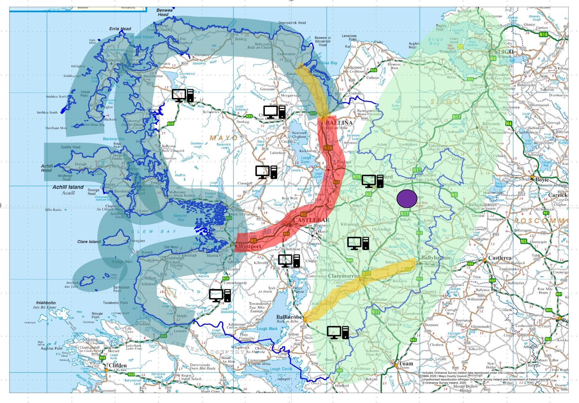
Map 2.2: Strategic Economic Drivers in County Mayo.
2.5 Strategic Economic Drivers with County Mayo
The core and settlement strategies are shaped by the key strategic economic drivers within the county and the wider region. These strategic economic drivers have the potential to drive real transformational change for Mayo, making the county one of the most attractive places to live, work, invest and visit in Ireland. Map 2.2 above illustrates the spatial influence of the strategic economic drivers for County Mayo. The map highlights the influence of the Coastal Corridor to the west and north of the county; the influence of the Atlantic Economic Corridor to the east of the county, including Ireland West Airport Knock and its economic Strategic Development Zone; and the influence of Economic Growth Clusters corridors to the south and through the central reach of the county. The increase of ‘Smarter-working’ options such as remote working and co-working hubs also has real potential to sustain strong and vibrant rural communities throughout the county.
2.5.1 Coastal Zone Corridor
County Mayo has an extensive and varied coastline, which is one of the most valuable and sensitive resources in the county. Coastal areas also support a diverse array of related industries such as fisheries and aquaculture, tourism, shipping and gas industries, which generate enormous economic productivity. The Wild Atlantic Way has also been an important initiative that has showcased how the natural beauty of this landscape has contributed to the economic development of the coastal corridor in recent years. Significant potential exists to harness the marine resources along the County Mayo coastline for recreation and leisure; transport; renewable energy; and appropriate industry. Mayo is strategically located to grow the ‘blue economy’ not only in County Mayo but also at a regional and national level. Economic growth in the marine sector also has the potential to create employment and increase prosperity in all parts of the County, most particularly in coastal communities.
2.5.2 Atlantic Economic Corridor (AEC)
Mayo is strategically located along the Atlantic Economic Corridor (AEC). The AEC aims to combine the economic hubs, clusters and catchments of the area to attract investment, improve competitiveness, support job creation and contribute to an improved quality of life for the people who live there. The AEC has significant potential for future economic growth of/in County Mayo and the wider region. The advancement of Mayo’s economic growth clusters; Ireland West Airport Knock and its Strategic Development Zone; key capital infrastructural projects under Project 2040; and the potential future reopening of the Western Rail Corridor will all consolidate the AEC. The success of the AEC initiative will attract more enterprise and people to the county and the region, progressing balanced regional development, whilst sustaining strong and vibrant communities.
2.5.3 Ireland West Airport Knock (IWAK) and Strategic Development Zone (SDZ)
Ireland West Airport Knock acts as a magnet to draw people and investment to the county and the region, driving economic activity in the form of business and investment as well as tourism and travel. The airport acts as an international gateway to the West of Ireland as well as the North, North-West and Midlands areas. The role of IWAK as a county and regional driver has been further enhanced through the designation of IWAK as an economic Strategic Development Zone (SDZ). The SDZ secures the future development and expansion of the airport and surrounding lands and will form an enterprise and employment hub for the region.
2.5.4 Growth Clusters
The economic development of Mayo will be further enhanced through the development of economic growth clusters for Castlebar-Westport; Ballina and its catchment; and Ballinrobe-Ballyhaunis- Claremorris. These economic growth clusters seek to harness and develop the complementary strengths and synergies between the settlements and their functional hinterland, to create highly connected centres of scale, with the necessary critical mass, in terms of population and employment, to enable them to compete and grow to fulfil their potential and drive regional and national development in tandem with regional and national policy.
2.5.5 Smarter-Working
The growth of digitalisation and the rising accessibility of new technology is having a significant influence on where people live and work. Flexible, smarter-working options such as remote working at home or in a co-working space within a local town or village, will play a critical role in maintaining strong and vibrant rural communities in County Mayo over the plan period and beyond. Such options will retain and attract skilled workers to live, work and invest in Mayo, driving sustainable economic activity, building communities and supporting the transition to a greener economy.
2.5.6 Strategic County Development Plan Objectives
The overarching strategic county development plan objectives, as set out hereunder, are predominantly underpinned by the strategic aims of the Mayo County Development Plan 2022-2028 and the Mayo County Council’s Corporate Plan 2019-2024.
|
Strategic County Development Plan Objectives |
|
|
SO 1 |
Population Growth To plan for a population increase in County Mayo during the plan period of 15,200 persons. |
|
SO 2 |
Quality of Life for Citizens and Communities To promote the well-being and quality of life of all citizens and communities in Mayo and to enhance the attractiveness of the county as a place in which to live, work, visit, invest in and enjoy. |
|
SO 3 |
Employment and Investment To support employment, encourage enterprise, maximise investment and create an environment that will establish Mayo as a premier investment location, capitalising on the county’s existing and emerging key economic drivers, such as the Coastal Corridor and Marine Environment, the Atlantic Economic Corridor, Ireland West Airport Knock (IWAK), the IWAK Strategic Development Zone and the Economic Growth Clusters of Ballina/North Mayo, Castlebar-Westport, Ballinrobe, Ballyhaunis and Claremorris, and Ballina-Killala. |
|
SO 4 |
Low Carbon and Climate Resilient County To transition to a low carbon and climate resilient county, by promoting sustainable settlement patterns, the integration of land-use and sustainable modes of transport, encourage walking, cycling and public transport, increasing reliance on green energy sources, encouraging urban and rural communities to facilitate effective change and by building climate change resilience and climate action into all services and functions of Mayo County Council. |
|
SO 5 |
Development of Sustainable Communities To support and develop sustainable communities and a competitive county that enhances the health and wellbeing of our people and places from rural to urban, with access to employment opportunities, accessibility to high quality housing and physical, social and community infrastructure, including quality transport infrastructure and new digital technologies, where people of all ages can enjoy a good quality of life and a sense of pride in their place. |
|
SO 6 |
Inclusive Society To promote and assist an inclusive county, to ensure that all people of Mayo have access to the range of resources to allow them to fully participate in their local communities, to tackle poverty and social exclusion. |
|
SO 7 |
Protection of Natural and Built Environment To create a sustainable Mayo that protects and enhances the natural and built environment, which underpins Mayo’s unique identity, environmental character and quality of life and also creates a vibrant county that is an attractive destination for business and enterprise, tourists, residents of the county and creative industries alike. |
|
SO 8 |
Supporting Rural Areas To promote the role of Mayo’s rural countryside, by developing a sustainable synergy between the rural area and network of settlements, enhancing the rural economy with improved connectivity, broadband, rural economic development opportunities and smarter working opportunities, all within the context of the sustainable management of land and resources. |
|
SO 9 |
Ecological Impact Assessment, Appropriate Assessment, Strategic Environmental Assessment and Strategic Flood Risk Assessment.
Ensure that proposals for developments located within identified or potential flood risk areas, or which may exacerbate the risk of flooding elsewhere, are assessed in accordance with the provisions of the Flood Risk Management Guidelines (DoEHLG/OPW 2009) and Circular PL2/2014 (or any updated/superseding document), the relevant policies, objectives and guidelines within this plan and shall also take account of the National CFRAM Programme Flood Hazard Mapping and Flood Risk Management Plans when they become available. |
|
SO 10 |
Implementation of National and Regional Objectives To contribute and progress, as practicable, towards achievement of the National Strategic Objectives of Project 2040, the Regional Growth Ambitions of the Northern and Western Regional Assembly’s RSES, and the Sustainable Development Goals of the 2030 Agenda for Sustainable Development. |
|
SO 11 |
Urban Renewal and Regeneration Continue to enhance the towns and villages of County Mayo, through renewal and regeneration, improvements to public realm infrastructure, healthy place-making and by improving the visual amenity, urban design, viability, vibrancy of these areas so that people can live, work and invest in these areas. |
|
SO 12 |
Integrated Land Use and Transportation Planning Integrate land use planning and sustainable transportation planning, promote the consolidation of development, encourage sustainable travel patterns by reducing the need to travel particularly by private transport, while prioritising walking, cycling and public transport.2.7 |
2.7 Core Strategy
The Core Strategy is intended to set out high level policy to direct the future spatial development of County Mayo, consistent with the NPF, RSES and the Planning Acts. Under the Act, a Core Strategy focuses on:
- Defining a settlement hierarchy for the County that is consistent with the NPF and RSES.
- Transposing the prescribed NPF and RSES housing and population targets set at county level for the rural and urban centres identified within the settlement hierarchy.
- Providing an evidence-based rationale for the land proposed to be zoned for residential and mixed-use development, having regard to the capacity of existing zoned land and the phasing of development and taking account of the location of public transport and services.
- Demonstrating how the Planning Authority has had regard to the statutory Retail Planning Guidelines in setting out objectives for retail development.
Mayo is a rural county with a dispersed settlement pattern which is reflective of Mayo’s agrarian history, and which demonstrates the relationship between Mayo people and the rural countryside. The Core Strategy underpins and builds on this rural settlement pattern, whilst strengthening the role played by the towns and villages in establishing a sustainable synergy between both rural and urban areas of the county. The Core Strategy provides a sustainable choice for development between rural and urban areas, increasing the attractiveness of Mayo as a place to live, work, visit and invest.
2.7.1 Population Projections for County Mayo
The Implementation Roadmap for the NPF highlights the Governments focus on achieving alignment between national, regional and local planning policy and practice. The roadmap provides transitional population projections at a regional and county scale, in order to inform Development Plans for the period 2026 and 2031 (Table 2.1). It also sets out mechanisms to assist Development Plans in addressing the six-year period up to 2026/2027.The transitional population projections from the Roadmap for Mayo are listed below:
|
Transitional Population Projections for County Mayo |
||
|
2016 |
2026 |
2031 |
|
130,500 |
142,000-144,500 |
147,000-150,500 |
Table 2.1 Transitional Population Projections for County Mayo
2.7.2 Population Scenarios at Settlement/County Level
Several population growth scenarios were examined in formulating a settlement strategy for Mayo1. The growth scenarios reviewed the key determinants of birth, death and migration rate in the county up to the period 2031, including non-policy-based intervention and policy-based intervention scenarios. The non-intervention scenario does not envisage any policy-based intervention but instead assumes the continuation of the prevailing trends in mortality, fertility and migration. The policy intervention scenario utilises an interpolated forecast of population and assumes a level of policy- based interaction. This scenario was chosen as it aligns with the NPF implementation roadmap population targets. Specifically, the scenario aligns with the NPF projected higher population growth rate for the county, and this is achieved by developing complementary policies and objectives devised to retain 30% of the population that would otherwise migrate out of the county. A central tenet of the chosen scenario is the inclusion of complementary policies and objectives in the plan to enhance the attractiveness of the county for remote working, smarter work practices, and the provision of infrastructure at appropriate locations and scale to facilitate same.
2.7.3 Population Targets for County Mayo
Utilising the policy intervention scenario, which is aimed at reducing migration out of the county and increasing migration into Mayo, the population target for the Plan period to 2027 is set out below in Table 2.2.
|
Population Target for County Mayo |
||
|
2016 |
2027 |
Increase (%) |
|
130,500 |
145,700 |
15,200 (+11.6) |
Table 2.2 Population Targets for County Mayo
The key principle of the Core Strategy is to build on the unique dispersed settlement characteristics of Mayo. In order to provide a balance, link and synergy between the rural countryside and urban settlements of the county, the population ratio between rural and urban will be targeted at 60:40.
|
Target Population Ratio to 2027 Rural:Urban |
||
|
Rural (60%) |
Urban (40%) |
Total (100%) |
|
85,790 |
59,910 |
145,700 |
Table 2.3 Targeted Population Ratio to 2027
2.7.4 Housing Land Requirements
The national and regional NPF Implementation Roadmap population targets account for 50% more growth (headroom) than is required up to 2026/27. Therefore, there is limited further requirement for ‘headroom’ for population growth to be incorporated into statutory development plans in most cases. Projected population growth should be planned in accordance with NPF requirements. These requirements target a minimum of 30% of all new development on infill and brownfield sites within the existing built footprint of urban settlements of over 1,500, with a minimum of 20% of all development on infill and brownfield sites within the existing built footprint of rural settlements. In this regard, lands have only been identified in the Core Strategy for development that can connect to existing development services, i.e. road and footpath access including public lighting, foul sewer drainage, surface water drainage and water supply, for which there is service capacity available, and can therefore accommodate new development. These lands are also positioned within the existing built-up footprint of established settlements or contiguous to existing developed lands.
2.7.5 Average Household Size
The Census 2016 data indicates that Mayo has a population to household size of 2.62, which is lower than the state average of 2.75. However, the NPF states that this state average is expected to decline to around 2.5 by 2040, while also acknowledging that household sizes in urban areas tend to be smaller than in the suburbs or rural parts of the country. In line with this projected trend, a graduated average household size is utilised within this plan to 2040. As shown in the Housing Strategy (Volume 4), in 2027, the average household size is thus projected to be 2.56. By applying the relevant household size to projected population increases, it is possible to forecast required household numbers to 2027 and beyond.
2.7.6 Household Composition
As set out in Section 6.6 of the NPF, information on household composition and projections in relation to household size are informative evidence inputs that can assist with understanding stock profile pressures. Analysis of the historic household sizes (i.e. household size cohort per household from the historic Census data) has therefore been undertaken to help discern and forecast how the composition of households may change during the plan period and is presented in the Housing Strategy (see Volume 4). This analysis (as summarised in Figure 2.1) demonstrates a trend towards 1 and 2 person households over the plan period, which are projected to form a combined total of 62.1% of all households by 2027. In contrast, the number of households comprising of 4 people or more will continue to decline between 2021-2027. Households with four or more people will amount to approximately 22.6% of total households by 2027.
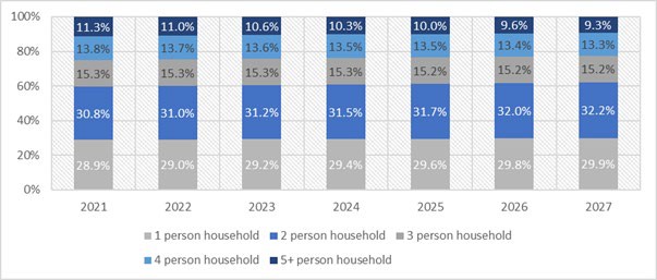
Figure 2.1 Forecasted Household Size Cohort in County Mayo during the plan period (Source: CSO, projected)
2.7.7 Core Strategy Table
The Core Strategy Table as set out below indicates the distribution of future population and housing across the county’s settlements in the form of a settlement hierarchy.
|
Settlement Tiers |
Settlements |
Population 2016 |
Population 2021 |
Population increases to 2028
|
Population Growth Rate %
|
Housing Targets* |
Housing Target Allocation Rate %
|
Quantum of lands zoned Existing Residential |
Quantum of lands zoned for New |
Quantum of lands zoned for Strategic Residential Reserve Tier I |
Quantum of lands zoned for Strategic Residential Reserve Tier II |
|
Tier I (a) Key Towns |
Ballina |
10,171 |
11,160 |
12,348 |
24.4% |
511 |
15.7% |
* |
29.73 |
* |
* |
|
Castlebar |
12,068 |
13,242 |
14,651 |
21.4% |
708 |
21.8% |
* |
36.87 |
* |
* |
|
|
Tier I (b) Strategic Growth Town |
Westport |
6,198 |
6,745 |
7,513 |
21.2% |
285 |
8.8% |
* |
17.13 |
* |
* |
|
Tier II Self-Sustaining Growth Towns |
Ballinrobe |
2,786 |
3,010 |
3,323 |
19.3% |
122 |
3.7% |
66.68 |
13.87 |
19.4 |
30.53 |
|
Ballyhaunis |
2,366 |
2,556 |
2,822 |
19.3% |
71 |
2.2% |
58.68 |
6 |
22.12 |
5.99 |
|
|
Béal an Mhuirthead |
1,019 |
1,101 |
1,215 |
19.3% |
108 |
3.3% |
39.28 |
3 |
15.09 |
N/A |
|
|
Claremorris |
3,687 |
3,984 |
4,397 |
19.3% |
182 |
5.6% |
126.71 |
8.18 |
30.75 |
49.16 |
|
|
Swinford |
1,394 |
1,506 |
1,663 |
19.3% |
68 |
2.1% |
53.76 |
4.48 |
8.79 |
15.31 |
|
|
Tier III Self-Sustaining Towns |
Balla Charlestown Kiltimagh Killala Knock Louisburg Newport Foxford Crossmolina |
7,824 |
8,357
|
8,998 |
15% |
251
|
7.7%
|
N/A |
N/A |
N/A |
N/A |
|
Tier IV Rural Settlements |
18 Settlements* |
4,535 |
4,741 |
4,989 |
10% |
116 |
3.6% |
N/A |
N/A |
N/A |
N/A |
|
Tier V Rural Villages
|
37 Villages* |
2,421 |
2,482 |
2,542 |
5% |
30 |
0.9% |
* |
* |
|
|
|
Total |
52,048 |
56,403 |
64,461 |
23.8% |
2,452 |
75.4% |
|
|
|
|
|
|
Open Countryside |
76,642 |
81,101 |
81,239 |
6% |
800 |
24.6% |
|
|
|
|
|
|
County Total |
130,507 |
137,504 |
145,700 |
11.6% |
3,252 |
100% |
|
|
|
|
|
|
*Note: Statutory Local area plans LAPs to will be prepared for Tier I (a & b) towns. *See Settlement Hierarchy for Tier V Rural Villages |
|||||||||||
Table 2.4 Core Strategy Table
*Note: Statutory Local area plans will be prepared for Tier I towns. Lands zoned for Residential in Tier II towns will be monitored to ensure the delivery of the proposed housing targets. Upon reaching the new residential unit target per settlement, the remaining undeveloped residential lands will revert to strategic residential reserve lands. Tiers III, IV and V adopt a single category mixed-used zoning approach.
2.7.8 Retail Strategy
The Mayo County Development Plan recognises a four-tier retail hierarchy in the county (See Table 2.5 below). This retail hierarchy is consistent with the RSES (2020-2020), Section 28 Retail Planning Guidelines (2012) and the Settlement Strategy and aims to concentrate higher order shopping functions in Castlebar, Ballina and Westport. The sequential approach to development will be applied to proposals for retail development in accordance with the Retail Planning Guidelines for Planning Authorities (DoEHLG 2012). The land use maps for Tiers I to III, inclusive, identifies inner (town centre) and outer (edge of town centre) town centre areas to assist in the applicable of the sequential approach, whilst ensuring edge of-centre sites are within easy walking distance of the identified primary retail area of each town.
|
Tiers |
Town |
RPGs Retail Hierarchy Tiers |
|
Tier I(a) – Key Towns |
Ballina and Castlebar |
Regional (Tier 2) |
|
Tier I(b) – Strategic Growth Centre |
Westport |
Sub-Regional/District Centre (Tier 3) |
|
Tier II – Self-Sustaining Growth Centres |
Ballinrobe, Ballyhaunis, Belmullet, Claremorris and Swinford |
Small Towns and Rural Areas (Tier 4) |
|
Tier III – Self-Sustaining Growth Centres |
Balla, Charlestown Crossmolina, Foxford, Knock, Killala, Kiltimagh, Louisburgh and Newport. |
Small Towns and Rural Areas (Tier 4) |
|
Tier IV – Rural Settlements |
18 no. Rural Settlements |
Local Shopping (Tier 5) |
|
Tier V – Rural Villages |
37 no. Rural Villages |
Local Shopping (Tier 5) |
Table 2.5 - Retail Hierarchy
2.7.9 Monitoring and Management
With the adoption of specific population targets for the county and each settlement/tier typology, the monitoring of the extent of residential development is required to ensure that development occurs in a coherent, reasoned and evidence-based manner. Notwithstanding that the population increase/household allocations are targets and not limits the delivery of all residential development will be carefully monitored during the lifetime of this Plan to ensure it does not cumulatively result in housing units or population being exceeded within the context of the overall population limits within the county and in accordance with the Core Strategy and S28 Housing Target Guidelines. Where individual settlements are considered unlikely to reach their dwelling unit target within the lifetime of the plan the housing allocation may, if required, be utilised elsewhere within the Core Strategy provided that the overall development allocation for the county is not exceeded.
2.7.10 Core Strategy Policies and Objectives
Mayo County Council shall ensure that the future spatial development of Mayo is informed by means of a plan led approach, directing residential and employment generating development to locations in accordance with national and regional policy, and with environmental carrying capacity, which can support investment in public infrastructure and services, and which is sensitive to the physical character of the built and natural environment. This approach is enshrined in a number of Core Strategy Policy Objectives, as set out below.
|
Core Strategy Policies |
|
|
CSP 1 |
To promote and facilitate the development of all communities in the County. |
|
CSP 2 |
To promote measures to reduce vacancy and the underuse of existing building stock and support initiatives that promote the reuse, refurbishment and retrofitting of existing buildings within all settlements in the Settlement Hierarchy and the rural countryside. |
|
CSP 3 |
To support the growth of towns and villages and open countryside to ensure that development proceeds sustainably and at an appropriate scale. |
|
CSP 4 |
Where individual settlements are considered unlikely to reach their dwelling unit target within the lifetime of the plan the housing allocation may, if required, be utilised elsewhere within the Core Strategy provided that the overall development allocation for the county is not exceeded. |
|
CSP 5 |
It is a Policy of the Council to examine the feasibility and where practical, seek to facilitate serviced sites on council acquired land, at affordable prices within the footprint of existing settlements, predominantly aimed at Tier II and Tier III settlements. These serviced sites would be developed, and master planned by Mayo County Council and made available for sale to persons who meet a defined range of criteria to be established in consultation with the Housing SPC and/or national guidelines. |
|
CSP 6 |
Where individual settlements are considered unlikely to reach their dwelling unit target within the lifetime of the plan the housing allocation may, if required, be utilised elsewhere within the Core Strategy provided that the overall development allocation for the county is not exceeded. |
|
Core Strategy Objectives |
|
|
CSO 1 |
To secure the implementation of the population and housing growth household allocation set out in the Core Strategy and Settlement Strategy, in so far as practicable, by facilitating rural housing, while allowing for the accommodation of further residential growth in our designated settlements, subject to the availability of infrastructure and services. |
|
CSO 2 |
To ensure that sufficient zoned lands are available to satisfy the housing requirements of the designated settlements in the county over the lifetime of the Plan. |
|
CSO 3 |
To adopt Local Area Plans for Ballina, Castlebar and Westport that align with the NPF, RSES and this Core Strategy. During the transition period between adoption of this County Development Plan and the adoption of the Local Area Plans for Ballina, Castlebar and Westport, the objectives (including zoning objectives), policies and standards in this County Development Plan shall apply to these towns. |
|
CSO 4 |
To move towards more compact towns by promoting the development of infill and brownfield/consolidation/regeneration sites, where available, and the redevelopment of under-utilised land within and close to the existing built-up footprint of existing settlements as an alternative to edge of centre locations. |
|
CSO 5 |
To encourage where possible the delivery of 30% of new homes in urban areas within the existing built-up footprint of settlement. |
|
CSO 6 |
To deliver at least 20% of all new homes in the rural area on suitable brownfield sites, including rural towns, villages and the open countryside. For the purpose of clarity, rural towns/villages are settlements with population levels less than 1,500 persons. |
|
CSO 7 |
To monitor and maintain a record of residential development permitted in settlements designated under the Settlement Hierarchy in accordance with any Departmental guidance that may arise. |
2.8 Settlement Strategy
The settlement strategy will continue to provide for the sustainable development of the county by continuing to balance the distribution of Mayo’s population between rural to urban.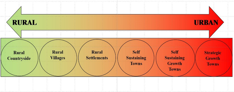
Figure 2.2: Synergy Between Rural and Urban through Settlement Hierarchy
2.8.1 Settlement Hierarchy
County Mayo has traditionally been a predominantly rural county and for this reason the Core and Settlement Strategy separates the rural countryside from settlements in the Settlement Hierarchy. The allocation of the settlements within each tier of the settlement hierarchy was informed by:
- NPF and RSES
- Population Size
- Settlement Asset Capacity Matrix (Appendix I).
- Ratio of Jobs to Worker Ratio
This approach ensures that settlements identified for significant population and/or employment growth are supported by the requisite investment in infrastructure and provision of employment opportunities, amenities and services.
Settlement Hierarchy for County Mayo (Table 2.6).
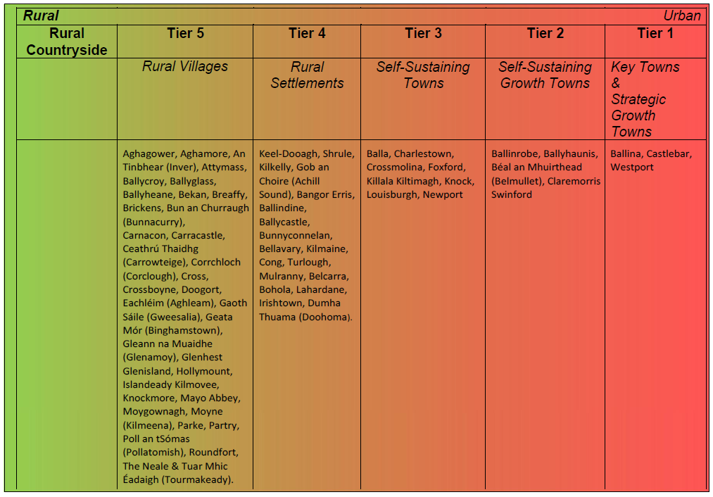
Settlement Hierarchy for County Mayo
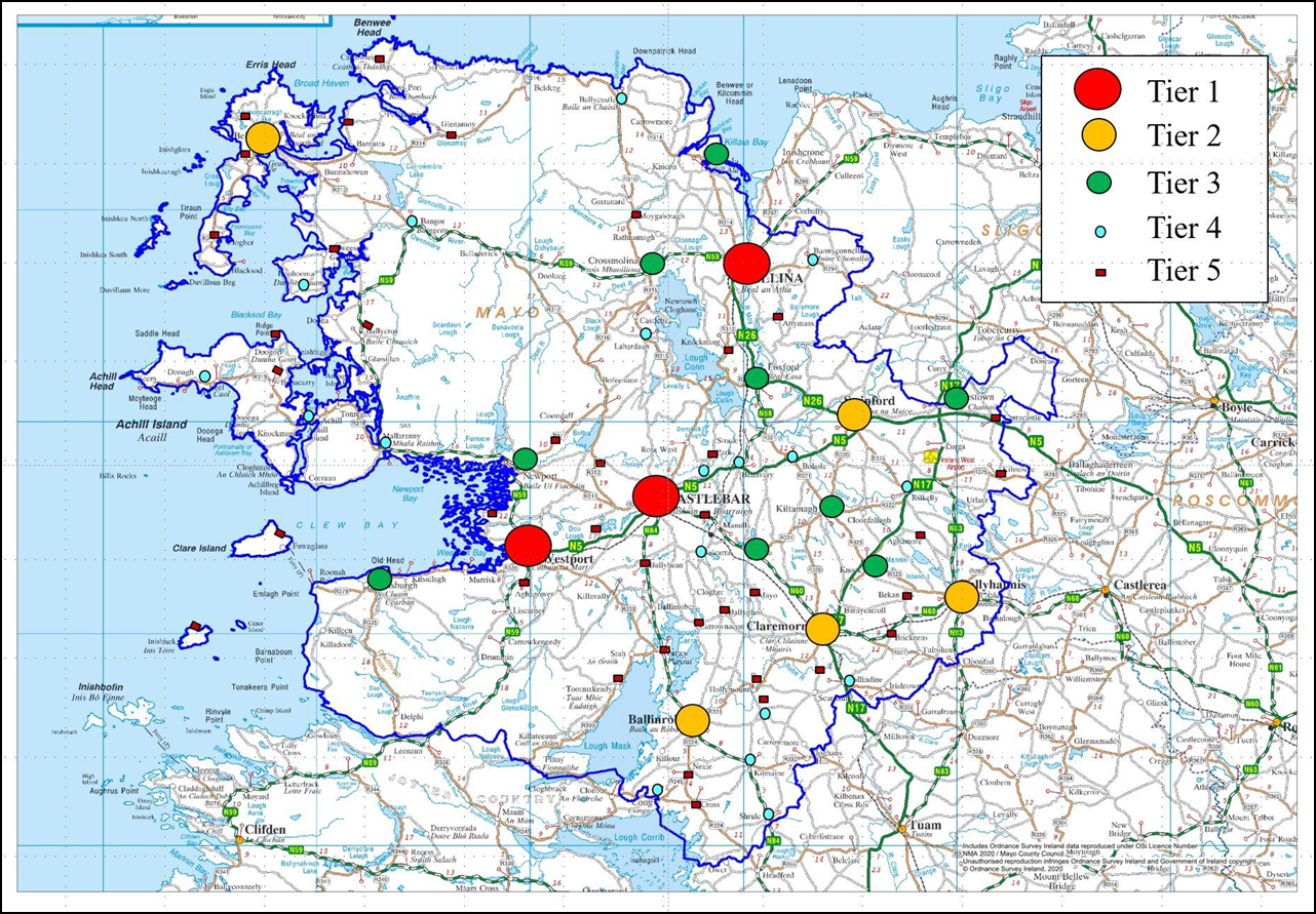
Map 2.3 Settlement Hierarchy Map
2.8.1.1 Rural Countryside
The rural countryside is and will continue to be a living and lived-in landscape focusing on the requirements of rural economies and communities, while at the same time avoiding inappropriate development from urban areas and protecting environmental assets. The Council will ensure that development of the unserviced rural areas takes place in a manner that is compatible with the protection of key economic, environmental, biodiversity and cultural/heritage assets such as the road network, water quality and important landscapes.
2.8.1.2 Rural Villages (Tier V)
Rural Villages in the Settlement Strategy comprises of small villages, of less than 50 people.
|
Aghagower, Aghamore, An Tinbhear (Inver), Attymass, Ballycroy, Ballyglass, Ballyheane, Bekan, Breaffy, Brickens, Bun an Churraigh (Bunnacurry), Carnacon, Carracastle, Ceathrú Thaidhg (Carrowteige), Corrchloch (Corclough), Cross, Crossboyne, Doogort, Eachléim (Aghleam), Gaoth Sáile (Gweesalia), Geata Mór (Binghamstown), Gleann na Muaidhe (Glenamoy), Glenhest, Glenisland, Hollymount, Islandeady Kilmovee, Knockmore, Mayo Abbey, Moygownagh, Moyne (Kilmeena), Parke, Partry, Poll an tSómas (Pollatomish), Roundfort, The Neale & Tuar Mhic Éadaigh (Tourmakeady). |
There is considerable variation in the villages included in this tier in terms of scale, character, context, and infrastructure. However, all have potential for appropriate levels of growth and consolidation. In order to realise the consolidation of these villages, each Rural Village Plan defines the village boundary and encourages development to be delivered in a sustainable, sequential manner from the village core outwards, while promoting the reuse and redevelopment of vacant and derelict sites and buildings. A single category mixed-use zoning applies to the rural village plans i.e. Rural Village Consolidation Zoning. A similar approach is adopted for Tier IV Rural Settlement Plans. These rural villages provide a choice for those who wish to live in a rural setting but not in the rural countryside.
2.8.1.2 Rural Settlements (Tier IV
|
Keel-Dooagh, Shrule, Kilkelly, Gob An Choire (Achill Sound), Bangor Erris, Ballindine, Ballycastle, Bellavary, Bunnyconnelan, Kilmaine, Cong, Turlough, Mulranny, Belcarra, Bohola, Lahardane, Irishtown and Dumha Thuama (Doohoma). |
Tier IV of this Core Strategy contains serviced rural towns and villages with populations of greater than 50 but less than 500, which function as local service and employment providers. In these settlements, defined land use areas can be identified (e.g. town centre, residential etc.) and a broader range of services, functions and employment opportunities are generally provided. All settlements in this tier are serviced by Irish Water infrastructure.
In order to realise the consolidation of these villages, each Rural Settlement Plan defines the village boundary and encourages development to be delivered in a sustainable sequential manner from the village core outwards, while promoting the reuse and redevelopment of vacant and derelict sites and buildings. A single category mixed-use zoning applies to the rural settlement plans i.e. Rural Settlement Consolidation Zoning. Facilitating population growth through the provision of housing of suitable scale and character in these villages, subject to availability of services, is considered paramount to ensuring their future vitality and viability. The availability of serviced sites, in tandem with schemes such as the Irish Water Scheme for Small Towns and Villages, will further help to achieve this objective.
2.8.4.1 Self-Sustaining Towns (Tier III)
|
Crossmolina, Foxford, Balla, Killala, Knock, Kiltimagh, Louisburg, Newport and Charlestown. |
Self-Sustaining Towns have moderate levels of population growth and a limited localised employment base, are reliant on other areas for employment and/or services and therefore require targeted ‘catch up’ investment to become more self-sustaining. While some of the settlements in this tier have populations similar to that of a number of settlements in Tier II, the employment base and asset capacity in the Tier III settlements need to be firstly increased, as opposed to targeting them for larger population allocations at this juncture.
In order to reflect this more measured approach to development within Self-Sustaining Towns, the aggregate population increase for all of the settlements in this tier is accumulated and each settlement plan adopts a more flexible zoning approach, within a defined settlement boundary. A single category mixed-use zoning applies to Tier III Self-Sustaining Towns i.e. Self-Sustaining Consolidation Zoning. This approach is also underpinned by the identification of opportunity sites within each settlement and objectives designed to ensure that future developments are of a suitable scale and nature, consolidate the town core and demonstrate the use of the “good neighbour” principle and the sequential approach at all times.
2.8.1.5 Self-Sustaining Growth Towns (Tier II)
|
Claremorris, Ballyhaunis, Ballinrobe, Swinford and Béal an Mhuirthead |
The towns included in Tier II of the settlement strategy are described as Self-Sustaining Growth Towns. These are towns with a moderate level of jobs and services with capacity for continued commensurate growth, in order to become more self-sustaining. Three of the towns included in Tier II, Claremorris, Ballyhaunis and Ballinrobe have existing populations over 1,500, while the towns of Swinford and Béal an Mhuirthead, with populations of 1,394 and 1,019 respectively, are also included. All Tier II towns have jobs to workers ratio of close to 1 or above, with Swinford and Béal an Mhuirthead having jobs to workers ratio of 2.332 and 1.735 respectively, this indicates that a significant number of workers commute to each settlement from their labour catchments. All towns in this tier are also included based on the social, economic, and natural assets identified in each when assessed using the Settlement Asset Capacity (Appendix I), which would indicate their capacity to accommodate larger population allocations in comparison to Tier III towns.
On an individual level, it is considered that Swinford also merits inclusion based on its strategic location on the N5, along the Atlantic Economic Corridor and in close proximity to Ireland West Airport Knock and the Key Towns of Ballina and Castlebar. Béal an Mhuirthead also merits inclusion being an important Gaeltacht Service Town along the Coastal Zone and Wild Atlantic Way. This town plays a key role in the delivering services and supporting employment for the northwest region of Mayo which is at a remove from other growth towns.
A conventional land-use zoning approach has been adopted for Tier II Self-Sustaining Growth Towns, with Town Centre Opportunity Sites identified in town centre areas to encourage town centre consolidation and revitalisation.
2.8.1.6 Key Towns and Strategic Growth Towns (Tier I (a) and Tier I (b))
|
Ballina, Castlebar and Westport |
The towns included in Tier I of the settlement strategy are described as Tier 1 (a) Key Towns and Tier I (b) Strategic Growth Town. These towns are the main urban centres of scale in the county. The RSES designates Castlebar and Ballina as Key Towns. Key Towns are defined as regionally, strategic employment centres of significant scale that can act as regional drivers that complement and support the higher-order urban areas within the settlement hierarchy.
Westport, a Strategic Growth Town in the settlement hierarchy, is identified in the RSES as an urban centre with strategic development potential which seeks to build on the strong physical, economic and social intrinsic links with Castlebar. The future growth of Castlebar and Westport is best achieved by building on these intrinsic links to grow in tandem as a driver of economic development for the county and region.
Ballina
Ballina has a population of 10,171 (CSO 2016) and is the second largest town in Mayo. Ballina functions as the main economic driver for a large area of north Mayo. The town provides 4,810 jobs, with a jobs/resident worker ratio of 1.361 (CSO 2016). Due to its proximity to County Sligo, the town also serves as the main economic, commercial and social/educational centre for parts of west Sligo. This influence, in turn, overlaps with the western sphere of influence of the regional growth centre of Sligo town. This juxtaposition highlights Ballina’s current and future role, both as a stand-alone economic driver and an integral part of the network of other key population centres and economic drivers along this section of the AEC.
Castlebar
Castlebar has a population of 12,068 (CSO 2016) and is the largest town in Mayo. Castlebar is the main administrative, public health, education and commercial centre in the county. The town provides over 9000 jobs, with a jobs/resident worker ratio of 1.920 (CSO 2016). Castlebar, at a more strategic level, is intrinsically linked to the nearby town of Westport and the imminent upgrading of the N5 will also reduce the commuting time between Westport and Castlebar.
Westport
Westport has a population of 6,198 (CSO 2016) and is the third largest town in Mayo. Westport provides important administrative, service and economic roles and functions to its hinterland and has a reputation as being one of Ireland’s premier visitor destinations. The town provides 4,142 jobs, with a jobs/resident worker ratio of 1.647 (CSO 2016). Westport’s large industrial base, its enterprise economy and vibrant tourism industry, as well as its potential marine resources, justifies its inclusion in the top tier of the Settlement Strategy for the county as a linked growth driver with Castlebar.
|
Settlement Strategy Policies |
|
|
SSP 1 |
Support the appropriate growth of the Rural Countryside by offering a sustainable choice for people to live in order to maintain vibrant Rural Communities. |
|
SSP 2 |
Support the continued growth and sustainable development of Ballina, Castlebar and Westport, as designated Tier I towns (Key Towns and Strategic Growth Town) in the Settlement Strategy, capitalising on Ballina’s designation as a Key Town in the context of the Sligo Regional Growth Centre and Castlebar/Westport as a linked growth driver in the region. |
|
SSP 3 |
Promote consolidation in Self-Sustaining Growth Towns coupled with targeted investment where required, to improve local employment, services and sustainable transport options and to become more self-sustaining settlements. |
|
SSP 4 |
Promote commensurate population and employment growth in the designated Self-Sustaining Towns, providing for natural increases and to become more economically self-sustaining, in line with the quality and capacity of public transport, services and infrastructure available. |
|
SSP 5 |
To promote and encourage the sustainable, balanced development of the Rural Settlements and Rural Villages in an incremental manner, with the emphasis on small scale development over a medium to long-term period, in keeping with the character of the settlement. |
|
SSP 6 |
To support the creation of healthy and sustainable communities that encourages and facilitates walking and cycling and general physical activity through the implementation of best practices in urban design that promotes permeability and interconnecting spaces. |
|
SSP 7 |
To promote the integration of land use and transportation policies and to prioritise provision for cycling and walking travel modes and the strengthening of public transport. |
|
SSP 8 |
To develop the county in accordance with the Settlement Hierarchy and to require future residential development to locate at and be of a scale appropriate to the settlement tiers and levels identified in the Core Strategy Table, subject to the availability of infrastructure and services. |
|
Settlement Strategy Objectives |
|
|
SSO 1 |
To promote rural sustainability by facilitating appropriate growth of the rural countryside by facilitating those who comply with our rural housing policy. |
|
SSO 2 |
To facilitate the development of Ballina, Castlebar and Westport to underpin their role as designated Tier I Key Towns and a Strategic Growth Town, respectively, in the Settlement Hierarchy and to ensure that the growth of these towns takes place in an orderly and sustainable fashion that will not detract from the vitality and viability of their town centres. |
|
SSO 3 |
To require sustainable, compact, sequential growth and urban regeneration in Ballina, Castlebar and Westport by consolidating the built-up footprints of these towns through a focus on regeneration and development of town centre infill and brownfield sites, and encouraging regeneration of underutilised, vacant and derelict lands for residential development and mixed use to facilitate population growth. |
|
SSO 4 |
To apply higher densities to the higher order settlements of Ballina, Castlebar and Westport (see DM Standards), to align with their roles within the settlement hierarchy, subject to good design and development management standards being met. |
|
SSO 5 |
To apply graded densities in towns and villages having regard to their role in the Settlement Hierarchy and where they are commensurate to the existing built environment. |
|
SSO 6 |
To strengthen the core of settlements and encourage the compact growth of settlements by way of the development of infill sites, brownfield lands, under- utilised land / buildings, vacant sites, and derelict sites within the existing built-up footprint of the settlements and develop outwards from the centre in a sequential manner. |
|
SSO 7 |
To promote measures to reduce vacancy and the underuse of existing building stock and support initiatives that promote the reuse, refurbishment and retrofitting of existing buildings and the regeneration of under-utilised lands within all settlements in the Settlement Hierarchy and the rural countryside. |
|
SSO 8 |
To ensure that settlements grow in a manner that is self-sustaining with sufficient social and economic infrastructure, and to a scale which aligns with the Settlement Hierarchy prescribed in the Core Strategy. |
|
SSO 9 |
To ensure that all applications for retail developments are appropriate to the retail role, function and capacity of settlements within the settlement hierarchy and County Retail Hierarchy (Table 2.5) and have regard to the Retail Planning Guidelines for Planning Authorities (DoEHLG 2012, as amended or superseded). |
|
SSO 10 |
To support and facilitate the delivery of consolidation and targeted ‘catch up’ investment in services, infrastructure, amenities and local employment to settlements, where appropriate. |
|
SSO 11 |
To seek to progress the list of Municipal District Projects over the plan period, as set out in Appendix II. |
|
SSO 12 |
To ensure the promotion of sustainable settlement and transportation strategies in urban and rural areas including the promotion of measures to— (i) reduce energy demand in response to the likelihood of increases in energy and other costs due to long-term decline in non-renewable resources, (ii) reduce anthropogenic greenhouse gas emissions, and (iii) address the necessity of adaptation to climate change; in particular, having regard to location, layout and design of new development. |
|
SSO 13 |
The land use zoning provisions of the existing town and environs development plans for Ballina, Castlebar and Westport shall continue to be implemented on an interim basis until such time as local area plans are adopted for these towns, whilst also having regard to any draft local area plan, and subject to compliance with the provisions of the Mayo County Development Plan, including the Core Strategy population/housing targets. |
|
SSO 14 |
Development proposals in Ballina, Castlebar and Westport shall be assessed on an interim basis taking account of the principles of proper planning and sustainable development inter alia traffic safety, residential amenity, flood risk, cultural, natural and built heritage, and in accordance with the provisions of the Mayo County Development Plan, including the Core Strategy population/housing targets. |
|
SSO 15 |
To support and facilitate the achievement of the key priorities identified for the Key Towns of Ballina and Castlebar to maximise opportunities of regional scale, as set out in Section 3.8 of the RSES (2020-2032). |
|
SSO 16 |
To identify and facilitate higher and increased building heights for appropriate uses at suitable locations in the Tier I (a) Key Towns of Ballina and Castlebar consistent with SPPRs 1-4 of the Urban Development and Building Heights Guidelines for Planning Authorities’ (2018). |