12. Settlement Plans
12.1 Strategic Aim
The strategic aim of this chapter is to create a network of attractive, liveable towns and villages in the County, with increased levels of population, employment activity and enhanced levels of amenity, which support a high quality of life and wellbeing, along with providing an alternative residential choice for those who may not wish to live in the rural countryside.
Related UN Sustainable Development Goals

Related NPF National Strategic Outcomes
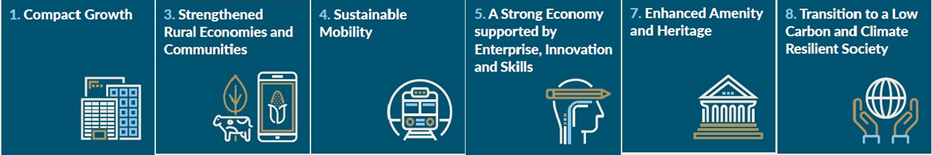
Related RSES Growth Ambitions

12.2 Settlement Hierarchy Overview
The Core Strategy sets out the settlement hierarchy for the County, which is informed by the settlement hierarchy in the RSES; job-to-work ratio, asset capacity matrix and the role/function of settlements in County Mayo, in order to determine an overall growth strategy and its position on the settlement hierarchy.
|
Settlement Type |
Settlements |
Role |
|
Tier I(a) Key Towns |
Ballina & Castlebar |
Large urban centres with a high level of jobs and services, with the capacity to act as significant economic growth drivers within the Mayo Catchment and wider region, including complementing the Galway Metropolitan Area and Sligo Regional Growth Centre. |
|
Tier I(b) Strategic Growth Town |
Westport |
Large urban centre with a high level of jobs and services, with the capacity to act as significant economic growth driver, in combination with its intrinsic links with Castle- bar, within the Mayo Catchment and wider region. |
|
Tier II Self- Sustaining Growth Towns |
Ballinrobe, Ballyhaunis, Béal an Mhuirthead (Belmullet), Claremorris & Swinford. |
Self-Sustaining Growth Towns with a moderate level of jobs and services and their own labour catchment areas. These towns have good transport links and have the capacity for continued sustainable growth. These towns play an important role in supporting the social, economic and cultural life within rural communities. |
|
Tier III Self- Sustaining Towns |
Balla, Charlestown, Crossmolina, Foxford, Killala, Kiltimagh, Knock, Louisburgh & Newport. |
Self-Sustaining Towns with low to moderate levels of population growth and a limited localised employment base and which are largely reliant on other areas for employment and/or services. These towns play an important role in supporting the social, economic and cultural life within rural communities. |
|
Tier IV Rural Settlements |
Ballindine, Ballycastle, Bangor Erris, Belcarra Bellavary, Bohola, Bunnyconnelan, Cong, Dumha Thuama (Doohoma), Gob An Choire (Achill Sound), Irishtown, Keel- Dooagh, Kilkelly, Kilmaine, Lahardane, Mulranny, Shrule & Turlough. |
Towns and villages with local service and limited employment functions, which play an important role in supporting the social, economic and cultural life within rural communities. |
|
Tier V Rural Villages |
Aghagower, Aghamore, An Tinbhear(Inver), Attymass, Ballycroy, Ballyglass, Ballyheane, Bekan, Breaffy,Brickens, Bun an Churraigh (Bunnacurry), Carnacon, Carracastle,Ceathrú Thaidhg (Carrowteige), Corrchloch (Corclough), Cross, Crossboyne, Doogort, Eachléim(Aghleam), Gaoth Sáile (Gweesalia),Geata Mór (Binghamstown), Gleannna Muaidhe (Glenamoy), Glenhest, Glenisland, Hollymount, Islandeady,Kilmovee, Knockmore, Mayo Abbey,Moygownagh, Moyne (Kilmeena),Parke, Partry, Poll an tSómas (Pollatomish), Roundfort, The Neale & Tuar Mhic Éadaigh |
Villages with local service functions, which play an important role in supporting the social, economic and cultural life within rural communities. |
Table 12.1: Mayo Settlement Hierarchy Table
12.3 Settlement Plans
Individual local area plans will be prepared for the Tier I towns of Ballina, Castlebar and Westport, as statutorily required under the Planning and Development Act 2000 (as amended)
Settlement Plans have been prepared for all Tier II, Tier III, Tier IV and Tier V towns and villages. These plans align with the Core and Settlement Strategy (Chapter 2) and were informed by the asset capacity matrix and the principles set out in Thriving Towns and Villages as per Figure 12.1 below. Each settlement is defined by a development boundary, wherein development is generally encouraged in an orderly sequential manner outward from the core area, depending on the nature of development and the function of the settlement within the Settlement Hierarchy. This pattern of development will maximise the utility of existing and future infrastructure provision in a manner that promotes sustainability, active travel and makes more efficient use of underutilised lands.
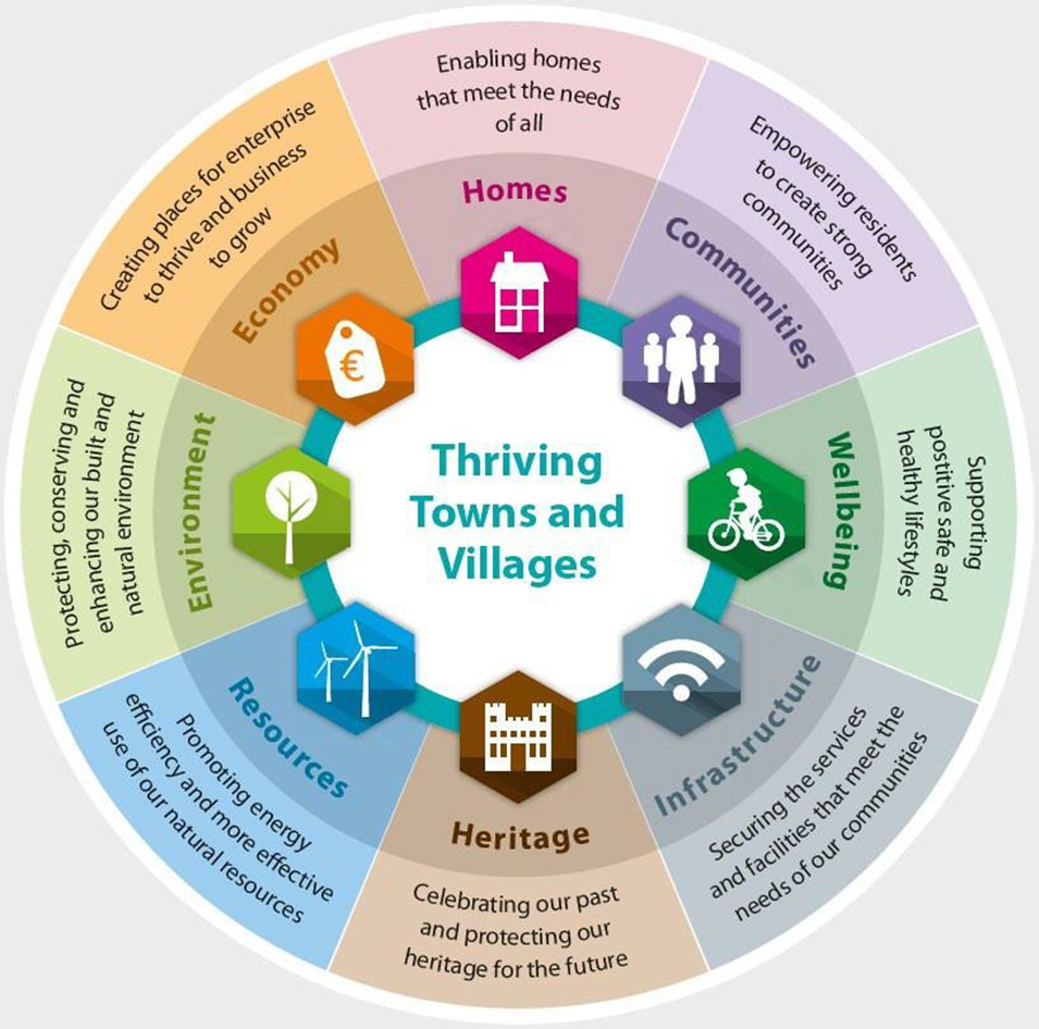
Figure 12.1 - Thriving Towns and Villages. Original Source - Plymouth Town Council
12.3.1 Land Use
12.3.1.1 Tier II Settlements
Tier II towns adopt a conventional land use zoning approach for all lands within the settlement plan boundary. This formal zoning approach identifies lands to accommodate various categories of development, as set out in Table 12.2 (Land Use Zoning Objectives). Table 2.3 (Land-use Matrix) provides guidance on compatible land uses within land use zoning categories
Land use zoning maps for Tier II settlements (Volume III: Book of Maps) identify ‘New Residential’ zoned land to accommodate housing targets over the plan period, as set out in the Core Strategy (Chapter 2). To safeguard and facilitate the delivery of housing targets allocations in each plan area, a two-tiered approach has been adopted for the Strategic Residential Reserve Lands. Strategic Residential Reserve Lands Tier I and Tier II will be assessed, on an annual basis, for their potential to meet settlement housing targets. Where it is apparent that lands zoned New Residential cannot or will not be developed within the plan period, residential developments, that demonstrate high quality design, may be considered on Strategic Residential Reserve Lands Tier 1 and in exceptional circumstances Tier 2. In this instance, the identified quantum of land required to accommodate housing targets in each settlement will not be exceeded. An effective monitoring system will be implemented to ensure housing targets for each Tier II towns are not exceeded over the plan period.
Town Centre Opportunity Sites have also been identified for Tier II towns to revitalise and repopulate town centre. These Opportunity Sites provide an indicative block framework for the future development of these lands and indicate appropriate development types and potential permeability pathways for pedestrians/cyclists and vehicles. It is envisaged that the 30% new household target within the town centre area (as set out in the Core Strategy), will generally be located within these lands.
A Rural Transition zoning category is provided along the perimeter of each settlement plan. This zoning category accommodates agricultural compatible developments, including single rural houses. It offers an opportunity to build a rural-type house close to a settlement, wherein the distance to employment, schools, retail and other services is reduced, thereby contributing to a reduction of County Mayo’s carbon emissions.
|
Land Use Zoning Objectives |
|
|
It is an objective of the Council to implement the following land use zoning objectives for lands in Tier II to V Towns and Villages: |
|
|
1a. Agriculture |
To reserve land for agricultural and rural uses and to preserve the amenity of the town setting. |
|
1b. Community Services/Facilities |
To provide land for community and social facilities. |
|
1c. Enterprise & Employment |
To provide land for light industrial and appropriate commercial development. |
|
1d. Industry |
To provide land for industrial use and ancillary facilities. |
|
1e. Infrastructure & Utilities |
To provide land for public infrastructure and public utilities. |
|
1f. Recreation & Amenity |
To provide land for recreation and amenity purposes. |
|
1g. Existing Residential |
To protect the amenity and character of existing residentialareas. |
|
1h. New Residential |
To provide for high quality new residential development andother services incidental to residential development. |
|
1i. Rural Transition |
To act as a transitional area between the build-up area and the rural hinterland. This zoning facilitates agricultural compatible development and renewable energy, including singlehouses on a limited basis, subject to demonstrable economic or social need (Refer to Objective RHO 1). |
|
1j. Strategic Residential Reserve Tier 1 |
To protect and safeguard suitable, undeveloped lands for future multiple residential developments. These lands are generally not developable during the lifetime of this plan for multiple residential developments. However, this position will be reviewed by the Planning Authority periodically over the lifetime of the plan to ensure housing growth targets are achieved (Refer to Core Strategy Table). Where it is apparent that ‘New Residential’ lands cannot or will not be developed within the plan period, residential development may be considered within Strategic ResidentialReserve Tier I. Single houses shall only be considered on a limited basis, where it has been established that the lands in question do not adversely impact on the intended future use of these lands; form part of the overall family landholding and no other appropriately zoned lands are available within the plan boundary; and a demonstrable economic or social need has been established (Refer to Objective RHO 1). |
|
1k. Strategic Residential Reserve Tier II |
To protect and safeguard suitable, undeveloped lands for future multiple residential developments. These lands are not developable during the lifetime of this plan for multiple residential developments. Where it is apparent that ‘New Residential’ or ‘Strategic Residential Reserve Tier I’ lands cannot or will not be developed within the plan period, residential development maybe considered within Strategic Residential Reserve Tier II. Single houses shall only be considered on a limited basis, where it has been established that the lands in question do not adversely impact on the intended future use of these lands; form part of the overall family landholding and no other appropriately zoned lands are available within the plan boundary; and a demonstrable economic or social need has been established (Refer to Objective RHO 1). |
|
1l. Town centre
(Inner and Outer) |
To maintain and enhance the vitality, viability and environment of the town centre and provide for appropriate town centre uses. |
|
1l. Opportunity Sites |
To promote the sustainable consolidation of towns and villages, with a focus on vacant, underutilised, infill and brown-field sites, to provide appropriate uses, including the delivery of high-quality residential, commercial, employment uses, and the delivery of renewable energy uses. |
|
1m. Self-Sustaining ConsolidationZoning (Tier III) |
To provide for, protect and strengthen the vitality and viability of Tier III Self-Sustaining towns, through consolidating development, and encouraging a mix of uses, including but not restricted to commercial, residential, industry, enterprise and employment, community, amenity, public realm enhancements, while maximising the use of land. |
|
1n. Rural Settlements ConsolidationZoning (Tier IV) |
To provide for, protect and strengthen the vitality and viability of Tier IV Rural Settlements, through consolidating development, and encouraging an appropriate mix of uses commensurate with the character, capacity and connectivityof the rural village, including but not restricted to retail, commercial, residential, community, amenity, and public realm enhancements, while maximising the use of land. |
|
1o. Rural Village Consolidation Zoning (Tier V) |
To provide for, protect and strengthen the vitality and viability of Tier V Rural Villages, through consolidating development, and encouraging an appropriate mix of uses commensurate with the character, capacity and connectivityof the rural village, including but not restricted to retail, commercial, residential, community, amenity, and public realm enhancements, while maximising the use of land. |
Table 12.2 Land Use Zoning Objectives for Settlement Plans
|
Land Use Zoning Matrix |
|
|
Land Use Zoning |
Uses Generally Permitted |
|
New Residential
(≤20 units/Ha) |
Houses, apartments, retirement homes, care homes, medical services, public and community facilities, institutional uses, childcare facilities, places of worship, local shops, local services, leisure & recreation, open space; along with uses that are considered ancillary to the aforementioned uses. Local and home offices may be acceptable, provided that there is no detrimental impact on residential amenity or traffic and that the use does not prejudice the primary use of the town centre for office use. All proposals that would be detrimental to established or future residential amenity will not be permitted. These include industrial and warehousing and uses generating significant levels of traffic, noise and other nuisance. |
|
Existing Residential |
Permitted in principle uses include residential, sheltered Housing, B&B/guest house, community facility/centre, home based economic activities and utilities. Open to Consideration uses include but not limited to bring banks, convenience outlet, childcare facility, halting site, sheltered housing, healthcare practitioner, leisure/recreation/sports facilities, bar, retirement home/residential institution/retirement village, and veterinary surgery. |
|
Strategic Residential Reserve Tier I and II |
Future residential lands, not generally developable in the lifetime of the plan for multiple residential development schemes (see land use zoning objectives for Strategic Residential Reserve Tiers I & II). Temporary uses and single houses will be considered on their individual merits, subject to the use not adversely impacting on the intended future use of these lands to accommodate future population/housing targets in subsequent plans. Single houses will be considered on a limited basis, where it is established that the lands in question are part of the overall family land holding, no other appropriately zoned lands are available within the plan boundary and a demonstrable economic or social need has been established (Objective RHO 1). |
|
Town Centre |
Shops (including supermarkets), off-licenses, offices, civic and public buildings, places of worship, public houses, hotels, restaurants, indoor leisure, car parks, apartments, houses, community facilities, parks and open spaces and retirement homes; along with uses that are considered ancillary to the aforementioned uses.
Uses that would be detrimental to the vitality and amenity of the town centre, such as industrial uses, will not normally be permitted. |
|
Town Centre Opportunity Sites
Residential High Density (≤35 units/Ha) |
Residential and appropriate mixed use, community, amenity and public realm or other uses generally considered acceptable in town centre locations.
Uses that would be detrimental to the vitality and amenity of the town centre, such as industrial uses, will not normally be permitted. |
|
Opportunity Sites |
To provide for residential and appropriate mixed use, community, nursing homes, amenity and other uses generally considered acceptable by reason of location and context. |
|
Opportunity Site (Claremorris): |
To provide for the production of electricity by renewable energy technologies, incorporating wood Biomass only. To provide for a mix of industries (with no production of wood chip or wood pellets on this site) or research and development facilities where it is established that there is a need to locate such uses, within, adjacent or in close proximity to the primary user of the site (i.e. for the production of electricity from renewable energy technologies, incorporating wood Biomass only) or where it is established that there is insufficient appropriately zoned lands to facilitate such uses. |
|
Enterprise & Employment |
Light Industry, Warehousing (retail and non‐retail), Major Offices, Business and Technology Units, Specialist Offices, R&D enterprises, car showrooms, light engineering works, wholesale and trade outlets, public utilities, petrol filling stations, builders providers, repair garages, civic amenity centres, agriculture outlets, distribution depots, heavy vehicle parks, workshops, tourism related development; along with uses that are considered ancillary to the aforementioned uses. Extensions to existing retail premises will be considered on a case-by-case basis. Uses that would prejudice the primacy of town centre or would undermine the objectives of other land use zoning will not be permitted. |
|
Industry |
Industry, Light Industry, Heavy Engineering Works, Warehousing (non-retail), Business & Technology Units, R&D Enterprises; along with uses considered ancillary to the aforementioned uses. Uses that would prejudice the primary industrial function of this zoning or would undermine the objectives of other zoning will not be permitted. These include residential and retail uses. |
|
Infrastructure & Utilities |
Public utilities infrastructure, public and civic facilities and public infrastructure, along with uses considered ancillary to the aforementioned uses. |
|
Recreation & Amenity |
Outdoor sport and recreation, buildings associated with outdoor sport and recreation and ancillary uses, parks, open space, camp sites, agriculture, allotments; along with uses that are considered ancillary to the aforementioned uses. Temporary markets and exhibitions may be permitted. |
|
Community Service/ Facilities |
Schools and education, places of worship, community centres, health centres, leisure and recreation, retirement/nursing homes, libraries, cemeteries, open space, childcare facilities, public and civic facilities; along with uses that are considered ancillary to the aforementioned uses. |
|
Rural Transition |
Agriculture, renewable energy, open space, public utilities, outdoor, recreation, camp sites, allotments and cemeteries; along with uses that are considered ancillary to the aforementioned uses. New houses will be considered in this zone on their individual merits. |
|
Agriculture |
Agriculture, renewable energy, open space, public utilities, outdoor, recreation, retirement/nursing homes, camp sites, allotments and cemeteries; along with uses that are considered ancillary to the aforementioned uses. New houses will only be permitted in this zone to applicants with demonstrable economic or social need to live in these areas. |
Table 12.3: Land Use Matrix for Tier II Settlement Plans
Advise Note: Where a use is proposed that is not listed in the matrix, development proposals will be assessed on their individual merits in accordance with the general guidance provided by the matrix and having regard the principles of proper planning and sustainable development of the area and compliance with the relevant policies and objectives (including land use zoning objectives), standards and requirements as set out in the Plan.
12.3.1.2 Tier III, IV and V Towns and Villages
All Tier III, IV and V towns and villages adopt a single category consolidation land use zoning. This flexible zoning approach provides for a mix of development types that supports the sustainable consolidated growth of these rural towns and villages. All proposals must be compatible with existing adjoining land uses, the character of the area and should also encourage Active Travel. Opportunity Sites have also been identified for Tier III towns. These sites are located within or close to the core of each settlement and seek to guide residential development in a manner that revitalises and repopulates town centres.
12.3.2 Tier II and Tier III Settlements
The general policies and objectives for Tier II and Tier III settlements Plan are set out below. The settlement plans provide information on each Self-Sustaining Growth Towns (Tier II) and Self- Sustaining Towns (Tier III) developed from the asset capacity matrix and the principles of Thriving Towns and Villages (Figure 12.1). A conventional zoning map is provided for each Tier II town (Refer to Volume III - Book of Maps), along with identification of town centre opportunity sites, followed by town specific policies and objectives. A single category mixed-use zoning map is provided for each Tier III town, along with identification of opportunity sites, followed by town specific policies and objectives.
|
General Tier II and III Settlement Policies |
|
|
GSP 1 |
To support and promote commensurate population, service and employment growth, to enable the Tiers II and III settlements to fulfil their role as a self-sustaining growth towns and self-sustaining towns, respectively. |
|
GSP 2 |
To support and encourage the development/redevelopment of identified Town Centre Opportunity Sites in Tier II and Tier III settlements. |
|
GSP 3 |
To support the provision of mixed-use developments in the town centre which create opportunities to live, work, shop, etc., within the town and reduce the propensity to travel by private car. |
|
GSP 4 |
To encourage re-development of all derelict buildings within all settlement plan areas listed on the Derelict Sites Register. |
|
GSP 5 |
To support and promote the re-use and regeneration of derelict land and other buildings in town centre areas for retail and other appropriate uses with due cognisance to the Sequential Approach prescribed in the retail planning guidelines 2012 or amended or superseding guidelines. |
|
GSP 6 |
To encourage the appropriate use of unoccupied/derelict buildings in the town for start- up businesses and community facilities. |
|
GSP 7 |
To co-operate with relevant agencies to secure improvements to the public transport system serving Tier II and III settlement towns and to support initiatives designed to improve bus interchange facilities. |
|
GSP 8 |
To support the establishment of green routes and an accessible walking / cycling network throughout the settlement plan areas and surrounding areas that provides safe and attractive circulation routes for pedestrians and cyclists for the enjoyment and recreational use of the entire community by linking residential areas, community facilities, amenities and the town centre. |
|
GSP 9 |
To support and encourage Irish Water in increasing the provision of adequate wastewater and water infrastructure, to ensure that services are delivered in line with the further development and growth of settlements. |
|
GSP 10 |
To support and encourage key stakeholders/providers in increasing the provision of adequate key physical infrastructure (i.e. transportation, parking, communications, energy etc.) and to support the provision of key social infrastructure (health care services, education facilities, burial grounds, fire and emergency services, recreational, cultural facilities etc.) in Tier II and Tier III settlements. |
|
General Tier II and III Settlement Objectives |
|
|
GSO 1 |
To ensure appropriate development occurs in a sequential manner outward from the core area, to maximise the utility of existing and future infrastructure provision, to promote sustainability and active travel, to make more efficient use of underutilised lands, and to avoid the inappropriate extension of services and utilities. |
|
GSO 2 |
To encourage and facilitate the development of the economic and tourism potential of towns in a manner that respects, builds on, protects and enhances the cultural, built heritage, natural heritage and local amenities of the town. |
|
GSO 3 |
To ensure that the town centre is accessible to all members of the community, including people with mobility issues, the elderly and people with young children. |
|
GS0 4 |
To work with Irish Water and landowners on the “New Homes in Small Towns and Villages” initiative to augment the delivery of actions by Local Authorities, Irish Water, communities and other stakeholders in the provision of services and serviced sites to create “build your own home” opportunities within the existing footprint of settlements, to meet housing demand. |
|
GSO 5 |
To require proposals for new development to integrate with existing Green Infrastructure networks and contribute to the development and protection of overall Green Infrastructure assets. |
|
GSO 6 |
To use active land management measures, such as the Vacant Site Levy (Urban Regeneration and Housing Act 2015, as amended) and Derelict Site Levy (The Derelict Sites Act 1990 (as amended)), to ensure the delivery of the projected housing units in the identified Town Centre Opportunity Sites and residential zoned lands in Tier II Self- Sustaining Growth Towns, as set out in the Core Strategy or any subsequent Town Centre Opportunity Sites identified over the lifetime of the plan. |
|
GSO 7 |
To promote and facilitate the delivery of multiple residential development in the identified Opportunity Sites for Tier III Self-Sustaining Towns or any subsequent Opportunity Sites identified over the lifetime of the plan. |
|
GSO 8 |
To ensure applications for development within the settlement boundaries on lands identified as flood risk areas including benefitting lands, shall be subject to a Specific Flood Risk Assessment and Justification Test, in accordance with the Planning System and Flood Risk Management – Guidelines for Planning Authorities, 2009 or any superseding guidelines and circulars. |
|
GSO 9 |
To facilitate, identify, support and secure a strategic footpath and cycleway network throughout the plan areas, as appropriate and as resources allow. |
|
GSO 10 |
To support and facilitate pedestrian mobility and safety in Tier II and III towns by introducing traffic calming measures and pedestrian crossings, where necessary. |
|
GSO 11 |
To support and where possible, implement measures to create interpretative walking routes in and around Tier II and III towns, linking to special features of built and natural heritage interest. |
|
GSO 12 |
To develop the local economy by encouraging additional commercial businesses and industries and to promote the clustering of such industries on suitably zoned land in Tier II settlements and at appropriate locations within Tier III settlements. |
|
GSO 13 |
To protect the role of the town centre as the dominant retailing and commercial area. |
|
GSO 14 |
To implement the land use zoning objectives in each Tier II settlement plans. |
|
GSO 15 |
To actively provide or facilitate the provision/upgrade of identified infrastructural deficiencies in settlement plan areas. |
12.4 Ballinrobe (Tier II)
12.4.1 Location and Context
Ballinrobe town is situated along the main Galway to Castlebar road at the junction of the N84 National Secondary Road and the R334 Regional Road. The town is approximately 50km north-west of Galway City, 30km south from Castlebar and 36km southeast of Westport. The Ballinrobe area is known as the ‘Lake District’ of Mayo and the town is well located for easy access to some of the most scenic areas in Ireland.
The population of Ballinrobe has more than doubled in size (112.8%) over the last twenty years, from 1,309 persons in 1996 (Census figures) to 2,786 persons in 2016 (Census figures). Ballinrobe is the 5th largest settlement in Mayo, the 19th largest in the Western Region and the 124th largest in the State. According to POWCAR 2016, the total number of jobs located within Ballinrobe was 1,077. The Ballinrobe labour catchment is the 27th largest labour catchment in the Western Region with a resident ‘at work’ population of 1,859, and a job to work ratio of 0.969.
12.4.2 Historical Context and Settlement Form
The Irish place name for Ballinrobe is Baile an Róba, which translates as “town of the (river) Robe”. Ballinrobe is said to be the oldest town in Mayo and dates back to 1390. Ballinrobe was first established as a market town in 1605, with the town’s role as a garrison town during British rule still very much evident today, in the form of the town’s rich built heritage. The town has one of the highest concentrations of protected structures in the county. This reflects the historic significance of the town and the important role these buildings play in defining its character and identity. The town has a relatively compacted form framed around a central urban block, with existing residential areas generally located outside of the town centre core.
12.4.3 Function and Vision
Ballinrobe is situated within the Claremorris-Swinford Municipal District. The town provides a wide range of services and facilities to meet the daily needs of the local population. It is an important service town for the wide agricultural hinterland of south Mayo and north Connemara. Ballinrobe also functions as a Gaeltacht Service Town for the nearby Clonbur and Tourmakeady Gaeltachtregions.
It is envisioned that Ballinrobe, along with the Claremorris and Ballyhaunis, can form a Growth Cluster in South Mayo to harness their combined strengths to contribute towards the consolidation of the Atlantic Economic Corridor. Opportunity exists in the town for regeneration and consolidated growth within the existing built footprint.
12.4.4 Economic Development
The main employment sectors in the town according to Census 2016 is the Services Sector (32%), followed by Education, Human Health and Social Work (20.5%) and Manufacturing Industries (16.9%). The town is well served in terms of convenience and comparison shopping, with three of the main supermarket chains located in or close to the town centre. The town also contains several local independent shops. Potential exists in the town centre in the form of appropriately located, undeveloped lands and the re-use of existing vacant buildings, to further enhance the convenience and comparison retail offer. Ballinrobe is home to McHale Engineering, a successful indigenous business in both the domestic and international agricultural industry, providing innovative technologies in agricultural machinery. The business has a large employment base drawing from Ballinrobe and the surrounding hinterland.
12.4.5 Social Infrastructure
Ballinrobe serves as the retail centre and employment base for a larger rural catchment area and provides a range of services, social and community facilities, including a library, garda station, county council office, post office, medical centres, pre-school, primary school, secondary school, churches, banks, enterprise centre, retail shops and public houses within the town. Ballinrobe also has numerous community, sporting and social clubs. Sports and recreational facilities in the town comprise of a racecourse, GAA, soccer pitches, rugby pitches, and children’s playground. The town has an active Community Development Council, their objectives include creating sustainable local development, seeking additional infrastructural services and improving the socio-economic conditions in the town. The Bowers Walk, along the River Robe, and The Green constitute valuable natural amenities and visitor attractions for the town.
12.4.6 Physical Infrastructure
Ballinrobe is served by the N84, R331 and R334 national and regional road network. The town is served by an existing municipal wastewater treatment plant (8,000PE) and a water supply from the Lough Mask Regional water supply scheme. There is sufficient capacity for the projected population increase as set out in the Core Strategy. The town also benefits from fibre optic broadband infrastructure (Metropolitan Area Network and VDSL broadband) and has a connection to the national gas grid. A dismantled railway line between runs between Ballinrobe and Claremorris, providing an opportunity to re-establish the line as a walking cycling route or as a spur of the Western Rail Corridor.
12.4.7 Heritage and Tourism
Ballinrobe is rich in built heritage with protected structures (35), NIAH structures (35) and local vernacular buildings, all of which are reflective of the historical development, sense of place and character of the town. The protection, promotion and enhancement of the built and natural heritage of the town and its immediate environs is promoted in this plan. Mayo County Council has carried out habitat mapping in Ballinrobe, which has informed the identification of Local Biodiversity Areas in the town, while an Action Plan has been prepared for Ballinrobe, aimed at conserving and enhancing the natural heritage of the town. The Bowers Walk is an important amenity for locals and visitors to Ballinrobe. This riverside walk stretches for approximately 3 kilometres along the River Robe starting at the bridge, on Bridge Street towards Creagh Bridge and along the old towpath of the canal. Swans and wildlife are plentiful along the walk, together with a variety of flora and fauna when inseason.
Lough Mask is home to the annual trout fly fishing World Cup Championship, which attracts significant numbers of tourists into the town. Horse racing forms an important part of the Ballinrobe’s heritage and also acts as tourist driver for the town. Ballinrobe is also a base to visit other notable tourist attractions such as Bowers Walk heritage trail, Ballinrobe Golf Course, Ballinrobe Racecourse, Cong, Ballintubber Abbey, Moore Hall; and within easy access to Ireland West Airport Knock. Potential exists for the development of tourist accommodation for visitors travelling to and from these locations. This plan seeks to encourage appropriate development within the town to facilitate and support its tourism potential.
12.4.8 Sustainable Communities
Ballinrobe provides an attractive place to live, is rich in heritage, natural beauty and amenity. The town plays an important economic, social and cultural role for the inhabitants of the town itself and the wider hinterland. The town has good community stakeholder engagement and an active Tidy Towns committee. In order to help create sustainable communities, the development strategy for Ballinrobe is to support new housing and population growth, consistent with the Core Strategy. The NPF and RSES recognise that settlement patterns play a fundamental role in influencing how people travel, both the distances undertaken and the modal choice. New housing will be accommodated through facilitating compact growth and the through revitalisation of the historic town core, together with providing of a mix of housing types, densities and tenure to meet the needs of the area. A strong emphasis is placed on building communities with a high standard of design, the principles of place-making, green infrastructure, permeability and connectivity alongside the integration of community and recreation facilities.
12.4.9 Sustainable Travel
Ballinrobe is located on the main daily bus route between Westport and Galway. A local community bus service, operated by the Mayo Local Link, also serves the town and the surrounding hinterlands. The number of people who walk to their place of work, study and other services in town is above the national average (9.3%). According to 2016 POWCAR, 12.8% of the daily population walk. However, use of cycling as a sustainable mode of travel is less than 1%, compared to the national average (3%). Therefore, Mayo County Council promotes and supports the development of public transport initiatives, in keeping with the principles of Smarter Travel. Increasing the usage of cycling in the town will require further study (audit), including the provision of new or retrofitted infrastructure and adherence to DMURS guidance standards.
12.4.10 Placemaking and Regeneration
Ballinrobe provides the focus for a wide range of activities that contribute to a sense of place and identity. The town has a compact town centre with strong continuous street frontages of two and three storey buildings. It has relatively narrow street proportions and resultant traffic congestion. The two iconic water storage towers provide a sense of place for the town. A number of studies have taken place in Ballinrobe to enhance its urban fabric and address the issues of vacancy within the town centre, including a Town Renewal Scheme study (2000); a Public Realm Plan (2018); as well as projects carried out under the Historic Towns Initiative scheme; and an Adaptive Reuse Project (2019). The Public Realm Plan includes key objectives around the sustainable reuse of existing buildings and a need to encourage town centre living. A number of successful projects have received funding under the Rural Regeneration and Development Fund, including regeneration works for the development of Market House, the town library grounds and an upgrade of The Bowers Walk.
In terms of placemaking, the main priority is the consolidation of the town centre and support of existing business in order to maintain vibrancy. A challenging issue facing Ballinrobe is the extent of dereliction and vacancy in the town centre, with notable concentrations of vacant structures along Main Street, Glebe Street and especially Bridge Street. Many buildings in the town centre lend themselves for suitable for renovation of upper storeys into residential use. Ground floors should, however, be prioritised for commercial and community uses that activate the street, where possible. Together, these will help sustain town vibrancy, including the evening economy. Accordingly, the potential for more appropriate use of under-utilised sites, vacant sites and buildings within the existing built-up footprint of Ballinrobe, will aid the delivery of quality housing, services and employment opportunities, in tandem with supporting social infrastructure is promoted.
A main priority of the Ballinrobe Settlement Plan is the regeneration and repopulation of the town centre, through the sustainable reuse of existing buildings, focusing on dereliction and the appropriate development of infill opportunity site(s), underpinned by good urban design and placemaking principles.
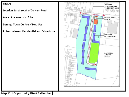
12.4.11 Town Centre Opportunity Sites (Refer to Map BR 2)
Site A - Convent Road/New Street
A site has been identified along Convent Road in Ballinrobe town centre, which presents opportunity to increase population within the town centre in line with the Core Strategy. This two- hectare site is strategically located to the east of the town centre. An indicative framework has been provided for the site to guide its potential development.
Site B – Cranmore House
No indicative development framework has been developed for Site B, owing to the presence of Cranmore House which is a Protected Structure (RPS No. 76). Any future development must prepare a site brief / masterplan for the proposed site and carefully consider the impacts in the Protected Structure.
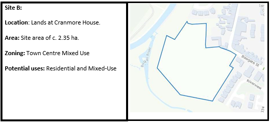
Map 12.2 Opportunity Site B Ballinrobe
Site C – Bog Road
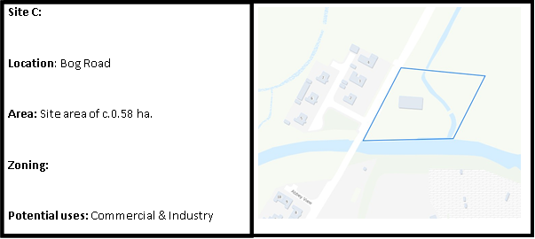
Map 12.3 Opportunity Site C Ballinrobe
Site D – Watson’s Lane
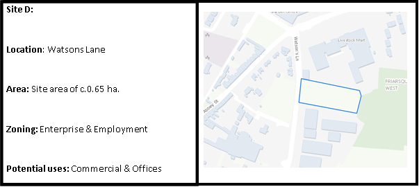
Map 12.4 Opportunity Site D Ballinrobe
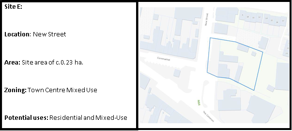
Map 12.5 Opportunity Site E Ballinrobe
|
Ballinrobe Settlement Plan Policies |
|
|
BRP 1 |
To promote the development of Ballinrobe, as a driver of economic growth for the south region of County Mayo and fulfil its role as a designated Self-Sustaining Growth Town and support the potential for the creation of an Economic Growth Cluster in tandem with the towns of Ballyhaunis and Claremorris. |
|
BRP 2 |
To promote and support the re-development and refurbishment of Bridge Street/High Street whilst safeguarding the protected structures and their curtilages along the street. |
|
BRP 3 |
To promote and support the appropriate refurbishment of Cranmore House and the Military Barracks for amenity and cultural purposes. |
|
BRP 4 |
To promote and support the re-establishment of the Ballinrobe to Claremorris dismantled railway line as a walking and cycling route or as a spur line of the Western Rail corridor. |
|
BRP 5 |
To promote and support the enhancement and extension of The Bowers Walk River walkway and safeguard the value of the river as an ecological “green corridor”. Riverside walkway provisions should be incorporated, where appropriate, into development proposals bounding the river. |
|
BRP 6 |
To promote and support the implementation of the projects listed within the Ballinrobe Public Realm Plan during the plan period, to improve attractiveness and permeability of the public realm. |
|
Ballinrobe Settlement Plan Objectives |
|
|
BRO 1 |
To ensure infill development respects the unique height-to-width ratio with respect to building design in Ballinrobe town centre and maintain the existing sense of enclosure on town centre streets. |
|
BRO 2 |
To consider the designation in the town centre of an Architectural Conservation Area, including all or parts of Bowgate Street, Main Street, High Street/Bridge Street, Glebe Street and Abbey Street. |
|
BRO 3 |
To support and facilitate the development of the two identified Town Centre Opportunity Sites in Ballinrobe for appropriate uses, as outlined in Section 12.4.11, and as generally permitted on Town Centre Opportunity Sites in the Land Use Zoning Matrix (Refer to Map BR 2). |
|
BRO 4 |
To seek and encourage ways to make more use of the Cornmarket area, including making the area pedestrian and market-place friendly and encourage and support the provision of a weekly market in the Cornmarket area. |
|
BRO 5 |
To protect the water quality and riparian zone of the rivers Robe and Bulkan. Any proposed developments adjacent to or close to watercourses shall be carefully assessed to ensure that there is no adverse impact to the water course, its riparian zone or to any waterbody into which it flows. |
|
BRO 6 |
To seek to make Tree Preservation Orders for the tree groups along the River Robe and important tree groups in the town. |
|
BRO 7 |
To encourage development in the town of Ballinrobe in accordance with the Land Use Zoning Map. |
|
BRO 8 |
To encourage and facilitate the re-use and regeneration of derelict land and buildings for retail and other town centre uses with due cognisance to the Sequential Approach prescribed in the Retail Planning Guidelines 2012. |
|
BRO 9 |
To use active land management measures, such as the vacant site levy and derelict site levy to ensure the delivery of the projected housing units for Ballinrobe, as set out in the Core Strategy, on Town Centre Opportunity Sites and residential zoned lands. |
12.5 Ballyhaunis (Tier II)
12.5.1 Location and Context
Ballyhaunis is located in east Mayo at the intersection of the N60 and N83 national routes and within close proximity to a number of large urban centres such as Claremorris and Tuam. The town also lies on the Dublin-Westport railway line and provides a wide range of services and amenities to a significant rural hinterland.
The population of Ballyhaunis has nearly doubled in size (84%) over the last twenty years, from 1,287 persons in 1996 (Census figures) to 2,366 persons in 2016 (Census figures). Ballyhaunis is the 6th largest settlement in Mayo, the 27th largest in the Western Region and the 147th largest in the state. According to POWCAR 2016, the total number of jobs located within Ballyhaunis was 1,226. The Ballyhaunis labour catchment is the 21st largest labour catchment in the Western Region with a resident ‘at work’ population of 2,601 and a job to work ratio of 1.460.
12.5.2 Historical Context and Settlement Form
Béal Átha hAmhnais translates to "ford-mouth of strife". The footprint of the town has developed primarily to the west of the River Dalgan, focussed around four main streets: i.e. Main Street, Knox Street, Bridge Street and Clare Road. The town originally developed around the Augustinian Friary, which dates from 1348. The structure of the settlement is well defined with retail and commercial uses primarily located within its town core, and with educational, institutional and community uses generally located on the outskirts.
12.5.3 Function and Vision
Ballyhaunis is located in the Claremorris Municipal District. The town is an important employment base in the east of the county, particularly in the areas of food processing, agri-engineering and manufacturing. Mayo County Council promotes the consolidation of growth within the established footprint of the town in conjunction with regeneration, public realm enhancement, while supporting local employment and the expansion of services to meet the needs of residents and visitors. It is envisioned that Ballyhaunis, along with the Claremorris and Ballinrobe can form a Growth Cluster in South Mayo to harness their combined strengths to contribute towards the consolidation of the Atlantic Economic Corridor.
12.5.4 Economic Development
Ballyhaunis has an established industrial and manufacturing base in the town. According to 2016 POWCAR figures Manufacturing Industries account for 27.3% of the main employment sectors in the town, which is significantly higher that the state average (13%). The other main employment sectors in the town include the Service Sector (19.3%) and ICT and Professional Services (9%).
The key economic activities in Ballyhaunis are concentrated in a number of significant companies that relate directly and indirectly to the food processing industry. The town also has a range of other manufacturing industries that includes furniture, plastics and kitchen construction. A range of medium to small retail outlets, as well as employment in the state sector and the financial sector provide important employment in the town. Opportunities also exist for start-ups and incubation hubs in Ballyhaunis at the Enterprise Centre, located centrally. Additionally, Ballyhaunis remains an important service town for a wide agricultural hinterland in East Mayo and with a reach into County Roscommon.
12.5.5 Social Infrastructure
Ballyhaunis serves as the retail centre and employment base for a larger rural catchment area and provides a range of services, social and community facilities, including a library, outdoor swimming pool, garda station, post office, medical centres, pre-school, primary school, secondary school, two churches, bank, enterprise centre, retail shops and public houses within the town. It is also home to Ireland's first purpose-built mosque. Ballyhaunis also has numerous community, sporting and social clubs. Sports and recreational facilities in the town comprise of a GAA club, a rugby pitch, children’s playgrounds, Multi Use Games Area (MUGA) and outdoor gym at the Friary grounds. The Abbey Walk, along the Dalgan River, at the Friary grounds, also constitutes a valuable natural amenity and visitor attraction for the town.
12.5.6 Physical Infrastructure
Ballyhaunis is served by the N60 and N83 National Roads. The town also has direct rail links to Dublin, is located within twenty-minute drive of Ireland West Airport Knock and has VDSL broadband (Very high-speed Digital Subscriber Line) available. Ballyhaunis is served by an existing municipal wastewater treatment plant (4,000PE) and a water supply from the Lough Mask regional water supply scheme. There is sufficient capacity in this infrastructure to cater for the projected population increase as set out in the Core Strategy.
12.5.7 Tourism and Heritage
The Augustinian Friary in Ballyhaunis is the second oldest friary in Mayo, after Ballintubber Abbey. The Friary and its grounds and graveyard are a prominent cultural amenity and tourist attraction in the town. Other tourist attractions include Ballyhaunis Golf Course, a 9-hole parkland course situated on the N83 on the outskirts of the town. Knock Shrine, Connaught GAA Centre of Excellence and Ireland West Airport Knock are in close proximity to Ballyhaunis. Potential exists for the development of tourist accommodation in the town for visitors travelling to and from these locations. The Friary Ground in Ballyhaunis also serves as an important natural amenity for locals and visitors alike, and includes a walkway along the river, playground, MUGA and outdoor gym, along with a new sensory garden and an abundance of flora and fauna.
12.5.8 Sustainable Communities
Ballyhaunis is rich in culture, heritage and amenity, with a diverse mix of cultures and nationalities. The town is the most diverse and inclusive in the country in the 2016 Census, with migrants from 20 different ethnicities making up more than half of the population. Ballyhaunis is a good example of a mixed community, living, working and co-operating together, to create a great place for people to live and bring up families. The town also has good community stakeholder engagement and an active Tidy Towns committee. In order to help create sustainable communities, the development strategy for Ballyhaunis is to support new housing and population growth, consistent with the Core Strategy.
The NPF and RSES recognise that settlement patterns play a fundamental role in influencing how people travel, both in terms of the distances undertaken and the modal choice. Stronger connections and linkages between residential settlements and the town centre is important in ensuring sustainable communities. The NPF and RSES recognise that settlement patterns play a fundamental role in influencing how people travel, both the distances undertaken and the modal choice. New housing will be accommodated through facilitating compact growth and the through revitalisation of the historic town core, together with providing of a mix of housing types, densities and tenure to meet the needs of the area. A strong emphasis is placed on building communities with a high standard of design, the principles of place-making, green infrastructure, permeability and connectivity alongside the integration of community and recreation facilities. In this regard, a number of Town Centre Opportunity Sites have been identified to encourage development within the town centre.
12.5.9, Sustainable Travel
The number of people who walk to their place of work, study and other services in town is above the national average (9.3%). According to 2016 POWCAR, 15.71% of the daily population walk. However, use of cycling as a sustainable mode of travel is less than 1%, compared to the national average (3%). Therefore, Mayo County Council promotes and supports the development of public transport initiatives, in keeping with the principles of Smarter Travel. Increasing the usage of cycling in the town will require further study (audit), including the provision of new or retrofitted infrastructure and adherence to DMURS guidance standards.
12.5.10 Place Making and Regeneration
Ballyhaunis provides the focus for a wide range of activities that contribute to a sense of place and identity. Public realm enhancement works have been completed at Market Square, Knox Street, Clare Street and Bridge Street through funding received under the Town and Village Renewal Scheme. These public realm enhancement and refurbishment works comprised of paving, upgrading of pedestrian footpaths and crossings, undergrounding of overhead cables, new public lighting, surface water alleviation works, all of which have visually enhanced the attractiveness of the town centre. These works also provide social and environmental benefits to the local community and to visitors to the town, encouraging economic growth and providing a pedestrian bias within the town centre. It is envisaged these works will act as a catalyst to assist with the revitalisation of existing building stock along Main Street, Knox Street, Bridge Street and Clare Street.
Funding has also been received through the Rural Regeneration Development Fund to prepare a design brief for the former convent school on Abbey Street for its redevelopment for community use as a workspace hub and to support local enterprise. The design brief also includes a new public plaza adjoining the community hub building and a new pedestrian bridge connecting the plaza to the public swimming pool. Restoration of the existing riverside walk along the River Dalgan, the creation of a new circular walking route through the town and provision of a new cover and heating facilities at the public outdoor swimming pool have greatly improved the amenity offering of the town.
12.5.11 Town Centre Opportunity Sites
The potential exists for better use of under-utilised and vacant sites within the town centre area of Ballyhaunis, to drive the delivery of quality housing, services and employment opportunities, in tandem with supporting social infrastructure. In this regard, four town centre opportunity sites have been identified in the town. An indicative development framework has been provided for each site to guide developers.
Site A: Lands east of Aisling Drive
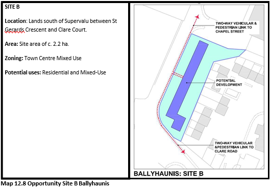
Site B: Lands south of Supervalu between St Gerards Crescent and Clare Court.
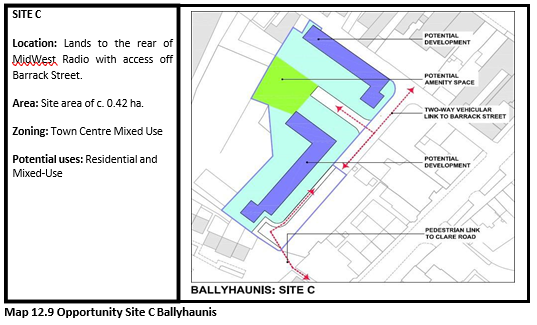
Site C: Lands to the rear of MidWest Radio with access off Barrack Street.
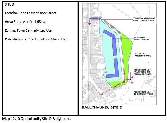
Site D: Lands east of Knox Street
The redevelopment of these sites presents an opportunity to further contribute to the rejuvenation and revitalisation of Ballyhaunis and to enhance the overall improvement of the public realm and visual amenity of the area.
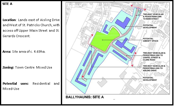
Map 12.7 Opportunity Site A Ballyhaunis
|
Ballyhaunis Settlement Plan Policies |
|
|
BSP 1 |
To promote the development of Ballyhaunis as a driver of economic growth for the southeast region of County Mayo and fulfil its role as a designated Self-Sustaining Growth Town and to further investigate the potential for the creation of an Economic Growth Cluster, in tandem with the towns of Ballinrobe and Claremorris. |
|
BSP 2 |
To protect St. Mary’s Abbey and its associated lands as one of the town’s key tourist attractions. |
|
BSP 3 |
To support community-led developments, where appropriate, including the implementation of Community Futures Action Plan for Ballyhaunis (2016-2021) or any amended or superseding Community Futures Plan for the town. |
|
BSP 4 |
To promote and support the enhancement and extension of the Dalgan River walkway and to safeguard the value of the river as an ecological “green corridor”. Riverside walkway provisions should be incorporated, where appropriate, into development proposals bounding the river. |
|
BSP 5 |
To promote the town’s strategic location in relation to Ireland West Airport Knock. |
|
Ballyhaunis Settlement Plan Objectives |
|
|
BSO 1 |
To improve the attractiveness of the built fabric of the town centre, including the encouragement of appropriate redevelopment and renewal of vacant sites and buildings, in particular Knox St, and to ensure high architectural quality in all new developments. |
|
BSO 2 |
To support and facilitate the development of the four identified Town Centre Opportunity Sites in Ballyhaunis for appropriate uses, as outlined in Section 12.5.11, and as generally permitted on Town Centre Opportunity Sites in the Land Use Zoning Matrix (Refer to Map BS 2). |
|
BSO 3 |
To continue to facilitate the further development of the Abbey Walk as an amenity/ recreation area in Ballyhaunis. |
|
BSO 4 |
To provide a civic amenity facility in Ballyhaunis. |
|
BSO 5 |
To continue to encourage rail use as a sustainable mode of transport and to promote the upgrading of the rail services to the town and connecting bus services. |
|
BSO 6 |
To ensure the future protection of lands adjacent to the railway station from inappropriate development that could jeopardize the long-term viability and improvement of the transport facility. |
|
BSO 7 |
To protect the water quality and riparian zone of the Dalgan River and to encourage appropriate developments that enhance its landscape setting and public benefit. |
|
BSO 8 |
To facilitate the construction of the town’s outer bypass. |
|
BSO 9 |
To ensure that the strategic importance, capacity and safe operation of the Knock Link Road is maintained by restricting the number of access points entering and exiting onto the road. |
|
BSO 10 |
To encourage development in the town of Ballyhaunis in accordance with the Land Use Zoning Map. |
|
BSO 11 |
To encourage and facilitate the re-use and regeneration of derelict land and buildings for retail and other town centre uses with due cognisance to the Sequential Approach prescribed in the Retail Planning Guidelines 2012. |
|
BSO 12 |
To use active land management measures, such as the vacant site levy and derelict site levy to ensure the delivery of the projected housing units for Ballyhaunis, as set out in the Core Strategy, on Town Centre Opportunity Sites and residential zoned lands. |
12.6 Béal an Mhuirthead (Tier II)
12.6.1 Location and Context
Béal an Mhuirthead is a coastal Gaeltacht town located in northwest Mayo, between Broadhaven Bay and Blacksod Bay at the entrance to the Mullet Peninsula. The town is situated along the Wild Atlantic Way and is well located for easy access to some of the most scenic areas in Ireland. The town is situated approximately 62km west of Ballina and 75km to the north-west of Castlebar.
The population of Béal an Mhuirthead has marginally increased over the last twenty years, from 954 persons in 1996 (Census figures) to 1,019 persons in 2016 (Census figures). The population of the town is the 12th largest settlement in Mayo, the 60th largest in the Western Region and the 276th largest in the state. According to POWCAR 2016, the total number of jobs located within of Béal an Mhuirthead was 689. The labour catchment is the 28th largest labour catchment in the Western Region with a resident ‘at work’ population of 1,751 and a job to work ratio of 1.735.
12.6.2 Historical Context and Settlement Form
The Irish place name for Belmullet is Béal an Mhuirthead, which translates as “mouth of the Mullet Peninsula”. The origin’s if the town can be traced back to Arthur Shaen, who, in 1715, began to develop the town, when he was trying to create a new canal passageway from Blacksod bay into Broadhaven Bay. By the 1820’s, Béal an Mhuirthead begin to develop and prosper following the construction of a new road to Castlebar. The landlord, William Henry Carter, was very influential in the development of the town by improving its infrastructure, building the Erris Hotel and a quay, which could accommodate large vessels. The settlement quickly developed into the principle town in the barony of Erris. The structure of the town today is well defined, with retail and commercial uses primarily located within its town core, and with educational and community uses located on edge of town centre locations.
12.6.3 Function and Vision
Béal an Mhuirthead is located in the Westport-Belmullet Municipal District. The town is recognised as the main service centre for the Northwest of Mayo. The function of Béal an Mhuirthead is to provide local residential, retail, services and community facilities to residents and the wider dispersed, rural hinterland. The town is also a designated Gaeltacht Service Town and the largest settlement within the Mayo Gaeltacht. Opportunity exists to increase the population of the town and enhance jobs and services, by consolidating growth within the existing urban footprint.
The Plan supports measures to provide local employment opportunities and an increase in services, together with measures to visually enhance the public realm and historic character and setting of this settlement. The plan also provides an opportunity to maximise the potential of the strategic location of Béal an Mhuirthead, as a Fáilte Ireland ‘Destination Town’ along the Wild Atlantic Way.
12.6.4 Economic Development
The largest employment sectors in Béal an Mhuirthead according to the Census 2016 are the services sector and the education & social work sectors both accounting for 27.6%, which is higher than the state average for both sectors, 25.7% and 22.8% respectively. Manufacturing industries (10.9%) and ICT and professional services (8.3%) are the third and fourth largest employment sectors, respectively. The town is well served by Údaras na Gaeltachta, which has a business park accommodating many indigenous firms. Údaras also has a state-of-the-art innovation and digital hub. The economic profile of the town is further supplemented by tourism, hotels, large comparison shops, convenience shops and several independent traders. Potential exists in the town centre in the form of the appropriate development of undeveloped lands and the re-use of existing vacant buildings, to further enhance the convenience and comparison retail offer.
12.6.5 Social Infrastructure
Béal an Mhuirthead also has numerous community, sporting and social clubs. Sports and recreational facilities in the town environs comprise of a tidal swimming pool, MUGA. pier, links golf course, GAA pitches, soccer pitches, a handball alley, and children’s playgrounds. Áras Inis Gluaire /Erris Arts Centre is Ireland’s only bilingual arts centre. It provides a cultural, social, economic and educational service, via the medium of the arts, for and on behalf of the Erris community.
12.6.6 Physical Infrastructure
Béal an Mhuirthead is served by an existing municipal wastewater treatment plant (2,500PE) and a water supply from the Erris Regional water supply scheme, which is sourced from Carrowmore Lake. There is sufficient capacity in this infrastructure for the projected population increase, as set out in the Core Strategy.
The town is mainly served by the R313 regional route, which intersects with the R314 regional route serving the north coast and the N59 national secondary route in Bangor. The Belmullet Aerodrome is located 3.7 km west of the town. Béal an Mhuirthead benefits from fibre optic broadband infrastructure know as Metropolitan Area Network (MAN) capable of delivering virtually unlimited bandwidth. The town has also been selected as a location for the provision of free outdoor public Wi- Fi hotspots under the European Commission Wifi4EU scheme. This will provide free Wi-Fi for visitors and local residents in the town and hinterland, helping to bring about a digitally connected Mayo.
12.6.7 Heritage and Tourism
There are two protected structures in Béal an Mhuirthead, namely Tallagh House and the Church of Ireland, however, there are many more structures included in the NIAH, all of which contribute to the sense of place and character of the town. Mayo County Council have identified Local Biodiversity Areas within the plan area of the town.
Béal an Mhuirthead due to its scenic and coastal location, is a popular tourist destination. The town was also awarded Tourism Destination Town Status by Fáilte Ireland. There are numerous Blue Flag beaches within the area. A strong tradition of fishing prevails and Béal an Mhuirthead Harbour is a focal point for visiting fishermen and locals alike. This plan seeks to encourage appropriate development within the town to facilitate and support its tourism potential.
The town has a very distinctive and strong cultural and linguistic heritage, and this combined with its role as a tourism is one of the main drivers behind economic growth in the town and region into the future. Béal an Mhuirthead also has a rich history as a market town and facilitates many heritage and craft events such as the Erris Agricultural/Heritage Show.
12.6.8 Sustainable Communities
Béal an Mhuirthead provides an attractive place to live, is rich in heritage, natural beauty and amenity. The town plays an important economic, social and cultural role for its inhabitants and the wider hinterland. It has good community stakeholder engagement and an active Tidy Towns committee. Building on this, the Plan supports Béal an Mhuirthead’s transition to a low carbon town through Sustainable Energy Community Belmullet. Works include energy efficiency in buildings, installation of renewable technology, distributive grid and smart grid technology. To help sustainable communities, a strong emphasis is placed on building communities with a high standard of design, on the principles of place-making, green infrastructure, permeability and connectivity alongside the integration of community and recreation facilities and supporting community-led projects. In this regard, a number of Town Centre Opportunity Sites have been identified to encourage development within the town centre.
12.6.9 Sustainable Travel
The private car is the primary mode of transport at 79.14%, which is substantially above the national average (61.40%). In terms of public transport, less than 1% use public transport, which can be attributed to the geographical location of the Béal an Mhuirthead in northwest. The town is located on the daily bus route between Béal an Mhuirthead and Ballina, and private bus operators and a local community bus service operated by the Mayo Local Link serves the town and the surrounding hinterlands. The Council is keen to promote and support the development of public transport initiatives in keeping with the principles of Smarter Travel.
The number of people who walk to their place of work, study and other services in town is above thenational average (9.3%). According to 2016 POWCAR, 10.95% of the daily population walk. However, use of cycling as a sustainable mode of travel is less than 1%, compared to the national average (3%). Mayo County Council promotes and supports the development of increased cycling in the town, including the provision of new or retrofitted infrastructure and adherence to DMURS guidance standards.
12.6.10 Placemaking and Regeneration
The main priority, in terms of placemaking, is the appropriate protection and enhancement of the built environment in the town centre, including consolidation and support of existing businesses, in order to maintain vibrancy. Béal an Mhuirthead, as a Destination Town, has secured funding for public realm enhancement works. A public realm plan would provide a planned approach to inform enhancement works in the town centre. The town has also been successful under the Town and Village Renewal Scheme for the provision of covered outdoor spaces for community purposes, which will contribute to a sense of place.
Many buildings in the centre would be suitable for the renovation of upper storeys into residential use. Ground floors should be prioritised for commercial and community uses that activate the street level. Such measures will help sustain town vibrancy, including the evening economy. Mayo County Council maintains a live GIS database of all vacant and derelict buildings in Béal an Mhuirthead and will work with key stakeholders to actively tackle vacancy and dereliction, including through active land management options. Accordingly, the potential exists for better use of under-utilised land, vacant sites and buildings within the existing built-up footprint of Béal an Mhuirthead exists, in order to drive the delivery of quality housing, services and employment opportunities, in tandem with supporting social infrastructure.
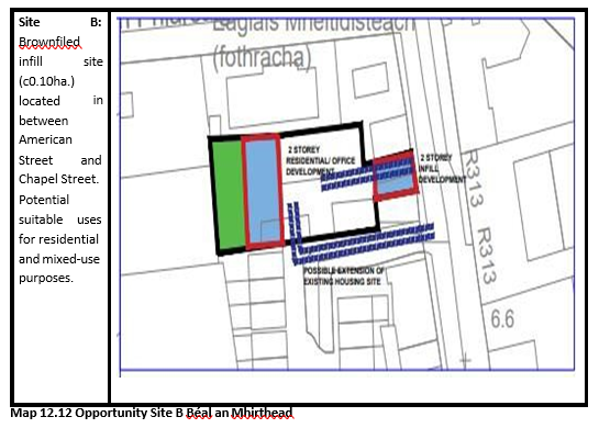
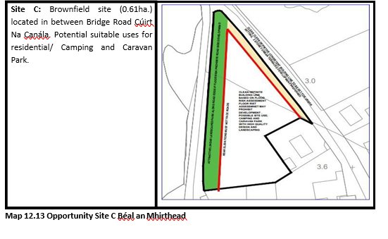
12.6.11 Town Centre Opportunity Sites (Refer to Map BT 2)
To actively progress town centre regeneration, three Town Centre Opportunity Sites have been identified for comprehensive redevelopment or refurbishment of existing brownfield/infill lands over the lifetime of the plan. The redevelopment of these sites presents an opportunity to contribute to Béal an Mhuirthead’s rejuvenation and revitalisation and to the overall improvement of the public realm and visual amenity of the area. An indicative framework has been provided to guide the appropriate development of each site.
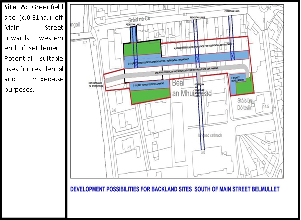
Map 12.11 Opportunity Site A Béal an Mhuirthead
|
Béal an Mhuirthead Settlement Plan Policies |
|
|
BTP 1 |
To promote the development of Béal an Mhuiread as a driver of economic growth for the Erris region and fulfil its role as a designated Self-Sustaining Growth Town. |
|
BTP 2 |
To strengthen and protect the linguistic heritage of the town and to promote use of the Irish language in the public realm through signage and other measures throughout the town centre area. |
|
BTP 3 |
To support the provision of a swimming pool in Béal an Mhuirthead through public private partnership, assistance to a private promoter or any other means. |
|
BTP 4 |
To support community-led development, where appropriate, including the implementation of Community Futures Action Plan for Belmullet (2019-2024) or any amended or superseding Community Futures Plan for the town. |
|
BTP 5 |
To support, where appropriate, proposals for the enhancement of the public realm within the town core. |
|
Béal an Mhuirthead Settlement Plan Objectives |
|
|
BTO 1 |
To work with local agencies, in particular Údarás na Gaeltachta, to encourage the development and growth of Béal an Mhuirthead as an employment centre for the wider rural area. |
|
BTO 2 |
To prioritise the construction of a civic amenity site in Béal an Mhuirthead. |
|
BTO 3 |
To create a more pedestrian friendly environment in the town centre of Béal an Mhuirthead. |
|
BTO 4 |
To support and facilitate the development of the three identified Town Centre Opportunity Sites in Béal an Mhuirthead for appropriate uses, as outlined in Section 12.6.11, and as generally permitted on Town Centre Opportunity Sites in the Land Use Zoning Matrix (Refer to Map BT 2). |
|
BTO 5 |
To encourage development in the town of Béal an Mhuirthead in accordance with the Land Use Zoning Map. |
|
BTO 6 |
To encourage and facilitate the re-use and regeneration of derelict land and buildings for retail and other town centre uses with due cognisance to the Sequential Approach prescribed in the Retail Planning Guidelines 2012. |
|
BTO 7 |
To use active land management measures, such as the vacant site levy and derelict site levy to ensure the delivery of the projected housing units for Béal an Mhuirthead, as set out in the Core Strategy, on Town Centre Opportunity Sites and residential zoned lands. |
12.7 Claremorris (Tier II)
12.7.1 Location and Context
Claremorris is located in southeast Mayo at the intersection of the N17 and N60 national routes and within close proximity to a number of large urban centres such as Castlebar, Ballinrobe, Ballyhaunis and Tuam. The town also lies on the Dublin-Westport railway line and provides a wide range of services and amenities to a significant rural hinterland.
The population of Claremorris has nearly doubled in size (92%) over the last twenty years, from 1,914 persons in 1996 (Census figures) to 3,687 persons in 2016 (Census figures). Claremorris is the 4th largest settlement in Mayo, the 18th largest in the Western Region and the 108th largest in the state. According to POWCAR 2016, the total number of jobs located within Claremorris was 1,411. The Claremorris labour catchment is the 19th largest labour catchment in the Western Region with a resident ‘at work’ population of 2,871 and a job to work ratio of 0.906.
12.7.2 Historical Context and Settlement Form
The town was founded during the late 17th century and early 18th century. The basic linear pattern of the town with its distinctive market square around which the town has grown was already established by the late eighteenth century. The opening of the railway in 1863 strengthened the role of Claremorris and the railway heritage of this era is a distinctive feature of the town.
12.7.3 Function and Vision
Claremorris is located in the Claremorris–Swinford Municipal District. The town is recognised as the main service centre in the southeast of the county and is therefore an important economic driver for the region. Mayo County Council promotes the consolidation of growth within the established footprint of the town in conjunction with regeneration, public realm enhancement, while supporting local employment and the expansion of services to meet the needs of residents and visitors. It is envisioned that Claremorris, along with the Ballyhaunis and Ballinrobe can form a Growth Cluster in South Mayo to harness their combined strengths to contribute towards the consolidation of the Atlantic Economic Corridor.
12.7.4 Economic Development
The main employment sectors in the town according to Census 2016 (POWCAR) is the Services Sector (28.6%), followed by Education, Human Health and Social Work (23.2%) and Manufacturing Industries (12.9%). The town is well served in terms of convenience and comparison shopping, with three of the major supermarket chains located in or close to the town centre. There are two retail parks located along the old Ballindine Road. Potential exists in the town centre in the form of appropriately located undeveloped lands, to further enhance the convenience and comparison retail offer.
12.7.5 Social Infrastructure
Claremorris serves as the retail centre and employment base for a larger rural catchment area and provides a range of services, social amenities and community facilities, including a hotel, library, swimming pool, Town Hall, two national schools, two secondary schools and numerous sporting and social clubs. Located to the south of the town are the Clare and Mayfield Loughs and the looped walk at McMahon Park, which constitute valuable natural amenities and visitor attractions for the town.
12.7.6 Physical Infrastructure
Claremorris is served by the N17 and N60 national routes and has direct rail links to Dublin, and a potential future rail links along the Western Rail Corridor. It is located within a thirty-minute drive of Ireland West Airport Knock and has fibre optic broadband infrastructure (Metropolitan Area Network) available. Claremorris is served by an existing municipal wastewater treatment plant (5,333PE) and has a water supply from the Lough Mask regional water supply scheme. Works by Irish Water to increase the capacity of the municipal wastewater treatment plant (7,900PE) are expected to be completed in 2023, which will provide sufficient capacity for the projected population increase, as set out in the Core Strategy.
12.7.7 Heritage and Tourism
The built heritage of the town is best reflected in the linear street pattern leading to the central square which gives the town its market town atmosphere. There are a number of protected structures (RPS) and historic structures of significance (NIAH) in the town, which greatly contribute to the urban structure and sense of place in the town. The recent development of McMahon Park Loop Walk around Mayfield and Clare Loughs has significantly enhanced the public amenity provision in Claremorris. These amenities have greatly increased the public awareness of the high-quality natural environment and biodiversity that exists on the edges of the urban core. Habitat mapping and a local Biodiversity Action Plan have been completed for Claremorris, which identifies areas of local biodiversity importance in the town.
The attractiveness and potential of Claremorris as a standalone tourist destination and as a base from which to further explore the wider region has developed significantly in the recent years. The recently constructed hotels in the town and the development of the McMahon Loop Walk have been a success in attracting visitors and raising the tourism profile of Claremorris and this strategy aims to consolidate and build on this success.
12.7.8 Sustainable Communities
Claremorris provides an attractive place to live, and is rich in heritage, natural beauty and amenity. The town plays an important economic, social and cultural role for the inhabitants of the town itself and the wider hinterland. The town also has good community stakeholder engagement and an active Tidy Towns committee. The Plan supports Claremorris’s transition to a low carbon town, noting that a community-led project by the Claremorris and Western District Energy Co-Operative, were successful in obtaining planning and financial support for a solar renewable energy project at Streamstown, Claremorris. The cooperative, which is focused on developing renewable energy projects, is a member of Community Power, Ireland’s first community-owned renewable electricity supplier. To help create sustainable communities, a strong emphasis is placed on building communities with a high standard of design, the principles of place-making, green infrastructure, permeability and connectivity, alongside the integration of community and recreation facilities. In this regard, a number of Town Centre Opportunity Sites have been identified to encourage development within the town centre.
12.7.9 Sustainable Travel
The number of people who walk to their place of work, study and other services in town is above the national average (9.3%). According to 2016 POWCAR, 15.71% of the daily population walk. However, use of cycling as a sustainable mode of travel is less than 1%, compared to the national average (3%). Therefore, Mayo County Council promotes and supports the development of public transport initiatives, in keeping with the principles of Smarter Travel. Increasing the usage of cycling in the town will require further study (audit), including the provision of new or retrofitted infrastructure and adherence to DMURS guidance standards.
12.7.10 Placemaking and Regeneration
Claremorris provides the focus for a wide range of activities that contribute to a sense of place and identity. Public realm enhancement works to the Town Square in the form of paving, planting and street furniture have greatly increased the attractiveness of the town centre. Further public realm enhancement works to the urban fabric of the town centre will be explored over the plan period. A main priority of the plan is the consolidation, rejuvenation and repopulation of the town centre, which in turn will support local businesses. Central to the physical and social regeneration of the town centre is the development of Town Centre Opportunity Sites. The Plan also includes provisions to encourage the redevelopment of derelict sites and buildings in disrepair on the approaches to the town centre, in particular on Mount Street and James Street.
12.7.11 Town Centre Opportunity Sites (Refer to Map CM 2)
Four Town Centre Opportunity Sites have been identified for comprehensive redevelopment or refurbishment over the lifetime of the plan. The redevelopment of these sites presents an opportunity to contribute to Claremorris’s rejuvenation and revitalisation and to the overall improvement of the public realm and visual amenity. An indicative framework has been provided to guide the appropriate development of each site.
Site A: Lands west of Western Rail Corridor
Site B: Lands east of Western Rail Corridor
Site C: Lands at junction of Station Road and New Link Road
Site D: Lands on new link road and to the rear of Mount Street
Site E: Lands rear of Dalton Street.
Site F: Lands between Mount Street and Dalton Street.
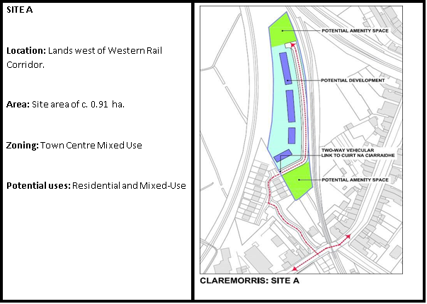
Map 12.14 Opportunity Site A Claremorris
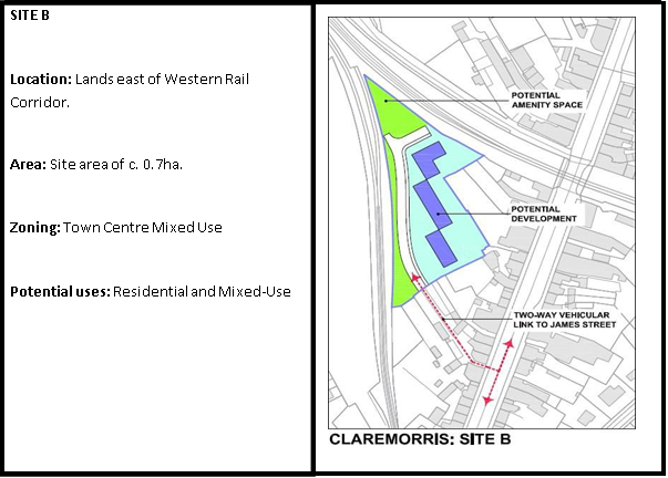
Map 12.15 Opportunity Site B Claremorris
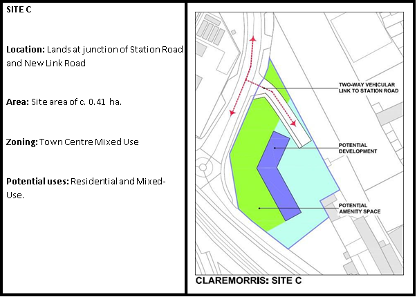
Map 12.16 Opportunity Site C Claremorris
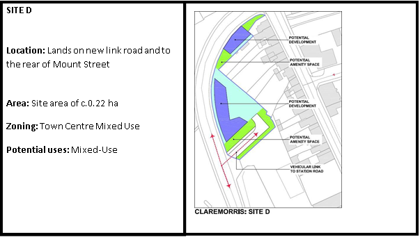
Map 12.17 Opportunity Site D Claremorris
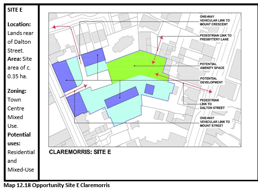
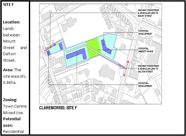
Map 12.19 Opportunity Site F Claremorris
|
Claremorris Settlement Plan Policies |
|
|
CMP 1 |
To promote the development of Claremorris as a driver of economic growth for the southeast region and fulfil its role as a designated Self-Sustaining Growth Town and to further investigate the potential for the creation of an Economic Growth Cluster in tandem with the towns of Ballinrobe and Ballyhaunis. |
|
CMP 2 |
To support and promote the development potential of Claremorris as a transportation hub given its trans-nodal infrastructural location and siting along the Atlantic Economic Corridor. |
|
CMP 3 |
To support the reinstatement of the Western Rail Corridor, in particular to actively seek and promote the re-opening of the Claremorris-Galway rail link as well as a link to Sligo; and to safeguard and protect these potential rail links from redevelopment for non- transport related purposes, in order not to preclude their future uses as an operational transportation network. |
|
CMP 4 |
To support the development of Claremorris station for passenger and freight services and as a distribution depot. |
|
CMP 5 |
To support and develop Claremorris as a low carbon town, in conjunction with relevant stakeholders, including Claremorris and Western District Energy Co-Operative. |
|
Claremorris Settlement Plan Objectives |
|
|
CMO 1 |
To develop an attractive, serviced industrial land bank to the north of the inner relief road, on lands zoned for industrial development suitable for a range of high class and environmentally acceptable business and technology/industrial park type developments. |
|
CMO 2 |
To continue to facilitate the further development of the Mayfield Lough and McMahon Park as an amenity / recreation area in Claremorris. |
|
CMO 3 |
To support and facilitate the development of the six identified Town Centre Opportunity Sites in Claremorris for appropriate uses, as outlined in Section 12.7.11, and as generally permitted on Town Centre Opportunity Sites in the Land Use Zoning Matrix (Refer to Map CM 2). |
|
CMO 4 |
To provide a civic amenity facility in Claremorris. |
|
CMO 5 |
To examine the feasibility of, with the aim of constructing, the following road projects within the plan area:
|
|
CMO 6 |
To safeguard and protect the Claremorris By-Pass from development for non- infrastructure related purposes that would prejudice its future use as part of the Western Infrastructural Corridor. |
|
CMO 7 |
To protect, maintain and enhance, in conjunction with the relevant agencies, the conservation value of Mayfield and Clare Loughs, their associated wetland habitats and rich diversity of plant and animal species and the extent, quality and connectivity of associated surface waters and wetlands as well as to promote the educational role of the lakes. |
|
CMO 8 |
To protect and enhance the conservation value of the disused railway lines in the town and their setting / margins as wildlife habitats and corridors notwithstanding that such disused railway lines may be developed at some future date as part of the County’s infrastructure / greenway network, in a manner that has regard to their inherent conservation value. |
|
CMO 9 |
To comply with the requirements of the objectives in the Economic Development Chapter of this Plan regarding Seveso II site ‘Calor Gas Teo’. |
|
CMO 10 |
To encourage development in the town of Claremorris in accordance with the Land Use Zoning Map. |
|
CMO 11 |
To encourage and facilitate the re-use and regeneration of derelict land and buildings for retail and other town centre uses with due cognisance to the Sequential Approach prescribed in the Retail Planning Guidelines 2012. |
|
CMO 12 |
To use active land management measures, such as the vacant site levy and derelict site levy to ensure the delivery of the projected housing units for Claremorris, as set out in the Core Strategy, on Town Centre Opportunity Sites and residential zoned lands. |
12.8 Swinford (Tier II)
12.8.1 Location and Context
Swinford is located in east Mayo adjacent to the intersection of the N5 and N26 national routes, on a tributary of the River Moy, the Derryonan River which runs through the town. The N5 lies to the south and the N26 runs through the centre and the town is located less than 30km northeast and southeast of Castlebar and Ballina, respectively. Swinford is located along the disused Western Rail Corridor.
The population of Swinford has marginally increased over the last twenty years, from 1,386 persons in 1996 (Census figures) to 1,394 persons in 2016 (Census figures). Nevertheless, the population of the town has decreased by 7% since 2006, when the population stood at 1,507 persons (Census figures). The population of the town is the 7th largest settlement in Mayo, the 43rd largest in the Western Region and the 217th largest in the state. According to POWCAR 2016, the total number of jobs located within Swinford was 926. The Swinford labour catchment is the 37th largest labour catchment in the Western Region with a resident ‘at work’ population of 1,118 and a job to work ratio of 2.332.
12.8.2 History and Settlement Form
The origin of Swinford is attributed to a ford crossing the river. The present-day settlement form is attributed to the Brabazon family, who planned the town on their estate. The demesne known as Brabazon Woods is part of the original estate and is a popular amenity in the town. The opening of the railway in the late 19th century strengthened the role of Swinford and the railway heritage of this era is a distinct feature of the town. The urban fabric of Swinford is historically rich, including key buildings which have been conserved and maintained for modern uses.
12.8.3 Function and Vision
Swinford is located in the Claremorris–Swinford Municipal District. The town is the established administrative, commercial and service centre for a considerable hinterland in this part of the county. There are a number of significant employers in the public and private sector, including in the areas of healthcare and pharmaceuticals. Mayo County Council promotes the consolidation of growth within the established footprint of the town in conjunction with regeneration, public realm enhancement, while supporting local employment and the expansion of services to meet the needs of residents and visitors. Opportunities exists for Swinford to develop in a sustainable manner by reason of its close proximity to Ireland West Airport Knock and its location within the Atlantic Economic Corridor region.
12.8.4 Economic Development
The largest employment sector in the Swinford labour catchment according to the Census 2016 is the Services Sector (34.6%), followed by Education, Human Health and Social Work (25.8%), ICT and Professional Services (14.2%) and Manufacturing Industries (11.9%). The town is well served in terms of convenience and comparison shopping with a major supermarket chain located on the southern edge of the town centre, a smaller supermarket in the town centre and a variety of independent traders in the town core. There is a Chamber of Commerce in Swinford who actively work towards the long-term sustainability of local business growth and development of the local economy in thetown.
Mayo County Council and the Western Development Commission (WDC) are working in collaboration to deliver “DigiWest”, a rural digital working hub network. The Council have selected the former courthouse in Swinford as the first digital hub under this project, with funding under the RRDF. The aim of this hub network is to provide a resource to local entrepreneurs, workers and communities in providing workspace with high-speed telecommunications capacity along the AEC.
12.8.5 Social Infrastructure
Swinford is the retail centre and employment base for a larger rural catchment area and provides a range of services, social amenities and community facilities. These include a library, District Garda Headquarters, a district hospital, a post office, medical centres, a cultural centre, pre-school, primary school, secondary school, churches, banks, a Credit Union, enterprise centre, retail shops, public houses and a hotel. Swinford has numerous social and sporting clubs, amenity walks and a golf course.
12.8.6 Physical Infrastructure
Swinford is served by the N5 and N26 national roads. The town also has direct bus links to Dublin, is located within fifteen-minute drive of Ireland West Airport Knock and has VDSLC broadband (Very high-speed Digital Subscriber Line) available. Swinford is served by an existing municipal wastewater treatment plant (6,500PE) and a public water supply sourced from the Carrowcanada Spring. There is sufficient capacity in this infrastructure to cater for the projected population increase as set out in the Core Strategy. Swinford has been selected as a location for the provision of free outdoor public Wi-Fi hotspots under the European Commission Wifi4EU scheme. This will provide free Wi-Fi for visitors and local residents in the town and hinterland, helping to bring about a digitally connected Mayo.
12.8.7 Heritage and Tourism
There are a number of protected structures (RPS) and historic structures of significance in the town, which greatly contribute to the urban structure and sense of place. The protection, promotion and enhancement of the built and natural heritage of the town and its immediate environs is promoted in this plan. This includes the enhancement of features and areas considered unique and important and the protection of watercourses, while enhancing the accessibility and amenity value of same. These are measures which will also increase the tourist potential of the area. Mayo County Council have also identified local biodiversity areas in Swinford and have recently prepared a Local Biodiversity Area Plan for the town.
Swinford is renowned for its fishing waters in particular the Callow lakes which yield excellent brown trout. Pony trekking and nature walks are among the many activities on offer to the visitor, along with a wealth of archaeological sites within walking distance. The Brabazon Woodlands is an important amenity for the residents and visitors to the town.
12.8.8 Sustainable Communities
Swinford provides an attractive place to live, is rich in heritage, natural beauty and amenity. The town plays an important economic, social and cultural role for the inhabitants of the town itself and the wider hinterland. Swinford has an active Town Towns committee and many other organisations that contribute to the community of the town. The Plan supports community-led initiatives to transition to a low carbon town, including the formation of community power company, similar to Claremorris. To help create sustainable communities, a strong emphasis is placed on building communities with a high standard of design, on the principles of place-making, green infrastructure, permeability and connectivity alongside the integration of community and recreation facilities and supporting community-led projects. In this regard, a number of Town Centre Opportunity Sites have been identified to encourage development within the town centre.
12.8.9 Sustainable Travel
The number of people who walk to their place of work, study and other services in town is below the national average (9.3%). According to 2016 POWCAR, 8.53% of the daily population walk. However, use of cycling as a sustainable mode of travel is less than 1%, compared to the national average (3%). In terms of public transport, 8.47% of people use the bus daily, which is above the national average (5.9%). Therefore, Mayo County Council promotes and supports the development of public transport initiatives, in keeping with the principles of Smarter Travel. Increasing the usage of cycling in the town will require further study (audit), including the provision of new or retrofitted infrastructure and adherence to DMURS guidance standards.
12.8.10 Placemaking and Regeneration
The historically rich urban fabric in the centre of Swinford defines the existing character of the town, with wide main streets and an abundance of impressive two and three storey buildings, albeit with significant levels of vacancy and dereliction. The vernacular architecture makes a strong contribution to the character of the streetscapes and adds to a sense of place in the town. An objective of this plan is the preparation of a public realm plan for Swinford over the lifetime of theplan.
A main priority of the plan is the sympathetic regeneration and reoccupation of the derelict sites and buildings in the town centre. Mayo County Council maintains a live GIS database of all vacant and derelict buildings in Swinford and will work with key stakeholders to actively tackle vacancy and dereliction, including through active land management options. In 2015, the Swinford Urban Regeneration Study was carried out by the Council, which identified key regeneration sites in the town centre area. These sites have been incorporated as Town Centre Opportunity Sites of this plan.
12.8.11 Town Centre Opportunity Sites (Refer to Map SD 2)
Six Town Centre Opportunity Sites have been identified for comprehensive redevelopment or refurbishment over the lifetime of the plan. The redevelopment of these sites presents a significant opportunity to rejuvenate and revitalise Swinford town centre and make it desirable to live, work and invest. An indicative framework has been provided to guide the appropriate development of each site.
Site A: Lands abutting Glebe House off Main Street
Site B: Part of rear garden of Glebe House
Site C: Lands off Station Road adjoining the WRC
Site D: Lands off Brookfield Avenue
Site E: Lands off Brookfield Avenue and Rivergarden.
Site F: Pound Lane
Site G: Station Road
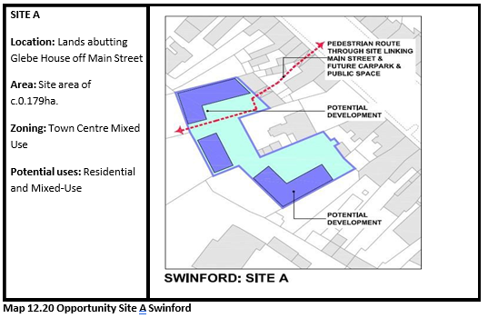
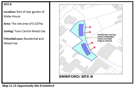
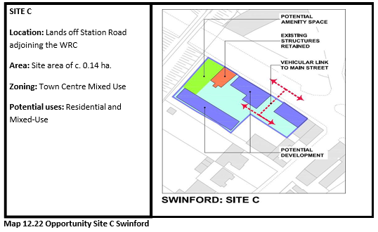
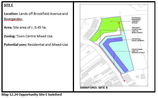
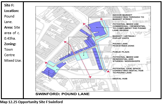
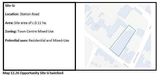
|
Swinford Settlement Plan Policies |
|
|
SDP 1 |
To promote the development of Swinford as a driver of economic growth for the east region of Mayo and fulfil its role as a designated Self-Sustaining Growth Town. |
|
SDP 2 |
To support and promote the reinstatement of the Western Rail Corridor. |
|
SDP 3 |
To support community-led developments, where appropriate, including the implementation of Community Futures Action Plan for Swinford (2013-2018) or any amended or superseding Community Futures Plan for the town. |
|
Swinford Settlement Plan Objectives |
|
|
SDO 1 |
To protect and enhance existing amenity facilities in Swinford, particularly the golf course, tennis courts, Amenity Park and Brabazon Woods. |
|
SDO 2 |
To protect and enhance areas considered unique and important in the town such as the Courthouse, the Famine Graveyard and Church of Ireland Graveyard, the Church, the Railway Bridge, the Signal Box and the Water Tower. |
|
SDO 3 |
To support and facilitate the development of the six identified Town Centre Opportunity Sites in Swinford for appropriate uses, as outlined in Section 12.8.11, and as generally permitted on town centre Opportunity Sites in the Land Use Zoning Matrix (Refer to Map SD 2). |
|
SDO 4 |
To develop the local economy by encouraging additional healthcare and pharmaceutical industries in the town and to promote the clustering of such industries on suitably zoned land. |
|
SDO 5 |
To ensure infill development respects the unique height-to-ratio building design in Swinford town centre along Market Street and Main Street. |
|
SDO 6 |
To protect the Spaddagh and Derryronan Rivers and all water courses and surface waters within the area, their water quality, ecology and function as ecological corridors, in this regard developers are required to show that any proposed development in the town will not adversely affect the integrity of the River Moy candidate Special Area of Conservation. |
|
SDO 7 |
To develop and maintain a pedestrian access to Pound Street car park from the town centre. |
|
SDO 8 |
To examine the feasibility of enhancing the link between the town centre and the Tesco development site. |
|
SDO 9 |
To support and facilitate the local community in measures to commemorate Swinford 2050 including oak tree planting on site to the rear of the former vocational school. |
|
SDO 10 |
To encourage development in the town of Swinford in accordance with the Land Use Zoning Map. |
|
SDO 11 |
To encourage and facilitate the re-use and regeneration of derelict land and buildings for retail and other town centre uses with due cognisance to the Sequential Approach prescribed in the Retail Planning Guidelines 2012. |
|
SDO 12 |
To use active land management measures, such as the vacant site levy and derelict site levy to ensure the delivery of the projected housing units for Swinford, as set out in the Core Strategy, on Town Centre Opportunity Sites and residential zoned lands (Refer to Map SD 2). |
|
SDO 13 |
To develop and maintain a civic and parking area on the infill lands located between Main Street, St Ita’s Terrace and Circular Road and to establish an appropriate traffic management plan to allow access from Main Street, Market Street and Circular Road. |
12.9 Balla (Tier III)
12.9.1 Location and Context
The town of Balla is located on the N60 national route, approximately 13km southeast of Castlebar and northwest of Claremorris. Balla is the 14th largest settlement in Mayo. The population of the town has more than doubled (143%) over the last twenty years, from 316 persons in 1996 (Census figures) to 769 persons in 2016 (Census figures). The focus of the settlement plan is to encourage job creation and population growth within the built-up footprint of the town, combined with service provision and attracting investment into the town.
12.9.2 Historical Context and Settlement Form
Balla was originally known as Ros-Dairbhreach, the Oak Grove, and got its present name in the 7th Century from its association with St. Cronin. The town has developed north of the railway line and station in a linear form along the N60, with one wide main street and a local road providing access east of Main Street. Balla maintains a village character, however, there have been a number of housing developments constructed on the northern outskirts of the town, towards Castlebar. The structure of the town is well defined, with retail and commercial uses primarily located within its town core. Housing developments have been constructed along ‘an Straid Mhor’ Road beside St. Cronans Church and Balla primary school and an opportunity exists to consolidate development, by strengthening physical linkages between existing residential areas and the town centre and encouraging infill development, over the shop development, redevelopment, or occupancy of vacant properties.
12.9.3 Function and Vision
Balla is located in the Castlebar Municipal District and functions primarily as a commuter town for larger urban centres, particularly Castlebar, which has influenced its rate of expansion. Balla provides a range of services and facilities to meet the daily needs of the local population. Consolidated growth within the development footprint, regeneration, supporting local employment, expansion of services to meet the needs of residents and visitors, together with measures to visually enhance the public realm will be key in realising the potential of Balla as a Tier III Self-Sustaining Town.
12.9.4 Economic Development
Balla provides a range of medium to small retail outlets, as well as public houses and restaurants. Balla Mushrooms is a large-scale mushroom producer and employer in the area, while Balla Livestock Mart is located north of the town along the N60 attracting farmers into the town. Opportunities exist for the town to enhance its retail offer and the Council will look favourably upon the re-use of existing, vacant buildings in the town core for appropriate uses, such as local level convenience shopping in the town.
12.9.5 Social Infrastructure
Balla provides a range of services, social and community facilities, including a post office, pre-school, primary school, secondary school, community centre, parish hall, church, salons, a pharmacy, medical centre, community centre, retail outlets, restaurants and public houses.
Balla also has numerous community groups, a strong community council and Tidy Towns committee and has benefited from the Community Futures Action Planning Process. South West Mayo Development Company is located in Balla and has developed numerous community-based programmes for the town. Balla won the national Pride of Place award in the 300-1000 population category in 2018. It is home to numerous sporting and social clubs along with recreational facilities. Sports and recreational facilities in the town include the town park, the GAA club, golf course with pitch and putt and children’s playground.
12.9.6 Physical Infrastructure
Balla is located on the N60, which directly connects the town to the large urban centres of Castlebar and Ballina. The town is served by an existing municipal wastewater treatment plant (1,200PE) and a water supply from the Lough Mask Regional Public Water Scheme. There is sufficient capacity in this infrastructure to accommodate additional population increases in the town over the plan period. The town has high speed broadband and has been selected as a location for the provision of free outdoor public Wi-Fi hotspots under the European Commission Wifi4EU scheme. This will provide free Wi-Fi for visitors and residents in the town and hinterland, helping to bring about a digitally connected Mayo.
12.9.7 Heritage and Tourism
Balla’s built heritage consists of its planned form, protected structures (2), record monuments (12) and local vernacular buildings, all of which are reflective of the historical development, sense of place and character of the town. Mayo County Council has identified ‘Local Biodiversity Areas’ in the town, which includes a strategy for the management of local biodiversity. The Balla Tower is one the main tourist assets in the town. The town park is another amenity available to residents and visitors alike. Balla is a base for many of Mayo’s tourist assets and products, with the Balla Tower to Ballintubber Walk forming part of the Croagh Patrick Heritage Trail.
12.9.8 Sustainable Communities
Balla provides an attractive place to live and is rich in heritage and amenity. Community development is a core ethos amongst residents and there are many community organisations and groups which deliver programmes to enhance the town as a place to live and visit, for example a Community Futures Action Plan (2017 -2022) has been prepared for the town. Balla is located along the main daily bus route between Castlebar and Galway. A local community bus service operated by the Mayo Local Link also serves the town and the surrounding hinterlands. The County Council is keen to promote and support the development of public transport initiatives in keeping with the principles of Smarter Travel.
The development strategy for Balla is to facilitate compact growth and re-populate the town core, together with providing a viable alternative to single rural housing within the surrounding countryside. New residential development will focus on compact growth to encourage a modal shift to more sustainable modes of transport such as walking and cycling. Stronger connections andlinkagesbetween residential settlements and the town centre is important in ensuring sustainable communities. A strong emphasis will be placed on the principles of green infrastructure, permeability and connectivity, alongside the integration of community and recreation facilities to assist with developing sustainable communities. It is necessary to consolidate and ensure the delivery of sustainable communities in Balla by accommodation a mix of housing types, densities, tenure and a high standard of design.
12.9.9 Placemaking and Regeneration
Balla is an attractive town with a village ethos. The Town Park, Balla Round Tower and Fair Green are significant amenity assets in the town and contribute to sense of place for the town. The disused water tower south of St. Cronan’s Church is a landmark structure. The "Dawn Oak 2000" project took place to mark the Millennium where 2000 oak trees were planted, creating a new wood in the town park. Balla provides the focus for a wide range of activities that contribute to a sense of place and identity, including tidy towns, village enhancement programmes and ‘pride of place’. The town plays an important economic, social and cultural role. It is a priority to consolidate the existing centre and support existing businesses and activities, in order to maintain vibrancy. There is potential for regeneration of under-utilised lands, vacant sites and buildings within the existing built- up footprint of Balla, which will assist in revitalising and repopulating the town centre. Enhancement works comprising of paving, upgrading of pedestrian footpaths and crossings will enhance the attractive, traditional character of Balla.
12.9.10 Opportunity Sites
Two Opportunity Sites have been identified for Balla (Refer to Map):
Opportunity Site 1
Northern end of Elm Gardens Road to the east of Balla town centre.
Opportunity Site 2
Southern end of Elm Gardens Road to the east of Balla town centre.
These opportunity sites have been identified in Balla for residential purposes to further contribute to the rejuvenation and revitalisation close to and within the town centre. Proposals for development within the opportunity sites should be accompanied by a site brief and should comply with national guidelines that seek to achieve sustainable compact development and to integrate principles of good urban design and placemaking.
|
Balla Settlement Plan Policies |
|
|
BAP 1 |
To support community-led developments, where appropriate, including the implementation of the Community Futures Action Plan for Balla (2017-2022) or any amended or superseding Community Futures Plan for the town. |
|
|
Balla Settlement Plan Objectives |
|
BAO 1 |
To protect and enhance existing amenity areas/facilities in Balla, particularly the round tower, fair green, town park, and its sporting and recreational facilities. |
|
BAO 2 |
To protect the town park and encourage its enhancement through the Neighbourwood Scheme (2017). |
|
BAO 3 |
To support and facilitate pedestrian mobility and safety in the town by introducing traffic calming measures and pedestrian crossings. |
|
BAO 4 |
To encourage and facilitate the re-use and regeneration of derelict land and buildings for retail and other town centre uses with due cognisance to the Sequential Approach prescribed in the Retail Planning Guidelines 2012. |
|
BAO 5 |
To support and facilitate the development of the two identified Opportunity Sites in Balla for residential development, as outlined in Section 12.9.10 (Refer to Map). |
12.10 Charlestown (Tier III)
12.10.1 Location and Context
Charlestown is located in northeast Mayo, adjacent to the N17 and N5 national routes and on the Mayo/Sligo border. It is situated approximately 50km northeast of Castlebar, approximately 9km north of Ireland West Airport Knock (IWAK) and is linked to Bellaghy to the north, which is in County Sligo. Charlestown is the 11th largest settlement in Mayo; however, this figure includes Bellaghy. The Charlestown labour catchment has a resident ‘at work’ population of 962, and a job to work ratio of 0.739. The population of the town has significantly increased (53%) over the last twenty years, from 675 persons in 1996 (Census figures) to 1,033 persons in 2016 (Census figures). The focus of the settlement plan is encouraging job creation and population growth within the built-up footprint of the town, combined with service provision and attracting investment into the town.
12.10.2 Historical Context and Settlement Form
Charlestown is the youngest town in County Mayo and dates back to 1846 when the first house was built on what was previously bog with stepping-stones to the town of Bellaghy. The town is a planned town with wide streets and a central location for trading. The River Mullaghanoe is located on the western boundary of the town, which has developed to the east of the river. The structure of the town is well defined, with retail and commercial uses primarily located within its town core, and educational and other community uses generally on the outskirts.
12.10.3 Function and Vision
Charlestown is located in the Claremorris-Swinford Municipal District. The town functions as a market town and local service centre, providing retail, residential, service and amenity functions for the local population and wider rural hinterland. The strategic location of Charlestown, along the AEC and proximity to IWAK and its economic SDZ, presents opportunities in terms of population growth, enterprise and employment opportunities. The plan supports measures to support local employment opportunities and an increase in services, together with measures to visually enhance the public realm, which will be key in realising the potential of Charlestown as a Tier III Self-Sustaining Town.
12.10.4 Economic Development
The main employment sectors in the town according to Census 2016 are Education, Human Health and Social Work (27.5%), followed by the Services Sector (24.4%), and Manufacturing Industries (13.8%). The town is well served in terms of convenience and comparison shopping, with a range of medium to small retail outlets, as well as public houses and restaurants which provide a range of employment. The Westpoint Business Centre also provides space for start-ups and enterprise hubs.
12.10.5 Social Infrastructure
Charlestown provides a range of services, social and community facilities, including a garda station, library, outdoor swimming pool, arts centre, town hall, post office, medical centre, pre-school, primary school, secondary school, Roman Catholic church, retail outlets, restaurants and public houses. Charlestown has numerous community, sporting and social clubs. Sports and recreational facilities in the town include the GAA club, Multi Use Games Area and children’s playground in the town park.
12.10.6 Physical Infrastructure
A new municipal wastewater treatment plant (3,250PE) is planned for Charlestown with an expected completion date of 2020/2021, while Charlestown’s drinking water is sourced from a well at Tombohola outside the town. The town is located along the main daily bus routes between Ballina and Dublin Airport and Galway and Derry. A local community bus service operated by the Mayo Local Link serves the town and the surrounding hinterlands. The town is located on the north-south axis of the disused Western Rail Corridor linking Mayo with Sligo. The County Council continues to promote and support the development of public transport initiatives in keeping with the principles of Smarter Travel.
12.10.7 Heritage and Tourism
Charlestown is a planned town with wide streets lending to the design and aesthetic of the town. The Mullaghanoe River is the main natural asset, which is part of the River Moy SAC. Along the river there is an informal riverside walk. Charlestown contains protected structures (2) and recorded monuments (7), which contribute to its sense of place. Knock Shrine, and Ireland West Airport Knock are in close proximity to Charlestown. Potential exists for the development of tourist accommodation for visitors travelling to and from these locations.
12.10.8 Sustainable Communities
A Community Futures Action Plan (2015-2020) has been prepared for Charlestown. The development strategy for Charlestown is to facilitate compact growth and re-population of the town core, together with providing a viable alternative to single rural housing within the surrounding countryside. Settlement patterns play a fundamental role in influencing how people travel, both the distances undertaken and the modal choice. The provision of sustainable mobility options is only realistic for the town when development patterns locate populations close to employment centres and complementary services such as education, retail, leisure and community facilities.
Stronger linkages between the existing residential settlements and the town centre are important in ensuring sustainable communities. New residential development must focus on compact growth, in order to encourage a modal shift to more sustainable modes of transport such as walking and cycling. A strong emphasis will be placed on the principles of green infrastructure, permeability and connectivity, alongside the integration of community and recreation facilities to assist with developing sustainable communities. It is necessary to consolidate and ensure the delivery of sustainable communities in Charlestown comprising of a mix of housing types, densities and tenure of a high standard of design.
12.10.9 Place Making and Regeneration
The town square area located on the junctions of the N5 and N17 routes provides the focus for a wide range of activities that contribute to a sense of place and identity. Enhancement works would revitalise the town centre and provide social and environmental benefits to the local community and visitors to the town. There is potential for better use of under-utilised lands, vacant sites and buildings within the existing built-up footprint of Charlestown to drive the delivery of quality housing, services and employment opportunities, in tandem with supporting social infrastructure. Opportunities such as the further development of the river walk along the River Mullaghanoe, protection of the handball alley and Fairgreen, and appropriate planting, paving and lighting are supported by Mayo County Council.
12.10.10 Opportunity Sites
Two Opportunity Sites have been identified for Charlestown (Refer to Map):
Opportunity Site 1
At Lavery Heights to the rear (south) of the properties on Chapel Street.
Opportunity Site 2
To the east of the existing Pine Grove estate on the southern edge of the town.
These opportunity sites have been identified in Charlestown for residential purposes to further contribute to the rejuvenation and revitalisation close to and within the town centre. Proposals for development within the opportunity sites should be accompanied by a site brief and should comply with national guidelines that seek to achieve sustainable compact development and to integrate principles of good urban design and placemaking.
|
Charlestown Settlement Plan Policies |
|
|
CNP 1 |
To support community-led developments, where appropriate, including the implementation of the Community Futures Action Plan for Charlestown (2015-2020) or any amended or superseding Community Futures Plan for the town. |
|
CNP 2 |
To promote and market Charlestown as an Enterprise Centre. |
|
CNP 3 |
To support the reinstatement of the Western Rail Corridor, in particular actively seek and promote the re-opening of the Claremorris-Galway rail link, as well as a link to Sligo and to safeguard and protect these potential rail links from redevelopment for non- transport related purposes, in order not to preclude their future uses as an operational transportation network. |
|
Charlestown Settlement Plan Objectives |
|
|
CNO 1 |
To revitalise the town centre and encourage the redevelopment of the backland areas to the rear of Church Street and Main Street where it can be demonstrated the development will not have adverse effects on the integrity of the River Moy SAC. |
|
CNO 2 |
To support and facilitate the construction of the N17 Knock to Collooney Atlantic Economic Corridor Road Project, which includes the N17 Charlestown By-pass. |
|
CNO 3 |
To protect and enhance existing amenity facilities in Charlestown, particularly the fair green, bowling alley, football pitch and the river area. |
|
CNO 4 |
To protect and enhance areas considered unique and important in the town such as the church, the library, the Arts centre, the Town Hall, the railway line and railway station, Westpoint Business Centre and the health centre. |
|
CNO 5 |
To secure sites for town centre parking. |
|
CNO 6 |
To protect the Mullaghanoe River as a salmonid status water course, and all water courses and surface waters within the area, their water quality, ecology and function as ecological corridors and as potential influences on the integrity of any Natura 2000 sites within an appropriate radial buffer zone. |
|
CNO 7 |
To continue to work and co-operate with Sligo County Council to ensure that a coherent and consistent strategy continues to be applied for the overall development of the Charlestown- Bellaghy Area. |
|
CNO 8 |
To support local sports and community groups in delivering facilities, including the delivery of a new town park on a site identified adjacent to the Church. |
|
CNO 9 |
To improve and enhance the river walkway within the town and pedestrian linkages within the town. |
|
CNO 10 |
To encourage and facilitate the re-use and regeneration of derelict land and buildings for retail and other town centre uses with due cognisance to the Sequential Approach prescribed in the Retail Planning Guidelines 2012. |
|
CNO 11 |
To support and facilitate the development of the two identified Opportunity Sites in Charlestown for residential development, as outlined in Section 12.10.10 (Refer to Map). |
12.11 Crossmolina (Tier III)
12.11.1 Location and Context
Crossmolina is situated on the Deel River, along the northern shores of Lough Conn, approximately 9 km west of Ballina. The town is located at the intersection of the N59 and the R315, a location from which there is ease of access to some of the most scenic places in Ireland, including Lough Conn, the Nephin Mountains and Ballycroy National Park. Crossmolina is the 2nd largest town in north Mayo and the 10th largest settlement in Mayo. The population of the town has marginally decreased (5.3%) over the last twenty years, from 1,103 persons in 1996 (Census figures) to 1,044 persons in 2016 (Census figures).
12.11.2 History Context and Settlement Form
Crossmolina derives its name from the Irish Crois Ui Mhaoiliona meaning “Cross of Mullany.” This name is said to be in memory of O’ Maolfhiona, a chieftain of the ancient rulers of Clan Fiachra. The parliamentary Gazetts compiled in the 1840’s refers to Crossmolina as a market and post town with a population of 1,481 persons in 1831 and 1,672 in 1841, respectively. In terms of form, the town has developed on both the eastern and western banks of the River Deel, resulting in a split urban core. The eastern banks are loosely defined by the junction of Ballina Street and Mullinamore Street and the western banks are loosely defined by the junction of Church Street and Erris Road. The street layout of Crossmolina reflects the historical pattern of growth since the early 19th century configuration. This morphology is characterised by strong built edges and varying plot widths. In more recent times, the town has expanded in a linear form, along all approach roads, but most especially along the Ballina Road.
12.11.3 Function and Vision
Crossmolina is situated within the Ballina Municipal District. The town functions primarily as a service town and provides a range of services and facilities to meet the needs of the local population. Crossmolina provides important local level retailing, social and leisure functions to the wider hinterland. The vision for Crossmolina is to enhance the level of jobs, services and residential development, through consolidated growth within the existing urban footprint. This will involve supporting regeneration of existing vacant buildings and under-utilised sites, to provide residential, local services and employment opportunities. In addition, the plan supports measures to visually enhance the public realm, the historic character and the setting of Crossmolina.
12.11.4 Economic Development
The main employment sector in Crossmolina is the service sector, in particular retail outlets. The town is well served in terms of convenience and comparison shopping, with two medium sized supermarkets located on the eastern and western sides of the River Deel. These are supplemented by a number of independent traders. Opportunities exist for the town to enhance its retail offering. In this regard, Mayo County Council will look favourably upon the re-use of existing vacant buildings in the town core for local level convenience and comparison shopping, including tourism/niche comparison outlets.
12.11.5 Social Infrastructure
Community services within and close to Crossmolina include a national school, two secondary schools. St. Tiernan’s College also provides adult education courses in the form of PLCs. Other services available in the town include a town hall, library, childcare facilities, playground, banks, post office, medical centre, tourist office, garda station and sporting and recreational facilities. In recent years there have been a number of positive developments in the town, including a new MUGA and the creation of a linear park and boardwalk along the banks of the Deel, in the town centre. There is community- built light industrial units located in proximity to the Ballina Road, one of which is currently occupied by the Real Deel Craft Brewery, a brand which is gradually raising the national profile of Crossmolina.
12.11.6 Physical Infrastructure
Crossmolina is served by the N59 and R315 road network, which directly connects the town to the large urban centres of Ballina and Castlebar. It is served by an existing municipal wastewater treatment plant (3,150PE) and a water supply from the Lough Conn and Tobermore Well and there is sufficient capacity in this infrastructure to accommodate additional population increases in the town over the plan period. The town has high speed broadband and has been selected as a location for the provision of free outdoor public Wi-Fi hotspots under the European Commission Wifi4EU scheme. This will provide free Wi-Fi for visitors and residents in the town and hinterland, helping to bring about a digitally connected Mayo. In recent times Crossmolina has come to national attention due to incidences of flooding and a Flood Relief Scheme by the OPW is currently planned for the town and will be constructed over the lifetime of the plan.
12.11.7 Heritage and Tourism
There are two protected structures in Crossmolina, namely St. Tiernan’s Church and the Church of Ireland. There are many more historic structures which contribute to the sense of place and character of the town. The town also has a rich industrial heritage as a result of its links with the former Bord na Mona peat fuelled power plant at Bellacorrick. The built heritage in the town constitutes a valuable tourist resource. In terms of natural heritage, Mayo County Council have identified Local Biodiversity Areas within the plan area of the town and have set out a strategy for management of biodiversity at a local level. The new a linear park and boardwalk along the banks of the Deel is an important, local amenity. In terms of tourism, owing to its strategic location on the River Deel, proximity to Lough Conn, the Nephin Beg Mountain range, and the Erris Peninsula, Crossmolina has considerable potential for tourism development.
12.11.8 Sustainable Communities
The compact form of the centre of Crossmolina combined with the range of retail, commercial and leisure services provided within this core, offers opportunities to accommodate the future needs of the town in a consolidated fashion. The delivery of sustainable communities will involve the re-use and regeneration of derelict and vacant buildings within the town centre and the provision of a mix of housing types and densities of high-quality design on infill and brownfield sites, moving out from the centre. Provision is made for the identification and provision of serviced sites within the town to provide opportunities for people to build their own home.
Mayo County Council supports community-led programmes, including the Crossmolina Community Action Plan (2015-2020 or any superseding version), to help meet the needs of the town and contribute to a low carbon energy efficient Crossmolina, such as community renewable energy projects, energy efficiency projects and increased usage of sustainable forms of transport. A public smart lighting and energy efficient programme was implemented in Crossmolina, through Mayo County Council and Sustainable Energy Authority Ireland, in recent years. One such project included making the Civic Centre on Mullenmore street an energy efficient building.
12.11.9 Placemaking and Regeneration
Enhancement works to the public realm in the core area of Crossmolina have the potential to contribute to the revitalisation of the core area and to provide social and environmental benefits to the local community and visitors. This is combined with policies to promote the reuse of existing derelict and vacant buildings for residential and/or commercial purposes, particularly on Mullenmore Street and Erris Street, and the identification of opportunity sites within or close to the town core, capable of accommodating residential developments of a suitable scale and density.
12.11.10 Opportunity Sites
Four Opportunity Sites have been identified for Crossmolina (Refer to Map):
Opportunity Site 1
Located to the rear (south) of the properties on Ballina Street and to the rear (east) of existing properties on Mullinmore Street.
Opportunity Site 2
Located opposite St Tiernan’s College (secondary School), at the southern end of Mullinmore Street.
Opportunity Site 3
An infill site located along “The Boreen” to the west of the Deel River.
Opportunity Site 4
Lands off The Boreen adjoining Erris Street properties to the North.
These opportunity sites have been identified in Crossmolina for residential purposes to further contribute to the rejuvenation and revitalisation close to and within the town centre. Site selection accounted for the avoidance flooding issues that currently impact the settlement and availability of services. Proposals for development within the opportunity sites should be accompanied by a site brief and should comply with national guidelines that seek to achieve sustainable compact development and to integrate principles of good urban design and placemaking.
|
Crossmolina Settlement Plan Policies |
|
|
CRP 1 |
To investigate proposals for the enhancement of the public realm within the town core. |
|
CRP 2 |
To support community-led developments, where appropriate, including the implementation of the Community Futures Action Plan for Crossmolina (2015-2020) or any amended or superseding Community Futures Plan for the town. |
|
Crossmolina Settlement Plan Objectives |
|
|
CRO 1 |
To retain and enhance the distinctive character and layout of Crossmolina town, which reflects the historical street pattern of growth since the early nineteenth century configuration and to promote this as part of the town’s unique identity. |
|
CRO 2 |
To investigate the possible designation of built-up areas of special interest and importance in the town, such as an Architectural Conservation Areas (ACA). |
|
CRO 3 |
To support the local community in exploring the creation of a Cultural and Heritage Centre in the town, as resources permit. |
|
CRO 4 |
To support and facilitate the full implementation of the Office of Public Work’s Flood Relief Scheme for Crossmolina. |
|
CRO 5 |
To sustain, enhance and consolidate the retail and services offer within the core areas of Crossmolina and harness and develop the potential of heritage and tourism assets. |
|
CRO 6 |
To encourage and facilitate the re-use and regeneration of derelict land and buildings for retail and other town centre uses with due cognisance to the Sequential Approach prescribed in the Retail Planning Guidelines 2012. |
|
CRO 7 |
To support and facilitate the development of the four identified Opportunity Sites in Crossmolina for residential development, as outlined in Section 12.11.10 (Refer to Map). |
12.12 Foxford (Tier III)
12.12.1 Location and Context
Foxford is located in north-east Mayo, at the intersection of the N26 and N58 national routes, on the River Moy, approximately 16 km south of Ballina. Foxford is the 8th largest settlement in Mayo and the population of the town has significantly increased (39.3%) over the last twenty years, from 944 persons in 1996 (Census figures) to 1,315 persons in 2016 (Census figures).
12.12.2 History and Settlement Form
Foxford is located on the site of an ancient settlement that grew around a crossing point on the River Moy. The current town dates from 1683 when John Bingham, MP for Mayo, first took out a patent for 4 fairs and a market for a new plantation of English and Scottish settlers, on the east bank of the river. This is reflected in the existing settlement form, with the town centre and commercial core located on the eastern side of the river while, west of the river is almost exclusively residential in nature. Historically Foxford is renowned as the birthplace of Admiral William Browne (1777-1859). Admiral Brown founded the Argentinian Navy and there is an exhibition centre dedicated to his life and achievements in the town today.
The modern town of Foxford is inextricably linked with and shaped by the fortunes of the Providence Woollen Mills. The Woollen Mills were the principal employer and a significant contributor to the built form, social activity and cultural aspects in the town, from the late 19th to the late 20th century. The development of the town beyond the core area in modern times has extended along the main approach roads, with housing developments located along the Ballina Road, the Swinford Road and the R318 local road, leading to the Train Station. The opening of an inner-relief road in the 2002, connecting the Swinford Road to the southern section of Main Street, has greatly lessened traffic congestion and has presented development opportunities to the rear of the commercial core.
12.12.3 Function and Vision
Foxford functions as a vibrant employment and service centre for the population of the town itself and the wider hinterland. The town draws tourists and visitors attracted by angling on the River Moy and the unique industrial heritage of the town. The vision for Foxford is to enhance the attractiveness of the town centre as aplaceto live, work and visit, while simultaneously developing the town’s heritage and tourism assets.
12.12.4 Economic Development
A former industrial town, Foxford has shifted its focus of employment to newer industries and tourism centred around the industrial heritage of the town and angling on the River Moy. Employment in Foxford is dominated by O’ Hara’s Bakery located on the western outskirts of the town. Other smaller scale employers in the town include CPAC Foods and the Foxford Woollen Mills Visitor Centre. Convenience retail in the town is catered for by two appropriately sized supermarkets in the town centre.
12.12.5 Social Infrastructure
Foxford is the retail centre and employment base for a larger, rural catchment area and provides a range of services, social amenities and community facilities, including a national and secondary school, childcare facilities, a playground, hotel, post office, leisure centre, shops, restaurants, food outlets, public houses and a range of community, voluntary, arts and sporting clubs.
12.12.6 Physical Infrastructure
Foxford is served by the N26 and N58 national road network, which directly connects the town to the large urban centres of Ballina and Castlebar, respectively. The town is served by an existing municipal wastewater treatment plant, which was recently upgraded by Irish Water to increase its capacity (1,360 PE to 3,500PE). The water supply serving the town is drawn from Lough Muck. The upgrade works to the wastewater treatment plant ensures there will be sufficient capacity to accommodate additional population increase in the town. Foxford is also served by rail and a regular bus service. Foxford experiences regular flood events in recent years and appropriate measures need to be examined to manage this flood risk for the town, in order for it to develop in a consolidated fashion.
12.12.7 Heritage and Tourism
The history and heritage of Foxford, both built and natural, are inextricably linked with the form and function of the existing settlement. There are four protected structures in Foxford, namely the Foxford bridge, St. Mary and Michael’s R.C. Church, Church of Ireland and St. Mary’s Convent. There are many other historic buildings and structures in the town, which contribute to the sense of place and character. The consolidation and revitalisation of the town core will strengthen the historic character of the town and enhance the tourist experience. The River Moy divides the town physically and attracts many visitors to the town each year. Considerable potential exists to improve access to the river within the town in conjunction with the relevant environmental agencies, thereby, building on its amenity value for both locals and visitors.
12.12.8 Sustainable Communities
The development strategy for the town is to support revitalisation and repopulation of the town centre, by encouraging the reuse of existing vacant or derelict buildings and identifying sites for new residential and/or mixed-use developments that will respect the character and form of the existing core. It is part of the strategy to identify serviced sites within the built-up footprint of the settlement, for the provision of residential development at appropriate locations. Mayo County Council supports increased cycling and walking in the town and other community-led programmes, including the Foxford Community Action Plan (or any superseding version), to meet the needs of the town and contribute to a low carbon energy efficient Foxford.
12.12.9 Placemaking and Regeneration
The placemaking strategy for Foxford builds on the way the town currently functions as both a residential settlement and as an employment and service provider, while also functioning as an attractive and unique tourist destination, centred around the natural and built environment and the industrial heritage of the town. This can be achieved by revitalising and rejuvenating the core area identification of enhancement works both centrally and beyond, designed to provide identification enhancement works both centrally and beyond, designed to provide social and environmental benefits to the local community and visitors alike. In addition, this involves the identification of opportunity sites within or close to the town core capable of accommodating residential developments of a suitable scale and density. In determining the location and extent of such sites, cognisance is taken of the flooding issues that currently impact the settlement.
12.12.10 Opportunity Sites
Five Opportunity Sites have been identified for Foxford (Refer to Map):
Opportunity Site 1
Comprises of the back lands to the rear of the existing commercial properties along Lower Main Street and is bounded by Morrogh Bernard Road.
Opportunity Site 2
Located off Morrogh Bernard Road along Admiral Brown Road and is bounded to the north by Chapel Road properties/Church.
Opportunity Site 3
Located off both Morrogh Bernard and Admiral Brown Roads and adjoins Sliabh Rua estate to the south-east.
Opportunity Site 4
Located on Chapel Street, northern boundary abuts rear boundaries of properties fronting Providence Road.
Opportunity Site 5
Located on St Patricks Terrace, western boundary adjoins Sacred Heart National School.
These sites have been identified in Foxford for residential purposes to further contribute to the rejuvenation and revitalisation close to and within the town centre. Proposals for development within the opportunity sites should be accompanied by a site brief and should comply with national guidelines that seek to achieve sustainable compact development and to integrate principles of good urban design and placemaking.
|
Foxford Settlement Plan Policies |
|
|
FDP 1 |
To investigate proposals for the enhancement of the public realm within the town core. |
|
FDP 2 |
To support community-led developments, where appropriate, including the implementation of the Community Futures Action Plan for Foxford (2017-2022) or any amended or superseding Community Futures Plan for the town. |
|
Foxford Settlement Plan Objectives |
|
|
FDO 1 |
To retain and enhance the distinctive character and layout of Foxford town, which reflects the historical street pattern of growth since the early nineteenth century configuration and to promote this as part of the town’s unique identity. |
|
FDO 2 |
To support the local community in exploring the creation of a river walk in the town, as resources permit and in a manner that will not adversely affect the integrity of the River Moy candidate Special Area of Conservation. |
|
FDO 3 |
To support the further investigation by the Office of Public Works of the necessity of a flood relief scheme for Foxford. |
|
FDO 4 |
To sustain, enhance and consolidate the retail and services offer within the core areas of Foxford and harness and develop the potential of heritage and tourism assets. |
|
FDO 5 |
To encourage and facilitate the re-use and regeneration of derelict land and buildings for retail and other town centre uses with due cognisance to the Sequential Approach prescribed in the Retail Planning Guidelines 2012. |
|
FDO 6 |
To support and facilitate the development of the five identified Opportunity Sites in Foxford for residential development, as outlined in Section 12.12.10 (Refer to Map). |
12.13 Killala (Tier III)
12.13.1 Location and Context
Killala is a coastal town in north Mayo, along the R314 regional route linking Ballina to Ballycastle. It is situated approximately 13km north of Ballina overlooking Killala Bay. Killala is the 16th largest settlement in Mayo. The population of the town has gradually decreased (14.5%) over the last twenty years, from 657 persons in 1996 (Census figures) to 562 persons in 2016 (Census figures). The focus of the settlement plan is to encourage job creation and population growth within the built-up footprint of the town, combined with increased service provision and attracting investment into thetown.
12.13.2 History Context and Settlement Form
The name Killala is derived from the Irish ‘Cill Ala’, meaning "the mottled church". The origins of Killala diocese date back to the time of St Patrick. In the year 442 AD, St Patrick appointed his disciple, St Muredach, to build a community in Killala, which has resulted in many fine archaeological sites and monuments remaining today, such as Rosserk Abbey, Moyne Abbey, Rathfran Abbey, Meelick Castle and Humberts Rock. The town is dominated by a round tower, which dates from the 12th century. The tower marks Killala’s historic distinction as an important centre of ecclesiastical politics. In the centre of the town is a Church of Ireland cathedral. It was built in 1670 immediately above the remains of an earlier Catholic cathedral. The adjoining graveyard has a 9th century “Souterrain”, an underground burial structure associated with the Atlantic Iron Age settlers. The street layout of Killala reflects its historical pattern and there are several cut-stone mill buildings which reflect its commercial past. Housing developments have been predominantly located along the approach roads to the town.
12.13.3 Function and Vision
Killala is located in the Ballina Municipal District and is designated as a Self-Sustaining Tier III town, which functions as a commuter area primarily for Ballina. It functions as an important local service centre, providing retail, residential, service and amenity functions for locals and the rural hinterlands, while supporting the upper tier towns of the Settlement Hierarchy. Opportunity exists to enhance the level of employment and services in the town, given the established employment base and capitalising on developing Killala as a tourist base for local attractions. Opportunities exist for Killala for a data centre and/or renewable energy hub at the Killala Business Park. Consolidated growth within the development footprint, regeneration, supporting local employment, the expansion of services to meet the needs of residents and visitors together, along with measures to visually protect and enhance the public realm and historic character of this settlement will be key in realising the potential of Killala as a Self-Sustaining Growth Town.
12.13.4 Economic Development
The scale and range of commercial facilities in the town make it a significant centre of services and employment for the surrounding rural hinterland. Independent traders include a butcher, a chemist, a draper, confectioners, a petrol station with convenience shop and an Aurivo agri- store. Opportunity exists for the town to enhance its retail offer and the Council will look favourably upon the re-use of existing vacant buildings in the town core for local level convenience and comparison shopping, including tourism/niche comparison outlets.
Enterprise within the town is mainly in the services and light industrial sectors. Killala Precision Components, Killala Upholstery and Killala fish factories provide employment for the town. A supportive approach shall be adopted to promote the expansion of these activities and to further local employment. The Council will support the upgrade, retrofitting and enhancement of existing buildings, particularly in the context of achieving energy efficiency and reducing carbonfootprint.
12.13.5 Social Infrastructure
Community Services within and close to Killala include a national school and a community centre. Other services available in the town include a creche, post office, medical clinic, garda station and ATM. Killala has numerous community groups and a strong community council and has benefited from the Community Futures Action Planning Process. In recent years there have been a number of positive developments in the town including a MUGA.
12.13.6 Physical Infrastructure
Killala is served by the R314 regional route which directly connects the town to Ballina. A new municipal wastewater treatment plant (3,155PE) has been operational for Killala since 2020. The new plant brings benefits to Killala, in terms of acting as a platform for social and economic development, increased population, health, integrity of the environment and improved water quality for all. Cleaner water will enhance the amenity value of the town and bay. Killala is served by the Ballina Regional Water Supply. Killala has good access to internet including broadband. The town is served by a regular daily bus service and the Council continues to promote and support the development of public transport initiatives in keeping with the principles of Smarter Travel.
12.13.7 Heritage and Tourism
Killala has a rich and diverse built heritage, containing protected structures (6); recorded monuments (10) and other historic buildings and structures, all of which contribute to a rich sense of place and character. The round tower is the most distinguishable structure of the town, by reason of its elevated location overlooking Killala Bay. Mayo County Council have completed a comprehensive analysis of the historic development of Killala, its setting and built heritage to identify the town’s unique character and recommendations on how that character can be enhanced, including the need for an ACA.
Killala, due to its location, is a popular tourist destination. Its nearest beach, Ross Beach, is a wonderfully unspoiled Blue Flag beach, which is excellent for swimming, surfing and sailing. A strong tradition of fishing prevails in the area, with Killala Harbour providing a focal point for visiting fishermen and locals alike. In addition to natural resources Killala’s built heritage constitutes a valuable tourist resource.
12.13.8 Sustainable Communities
A Community Futures Action Plan (2015-2020) has been prepared for Killala. The compact form of the centre of Killala combined with the range of retail, commercial and leisure services within the town core, afford opportunities to accommodate the future needs of the town in a consolidated fashion. The development strategy for the town aims to support revitalisation and repopulation of the town centre, by encouraging the reuse of existing vacant or derelict buildings and identifying sites for new residential and/or mixed-use developments that will respect the character and form of the existing core. It is also part of the strategy to identify serviced sites within the built-up footprint of the settlement, for the provision of residential development at appropriate locations. Stronger connections and linkages between residential areas and the town centre is important in ensuring sustainable communities and for encouraging the use of more sustainable modes of transport.
A strong emphasis will be placed on the principles of green infrastructure, permeability and connectivity, alongside the integration of community and recreation facilities to assist with developing sustainable communities. It is necessary to consolidate the town and ensure the delivery of sustainable communities in Killala, comprising of a mix of housing types, densities and tenure in conjunction with a high standard of design. Mayo County Council support sustainable transport options in the town, such as cycling and walking and community-led programmes, including the implementation of the Killala Community Action Plan (or any superseding version) to meet the needs of the town and contribute to a low carbon energy efficient town.
12.13.9 Placemaking and Regeneration
Killala is an attractive town with a historical atmosphere. The town provides the focus for a wide range of activities that contribute to a sense of place and identity. This town plays an important economic, social and cultural role and the main priority of the Plan is to consolidate the existing centre, while supporting the existing businesses and activities, in order to maintain vibrancy. A character study of the town, with potential for an ACA designation, would ensure the protection of the unique character of the town, whilst allowing new development to compliment same. Funding is secured under the 2017 Town and Village Renewal Scheme for Killala Round Tower Dereliction and Streetscape Improvements. The Plan supports the continued pursuit of all funding streams to sensitively enhance the public realm and the re-use of derelict, vacant and under-utilised lands within the built-up area of Killala.
12.13.10 Opportunity Sites
Three Opportunity Sites have been identified for Killala (Refer to Map):
Opportunity Site 1
Located at the northern edge of the plan, defined to the north by the shoreline, to the west by the R314 road, and to the east by Killala harbour.
Opportunity Site 2
Located off Courthouse Street, to the east of the soccer pitch.
Opportunity Site 3
Located to the west of the Killala plan area adjoining the plan boundary and to the east of Killala FC pitch, and to the east/north of Hillcrest.
These sites have been identified in Killala for residential purposes to further contribute to the rejuvenation and revitalisation close to and within the town centre. Proposals for development within the opportunity sites should be accompanied by a site brief and should comply with national guidelinesm that seek to achieve sustainable compact development and to integrate principles of good urban design and placemaking.
|
Killala Settlement Plan Policies |
|
|
KAP 1 |
To support appropriate enterprise/employment uses that are sympathetic to and supportive of maintaining the architectural character and setting of Killala House (a Protected Structure) and adjacent lands. |
|
KAP 2 |
To support the linkage of the Western Way with various local walking/cycling trails in the area including the Great Western Greenway. |
|
KAP 3 |
Support community-led developments, where appropriate, including the implementation of the Community Futures Action Plan for Killala (2015-2020) or any amended or superseding Community Futures Plan for the town. |
|
Killala Settlement Plan Objectives |
|
|
KAO 1 |
To work with existing service providers and relevant interests to promote Killala as one of the key tourist locations within County Mayo, in accordance with the objectives contained within this Plan. |
|
KAO 2 |
To protect and enhance the character of the pier area and to provide for the development of appropriate commercial, tourism, leisure uses and ancillary works such as car parking and navigation. |
|
KAO 3 |
To promote greater public accessibility to existing tourist attractions in the town. |
|
KAO 4 |
To investigate the provision of a bypass around the town and to improve traffic management through the provision of the inner relief road and the development of a town centre car park, subject to no significant adverse effects on the environment, including the integrity of the Natura 2000 network. |
|
KAO 5 |
To ensure that the historic architectural character of Killala is protected and enhanced. |
|
KAO 6 |
To designate within the lifetime of this plan an Architectural Conservation Area for Killala town centre including Market Street, Courthouse Street, Church Street, Steeple Hill, William Street, Georges Street, and Ballina Road (R314) and the coastline to the pier. |
|
KAO 7 |
To protect Killala Bay/Moy Estuary Special Area of Conservation (Site Code 000458) and Special Protection Area (Site Code 004036). Development proposals will be required to demonstrate that the development will not have an adverse effect on the integrity of the sites. |
|
KAO 8 |
To retain the tourist accommodation function of the holiday cottages at Steeple Hill. |
|
KAO 9 |
To encourage and facilitate the re-use and regeneration of derelict land and buildings for retail and other town centre uses with due cognisance to the Sequential Approach prescribed in the Retail Planning Guidelines 2012. |
|
KAO 10 |
To support and facilitate the development of the three identified Opportunity Sites in Killala for residential development, as outlined in Section 12.13.10 (Refer to Map). |
12.14 Kiltimagh (Tier III)
12.14.1 Location and Context
Kiltimagh is centrally located within County Mayo, approximately 20km east of Castlebar and southwest of Ireland West Airport Knock. The town is set in an elevated location, with the highest point being 70 metres above sea-level. The Sliabh Cairn Mountain range provides a backdrop from the northwest to the southwest and forms an attractive landscape setting for the town. The Pollagh, Glore and Yellow rivers, which are located in close proximity to the town provides significant natural amenities. Kiltimagh is the 9th largest settlement in Mayo. The population of the town has gradually increased (16.6%) over the last twenty years, from 917 persons in 1996 (Census figures) to 1,069 persons in 2016 (Census figures). The focus of this settlement plan to encourage job creation and population growth within the built-up footprint of the town, combined with service provision and attracting investment into the town.
12.14.2 Historical Context and Settlement Form
The town was first recorded in 1617 and the Irish place name for Kiltimagh is Coillte Mach, which translates as “the woods of Maghach”. Kiltimagh, as we know it today, developed as an artisan village around the late 19th century. The structure of the town is well-defined with retail and commercial uses primarily located within its town core, alongside enterprise and employment, institutional and community uses generally on the outskirts. Residential areas are mainly to be found to the south/southwest of the town. An opportunity exists to consolidate development by encouraging infill development, over the shop development, redevelopment and/or occupancy of vacant properties.
12.14.3 Function and Vision
Kiltimagh is located in the Claremorris-Swinford Municipal District. The town provides an important economic focus, providing retail, residential, education, service and amenity functions for locals and the wider rural hinterlands, whilst supporting the upper tier towns of the Settlement Hierarchy. The plan provides an opportunity to maximise the potential of the town’s strategic central location within the county and along the Western Rail Corridor. Consolidated growth within the development footprint, regeneration, supporting local employment and the expansion of services to meet the needs of residents and visitors, together with measures to visually enhance the public realm will be key in realising the potential of Kiltimagh as a Tier III Self-Sustaining Town.
12.14.4 Economic Development
Kiltimagh is an important local service town for the wider agricultural hinterland of the Kiltimagh area and provides a wide range of services and facilities to meet the daily needs of the local population. The town provides a range of medium to small retail and convenience outlets, hotels, public houses and restaurants, which provide an important employment base. Other notable employers include Genfitt, CMS distribution and the Cairn international trade centre. Opportunity exists for the town to enhance its retail offering, and the Council shall look favourably upon the re-use of existing vacant buildings in the town centre for local level convenience and comparison shopping, including tourism/niche comparison outlets.
12.14.5 Social Infrastructure
Kiltimagh provides a range of services, social and community facilities, including a post office, medical centre, pre-school, primary school, secondary school, parish hall, church, bank, hotels, pharmacies, museums, retail shops, restaurants, take-aways, service stations, public houses, community centre, health centre and library. Kiltimagh has numerous community, sporting and social clubs alongside recreational facilities. Sports and recreational facilities in the town include GAA facilities, approved Velo-Rail, MUGA, and children’s playground. It is also proposed to create a town amenity park to the west of the train station.
12.14.6 Physical Infrastructure
Kiltimagh is strategically located in the centre of Mayo and is served by a range of important regional routes linking the town directly to the nearby settlements of Swinford, Balla, Knock, Bohola and Kilkelly. The town is within 20-minute drive of Ireland West Airport Knock and located along the Western Rail Corridor (WRC), with potential future links to Limerick and Sligo. The town is served by an existing municipal wastewater treatment plant (3,333PE) and a water supply from the Kiltimagh Public Water Supply source from the Glore River. The town benefits from fibre optic broadband infrastructure (Metropolitan Area Network).
12.14.7 Heritage and Tourism
Kiltimagh has retained much of its 19th century features and its townscape has a distinctive character with a considerable number of Victorian buildings and artisan terraces. The town is a historic market town and is defined by Market Square and the collection of associated buildings along Main Street, Aiden Street, Chapel Street and Thomas Street. Kiltimagh contains protected structures (5), recorded monuments (8) and many other local vernacular buildings, all of which are reflective of its historical development, sense of place and character of the town. The town contains a Sculpture Park and Railway Station Museum, with a station containing on-track carriages from the WRC. Mayo County Council have identified Local Biodiversity Areas in the town and there are plans to enhance the existing Kiltimagh Amenity Park. The built and cultural heritage of Kiltimagh are key tourist attractions to the town. The development of the Velo Rail, along the WRC tracks, will attract many more recreational visitors to the town, with additional tourism opportunities if the WRC reopens for rail purposes.
12.14.8 Sustainable Communities
Kiltimagh provides an attractive place to live and is rich in heritage, natural beauty and amenity. It benefits from strong community involvement and a Community Futures Action Plan (2019-2024) has been prepared for the town. The development strategy for Kiltimagh is to support new housing and population growth, consistent with the Core Strategy. It aims to facilitate compact growth through revitalisation of the historic town core, together with providing of a mix of housing types, densities and tenure to meet the needs of Kiltimagh, as a viable alternative to single rural housing within the surrounding countryside. The town is served by a bus service between Ballina and Claremorris and other local services operated by Mayo Local Link. The County Council is keen to continue to promote and support the development of public transport initiatives in keeping with the principles of Smarter Travel.
12.14.9 Placemaking and Regeneration
Kiltimagh’s distinctive buildings, streetscape and sculptures throughout the town provide a distinctive a sense of place. In terms of placemaking, the main priority is the consolidation of the town centre, while supporting existing business in order to maintain vibrancy. Many buildings in the centre are suitable for renovation of upper storeys into residential use, while ground floors should be prioritised for commercial and community uses that activate the street, where possible. Together this will help sustain town vibrancy, including the evening economy. Another priority of the Kiltimagh Settlement Plan is the regeneration and repopulation of the town centre, through the sustainable reuse of existing buildings, focusing on dereliction and the appropriate development of infill, opportunity sites, underpinned by good urban design and placemaking principles. This will help drive the delivery of quality housing, services and employment opportunities, in tandem with supporting social infrastructure.
12.14.10 Opportunity Sites
Three Opportunity Sites have been identified for Kiltimagh (Refer to Map):
Opportunity Site 1
Located off and to the south of Clonkedagh Road.
Opportunity Site 2
Located off and to the north of Clonkedagh Road.
Opportunity Site 3
Located to the rear of the properties at the northern end of Main Street (Walshtown) and is bounded by the railway line to the east.
These opportunity sites have been identified in Kiltimagh for residential purposes to further contribute to the rejuvenation and revitalisation close to and within the town centre. Proposals for development within the opportunity sites should be accompanied by a site brief and should comply with national guidelines that seek to achieve sustainable compact development and to integrate principles of good urban design and placemaking.
|
Kiltimagh Settlement Plan Policies |
|
|
KTP 1 |
To support the reinstatement of the Western Rail Corridor, in particular actively seek and promote the re-opening of the Claremorris-Galway rail link, as well as a link to Sligo and to safeguard and protect these potential rail links from redevelopment for non-transport related purposes, in order not to preclude their future uses as an operational transportation network. |
|
KTP 2 |
To support the work of IRD Kiltimagh Ltd., in providing essential community services for the elderly and marginal groups of Kiltimagh. |
|
KTP 3 |
To support the creation of an Arts residency programme with revolving art residency spaces. |
|
KTP 4 |
To promote more frequent bus services to Kiltimagh allowing increased connectivity and accessibility for tourists and residents alike. |
|
KTP 5 |
To support community-led developments, where appropriate, including the implementation of the Community Futures Action Plan for Kiltimagh (2019-2024) or any amended or superseding Community Futures Plan for the town. |
|
Kiltimagh Settlement Plan Objectives |
|
|
KTO 1 |
To protect and enhance existing amenity facilities in Kiltimagh, particularly the Pollagh River, the playground, amenity park, GAA pitch, wetland park and sculpture trail. |
|
KTO 2 |
To protect existing public sculptures throughout the town and support the provision of additional sculptures at appropriate locations throughout the town. |
|
KTO 3 |
To support and facilitate pedestrian mobility and safety in the town by introducing traffic calming measures and pedestrian crossings. |
|
KTO 4 |
To maintain and further develop walking routes and linkages to the walking routes throughout the town. |
|
KTO 5 |
To implement effective vehicular linkages within and around the town, subject to further feasibility studies, detailed design and traffic impact assessment. |
|
KTO 6 |
To encourage and facilitate the re-use and regeneration of derelict land and buildings for retail and other town centre uses with due cognisance to the Sequential Approach prescribed in the Retail Planning Guidelines 2012. |
|
KTO 7 |
To support and facilitate the development of the three identified Opportunity Sites in Kiltimagh for residential development, as outlined in Section 12.14.10 (Refer to Map). |
12.15 Knock (Tier III)
12.15.1 Location and Context
The town of Knock is located in east Mayo and is an international place of pilgrimage and prayer where over one and a half million pilgrims visit each year. It is located approximately 11km northeast of both Claremorris and Ballyhaunis, respectively. Knock is the 13th largest settlement in Mayo. The population of the town has significantly increased (69%) over the last twenty years, from 575 persons in 1996 (Census figures) to 972 persons in 2016 (Census figures). The focus for the settlement plan is encouraging job creation and population growth within the built-up footprint of the town, combined with service provision and attracting investment into the town.
12.15.2 History Context and Settlement Form
Knock comes from the Irish word "cnoc" meaning hill, historical evidence shows the village had been named that as far back as 1625. The Irish language name was changed to "Cnoc Mhuire" meaning the hill of the Virgin Mary after the visions. Notably, its name is derived from the Knock Shrine, an approved Catholic shrine and place of pilgrimage where the faithful believe that the Blessed Virgin Mary, Saint Joseph and Saint John the Evangelist appeared on 21 August 1879. The structure of the town is well defined and consists of a linear settlement form, with housing developments located along the approach roads to the town. An opportunity exists to consolidate development by strengthening linkages between residential areas and the town centre and encouraging infill development, over the shop development, re-development or occupancy of vacant properties.
12.15.3 Function and Vision
Knock is located within the Claremorris-Swinford Municipal District. The town functions as an important economic focus, providing retail, residential, service and amenity functions for locals and the rural hinterlands, while also supporting the upper tier towns of the Settlement Hierarchy. Retail and commercial uses are primarily located within its town, with educational and community uses generally on the edge of town centre. Opportunity exists to further develop Knock as an international tourist destination in a manner that maintains and enhances the quality of life for those living, working in and visiting the town. There are further opportunities for economic development, social integration and sustainable transport options including smarter travel, whilst protecting the natural, cultural and built heritage and the environmental quality of the town.
12.15.4 Economic Development
Knock is predominantly a place of international pilgrimage and prayer and as a result has developed into a tourist town. Other forms of employment include a range of medium to small retail outlets, as well as tourist accommodation, public houses and restaurants. All of these provide important sources of employment in the town.
12.15.5 Social Infrastructure
Community services within and close to Knock include a national school and community centre. Other services include a creche, post office, medical clinic, nursing home, garda station and ATM. Knock has numerous communities, sporting and social clubs, however the town has few recreational facilities.
12.15.6 Physical Infrastructure
Knock is served by the N17, R323 and R329 road network, which directly connects the town to the large urban centres of Claremorris and Ballyhaunis. It has a regular daily bus service. The town is served by an existing municipal wastewater treatment plant (6,200PE) and a water supply from the Lough Mask Regional Water Supply Scheme. There is sufficient water service capacity to accommodate the projected additional population increases in the town over the plan period. Ireland West Airport Knock is located approximately 21km northeast of Knock village, which was originally built to bring people to the Knock Shrine.
12.15.7 Heritage and Tourism
Knock has a rich cultural heritage, which has given the town a sense of identity. It has developed into a major pilgrimage centre for national and international groups. The Knock shrine complex incorporates five churches including the Apparition Church, Parish Church, Basilica, Blessed Sacrament Chapel and Chapel of Reconciliation. Knock Shrine is the leading religious tourism destination in Ireland and in Western Europe. It is the second largest Marian Shrine in the world and surpasses all Fáilte Ireland destination sites at a national level in terms of footfall, attracting one and a half million tourists annually. The potential role of religious/pilgrimage tourism is significant in view of the number of the iconic sites at Knock Shrine. There is therefore significant potential for harnessing this footfall to the wider county and region, by way of creative exploration of and interlinking to a range of complementary tourist activities.
12.15.8 Sustainable Communities
Knock has an active local community, and a Community Futures Action Plan (2016-2021) has been prepared for the town. The compact form of the centre of Knock combined with the range of retail, commercial and leisure services provided within its core, provide opportunities to accommodate the future needs of the town in a consolidated fashion. The delivery of sustainable communities will involve the re-use and regeneration of derelict and vacant buildings within the town centre and provide a mix of housing types and densities with high-quality design on infill and brownfield sites, moving outwards from the centre.
The development strategy for Knock is to facilitate compact growth and to re-populate the town centre, providing a viable alternative to single rural housing within the surrounding countryside. Stronger connections and linkages between the existing residential areas on the town’s edge and the town centre is important for sustainable communities and for encouraging the use of more sustainable modes of transport. A strong emphasis will be placed on the principles of green infrastructure, permeability and connectivity, alongside the integration of community and recreation facilities to assist with developing sustainable communities.
12.15.9 Placemaking and Regeneration
Knock has developed into a thriving community based around Knock Shrine, providing accommodation, restaurants and souvenir shops, in addition to its role as a service centre to the surrounding areas. The town provides the focus for a wide range of activities that contribute to a sense of place and identity. Enhancement works relating to a shared surface plaza have been carried out in Knock from funding secured from the RRDF. There is potential for more efficient use of under-utilised lands, vacant sites and buildings within the existing built-up footprint of Knock to assist with repopulating the town centre, improving the public realm, and to drive the delivery of quality housing, services and employment opportunities, in tandem with supporting social infrastructure.
12.15.10 Opportunity Sites
Three Opportunity Sites have been identified for Knock (Refer to Map):
Opportunity Site 1
Located off the roundabout of the northern end of the town at the junction of Main Street and the Ballyhaunis Road.
Opportunity Site 2
Located west of Manor Quarter to the South of the National School.
Opportunity Site 3
Located to the east of the southern end of Main Street.
These sites have been identified in Knock for mixed-use and residential purposes to further contribute to the rejuvenation and revitalisation close to and within the town centre. Proposals for development within the opportunity sites should be accompanied by a site brief and should comply with national guidelines that seek to achieve sustainable compact development and to integrate principles of good urban design and placemaking.
|
Knock Settlement Plan Policies |
|
|
KKP 1 |
To support and promote the development of Knock as a world-renowned religious tourist destination. |
|
KKP 2 |
To support the provision of amenity walkways with dedicated pedestrian and cycle ways, planting and picnic areas in the town. |
|
KKP 3 |
To promote greater public accessibility to existing tourist attractions in the town. |
|
KKP 4 |
Support community-led developments, where appropriate, including the implementation of the Community Futures Action Plan for Knock (2016-2021) or any amended or superseding Community Futures Plan for the town. |
|
Knock Settlement Plan Objectives |
|
|
KKO 1 |
To facilitate the development of the town’s religious tourism products to the highest international standards, in a manner that respects, builds on, protects and enhances the cultural, built and natural heritage and local amenities of the town. |
|
KKO 2 |
To work with existing service providers and relevant interests to promote Knock as one of the key tourist locations within County Mayo, in accordance with the objectives contained in this Plan. |
|
KKO 3 |
To ensure that all new development makes a positive contribution to the built and natural environment of the Plan area, by ensuring that it is absorbed into the surrounding streetscape/landscape, so that it does not impinge in any significant way on the character, integrity or uniformity of the town and does not undermine or interfere with the iconic status of Knock Basilica. |
|
KKO 4 |
To safeguard and protect the Knock By-Pass from development for non-infrastructure related purposes. |
|
KKO 5 |
To encourage and facilitate the re-use and regeneration of derelict land and buildings for retail and other town centre uses with due cognisance to the Sequential Approach prescribed in the Retail Planning Guidelines 2012. |
|
KKO 6 |
To support and facilitate the development of the three identified Opportunity Sites in Knock for residential development, as outlined in Section 12.15.10 (Refer to Map). |
12.16 Louisburgh (Tier III)
12.16.1 Location and Context
Louisburgh is a coastal town on southern coast of Clew Bay along the R335 and R378 regional roads, approximately 21km west of Westport. Louisburgh is the 18th largest settlement in Mayo and its coastal location has influenced the development of the town in recent years. The population of the town has nearly trebled (189%) over the last twenty years, from 150 persons in 1996 (Census figures) to 434 persons in 2016 (Census figures). The focus of the settlement plan is to encourage job creation and population growth within the built-up footprint of the town, combined with service provision and attracting investment.
12.16.2 Historical Context and Settlement Form
Louisburgh was founded in 1795 by Lord Altamont and is a planned town. It was designed to encapsulate a four-street system converging at a central crossroads known locally as “The Square”, which provides a strong focal point for the town. Each corner building on the square has been specifically designed to orientate towards the square. There is a significant level of development on the outskirts of the town, including numerous holiday homes. The Bunowen River lies to the south of the village influencing the shape and form of the town. The town structure is well defined, with retail and commercial uses primarily located within its centre, with educational, manufacturing and community uses generally on the outskirts. An opportunity exists to consolidate development by encouraging infill development, re-development or occupancy of vacant properties.
12.16.3 Function and Vision
Louisburgh is located in the Westport-Belmullet Municipal District. The town provides a wide range of services to meet the daily needs of the local population and rural hinterland. Its coastal location and proximity to other natural amenities, such as Croagh Patrick, makes Louisburgh a popular destination for holiday makers. Consolidated growth within the existing urban footprint, regeneration, supporting local employment, expansion of services to meet the needs of residents and visitors, together with measures to visually enhance the public realm are central to realising the potential of Louisburgh as a Tier III Self-Sustaining Town.
12.16.4 Economic Development
Louisburgh is predominantly a coastal tourist service town but has other forms of employment including an established manufacturing base. A range of medium to small retail outlets, together with tourist accommodation, public houses and restaurants, provide important employment. Louisburgh is an important service town for the islands of Inishturk and Clare Island and for the wide agricultural hinterland in South West Mayo and into County Galway.
12.16.5 Social Infrastructure
Louisburgh provides a range of services, social and community facilities, including a post office, medical centre, pre-school, primary school, secondary school, parish hall, 2 churches (Roman Catholic and Church of Ireland), the Grainne Mhaol Centre, retail outlets, restaurants and public houses.
Louisburgh has numerous community, sporting and social clubs, including facilities such as the GAA club and children’s playground.
12.16.6 Physical Infrastructure
Louisburgh is served by the R335 and R378 regional routes which provide direct connection to Westport. Louisburgh is along the regular bus route between Kiladoon and Westport, while a local community bus service operated by the Mayo Rural Link also serves the town and the surrounding hinterlands. The County Council promotes and supports the development of public transport initiatives in keeping with the principles of Smarter Travel. The town is served by a water supply sourced from the Bunnahowan River, while the existing wastewater treatment plant (WWTP) is operating at capacity. The Plan supports an increased capacity of the plant in order to accommodate additional growth over the plan period and beyond. The town has good access to internet, including broadband.
12.16.7 Heritage and Tourism
Louisburgh’s built heritage consists of its planned form, protected structures (2) and local historic vernacular buildings, all of which are reflective of the historical development, sense of place and character of the town. The Bunowen River is the main natural asset in the town. Along the river there is an informal riverside walk where tree groups and meadows are located which provide appealing views towards the mountains and the sea. The village contains pockets of significant trees, especially along Church Road and south of the river at the end of Bridge Street. Louisburgh is a popular tourist destination due to its coastal location, access to blue flag beaches and proximity to Westport, Croagh Patrick, Clare Island, Inishturk and Connemara, with plentiful tourist accommodation and holiday homes in the town.
12.16.8 Sustainable Communities
Louisburgh is an attractive place to live and is rich in heritage and amenity. It has a strong community focus and has a Community Futures Action Plan (2015 -2021) prepared for the town. The development strategy for Louisburgh is to facilitate compact growth and re-populate the town centre and to provide a viable alternative to single rural housing within the surrounding countryside. Stronger connections and linkages between the existing residential areas on the town’s edge and the town centre is important for sustainable communities and for encouraging the use of more sustainable modes of transport.
A strong emphasis will be placed on the principles of green infrastructure, permeability and connectivity, alongside the integration of community and recreation facilities to assist with developing sustainable communities. It is also necessary to consolidate the town and ensure the delivery of sustainable communities, comprising of a mix of housing types, densities and tenure, with a high standard of design. Mayo County Council supports a bottom-up approach to sustainable communities, including community-led programmes, such as the Louisburgh Community Action Plan (or any superseding version) to meet the needs of the town and contribute to a low carbon energy efficient environment.
12.16.9 Place Making and Regeneration
Louisburgh is an attractive coastal town. The town square provides the focus for a wide range of activities which contribute to a strong sense of place and identity. Enhancement works comprising of paving, and the upgrading of pedestrian footpaths and crossings would serve to further enhance the traditional character of the town. There is potential for better use of under-utilised lands, vacant sites and buildings within the existing built-up footprint, to drive the delivery of quality housing, services and employment opportunities, particularly along Chapel Street, Church Street, Long Street and Bridge Street. Opportunities exist for the development of the river walk along the Bunowen River; the re-establishment of a village green on Church Street; as well as improved linkages between the residential areas and the town centre, which are supported by Mayo County Council.
12.16.10 Opportunity Sites
Three Opportunity Sites have been identified for Louisburgh (Refer to Map):
Opportunity Site 1
Located north of the town centre close to Santa Maria College and has dual access from the R335 and the local parallel road.
Opportunity Site 2
Located off a local road to the west of the R335 adjacent to the Crannogs residential development.
Opportunity Site 3
Located east of the town centre along Chapel Street adjacent to the primary school.
These sites have been identified in Louisburgh for residential purposes to further contribute to the rejuvenation and revitalisation close to and within the town centre. Proposals for development within the opportunity sites should be accompanied by a site brief and should comply with national guidelines that seek to achieve sustainable compact development and to integrate principles of good urban design and placemaking.
|
Louisburgh Settlement Plan Policies |
|
|
LHP 1 |
To support the promotion of Louisburgh as a key tourist destination in the county and along the Wild Atlantic Way. |
|
LHP 2 |
To support community-led developments, where appropriate, including the implementation of the Louisburgh Community Futures Action Plan (2016-2021) or any amended or superseding Community Futures Plan for the town. |
|
Louisburgh Settlement Plan Objectives |
|
|
LHO 1 |
To actively work with Irish Water to increase the capacity/upgrade Louisburgh wastewater treatment plant. |
|
LHO 2 |
To re-establish a village green on Church Street. |
|
LHO 3 |
To establish a pedestrian link between the town and Carrowmore Beach. |
|
LHO 4 |
To encourage the development of a Bunowen River walkway and to safeguard the value of the river as an ecological “green corridor”. Riverside walkway provisions should be incorporated into development proposals bounding the river, where appropriate. |
|
LHO 5 |
To protect the water quality and riparian zone of the Bunowen River. Any proposed developments adjacent to or close to watercourses shall be carefully assessed to ensure that there is no adverse impact to the water course, its riparian zone or to any waterbody into which it flows. |
|
LHO 6 |
To support and, where possible, implement measures to create interpretative walking routes in and around the town, linking the town’s special features of built and natural heritage interest. |
|
LHO 7 |
To encourage and facilitate the re-use and regeneration of derelict land and buildings for retail and other town centre uses with due cognisance to the Sequential Approach prescribed in the Retail Planning Guidelines 2012. |
|
LHO 8 |
To support and facilitate the development of the three identified Opportunity Sites in Louisburgh for residential development, as outlined in Section 12.16.10 (Refer to Map). |
12.17 Newport (Tier III)
12.17.1 Location and Context
Newport is a coastal town located on the north-eastern corner of Clew Bay, along the N59, national route. It is located approximately 14km north of Westport and 18km west of Castlebar. The town is located along the Wild Atlantic Way and is well located for easy access to some of the most scenic areas in Ireland. Newport is the 15th largest settlement in Mayo. The population of the town has gradually increased (10.4%) over the last twenty years, from 567 persons in 1996 (Census figures) to 626 persons in 2016 (Census figures). The focus of the settlement plan is to encourage job creation and population growth within the built-up footprint of the town, combined with service provision and attracting investment.
12.17.2 Historical Context and Settlement Form
Newport (Baile Úi Fhiacháin) was founded in the early years of the 18th century and was formerly known as Ballyveaghan. The combination of its coastal location on the shores of Clew Bay, intersected by and at the mouth of the Newport River, its distinctive topographical features and changing economic and social fortunes over time have shaped the urban form of Newport, giving it a unique and distinctive character of its own. The town has varying backdrops of mature woodland, seascape and key landmark structures such as the seven arch railway viaduct, St Patrick's Catholic Church and Newport House. The town has a relatively compact form, though there are existing residential developments located at a remove from the town core, with limited footpath and public lighting linkages.
12.17.3 Function and Vision
Newport is located in the Westport-Belmullet Municipal District. The town provides an important economic focus, including providing retail, residential, service and amenity functions for locals and the wider rural hinterlands, while supporting the upper tier towns of the Settlement Hierarchy. The Plan supports opportunities to maximise the potential of Newport, along the Great Western Greenway and the Wild Atlantic Way. Consolidated growth within its footprint, regeneration, supporting local employment, and expansion of services to meet the needs of residents and visitors, together with measures to visually enhance the public realm, will be key in realising the potential of Newport as a Tier III Self-Sustaining Town.
12.17.4 Economic Development
Newport is an important service town for the wider agricultural hinterland of the Newport / Mulranny area and provides a range of services and facilities to meet the daily needs of the local population. A range of medium to small retail outlets, tourist accommodation, public houses and restaurants provide important employment in the town. Opportunity exists for the town to enhance its retail offer and in this regard, the Council will look favourably upon the re-use of existing vacant buildings in the town centre for local level convenience and comparison shopping, including tourism/niche comparison outlets in the town.
12.17.5 Social Infrastructure
Newport provides a range of services, social and community facilities, including a post office, medical centre, pre-school, primary school, parish hall, church, retail shops, butchers, bicycle rental shops, hotels, restaurants and public houses. Newport has numerous community, sporting and social clubs and recreational facilities. Sports and recreational facilities in the town include the GAA club, MUGA, community pitch and children’s playground.
12.17.6 Physical Infrastructure
Newport is served by the N59 and R311 and R317 road network, which directly connects the town to Westport, Castlebar and Achill, respectively. A new municipal wastewater treatment plant (1,800PE) is planned for the town with an expected completion date of 2024. The town draws its water supply from the Newport water supply scheme, which is sourced from the Newport River. The town has high speed broadband and has been selected as a location for the provision of free outdoor public Wi-Fi hotspots under the European Commission Wifi4EU scheme. This will provide free Wi-Fi for visitors and residents in the town and hinterland, helping to bring about a digitally connected Mayo.
12.17.7 Heritage and Tourism
The Newport River (also known as the Black Oak River) flows through the centre of the town and there are walking paths along its banks. The Westport-Achill Greenway traverses the centre of the settlement and is an important recreational asset for local residents and tourist alike. Mayo County Council has carried out habitat mapping in Newport, which has informed the identification of Local Biodiversity Areas in the town, while an Action Plan has been prepared for Newport, aimed at conserving and enhancing the natural heritage of the town. Newport contains many protected structures (8), NIAH structures (24), a recorded monuments and other local vernacular buildings, all of which are reflective of the historical development, sense of place and character of the town.
Newport is a strong tourist destination due to its coastal location and proximity to Westport, Castlebar, Croagh Patrick, Achill Island and other areas of the west Mayo coastline. Newport’s location on the Newport River, Clew Bay and the Great Western Greenway makes it an attractive place to live in and to visit with great potential for tourism (especially marine related); fishing; cycling /walking and railway enthusiasts. This Plan seeks to encourage appropriate development within the town to facilitate and support its tourism potential.
12.17.8 Sustainable Communities
Newport provides an attractive place to live and is rich in heritage, natural beauty and amenity. It has a strong community spirit, and a Community Futures Action Plan (2011 -2016) has been prepared for the town. The development strategy for Newport is to support new housing and population growth, consistent with the Core Strategy, facilitating compact growth through revitalisation of the historic town core, together with providing of a mix of housing types, densities and tenure. This is both to meet the needs of Newport and to offer a viable alternative to single rural housing within the surrounding countryside. The town is located on the daily bus route between Westport and Achill and a local community bus service operated by the Mayo Local Link also serves the town and the surrounding hinterlands. The County Council is keen to continue to promote and support the development of public transport initiatives in keeping with the principles of Smarter Travel and increased active travel in the town. A lighting masterplan for Newport has been prepared. Newport is a registered Sustainable Energy Community with the SEAI and is preparing an Energy Master Plan.
12.17.9 Placemaking and Regeneration
The structure of the town is well defined, with retail and commercial uses primarily located within its town core, with educational and community uses generally on the outskirts. Public realm works in the form of paved public open spaces, wider footpaths, safe pedestrian crossings, improved disability access, off-road cycling routes and general streetscape enhancements, including ‘Dark Skies-friendly’ public lighting, are planned for Newport under the RRDF. A new enterprise hub workspace facility and a new tourism office is planned for local authority/community-owned derelict buildings at Barrack Hill. The realisation of these landmark projects will greatly enhance the public realm and vibrancy of the town. A redesign of sustainable dark-sky friendly lighting is planned for St Patrick’s Church and the Viaduct Bridge’.
A main priority of the Newport Settlement Plan is the regeneration and repopulation of the town centre, through the sustainable reuse of existing buildings, focusing on dereliction and the appropriate development of infill consolidation site(s), underpinned by good urban design and placemaking principles. This will help drive the delivery of quality housing, services and employment opportunities, in tandem with supporting social infrastructure. Mayo County Council, in partnership with key stakeholders, carried out the Newport Character Study which highlighted projects that aim to improve the attractiveness of the town centre whilst revitalising and enhancing the historic fabric of the town.
12.17.10 Opportunity Sites
One Opportunity Site has been identified for Newport (Refer to Map):
Opportunity Site:
Site one is located off Quay Road to the North and abuts the Craobh Ban housing development the west.
This site has been identified in Newport for residential purposes to further contribute to the rejuvenation and revitalisation close to and within the town centre. Proposals for development within the opportunity site should be accompanied by a site brief and should comply with national guidelines that seek to achieve sustainable compact development and to integrate principles of good urban design and placemaking.
|
Newport Settlement Plan Policies |
|
|
NTP 1 |
To have regard to the findings and provisions set out in the Newport Character Study. |
|
NTP 2 |
To support the promotion of Newport as a key tourist destination in the county and along the Wild Atlantic Way, with emphasis on cultural heritage, sailing, angling, fishing and walking/cycling. |
|
NTP 3 |
To promote more frequent bus services to Castlebar/Westport allowing increased connectivity and accessibility for tourists and residents alike. |
|
NTP 4 |
To support the favourable conservation status of the Freshwater Pearl Mussel (Margaritifera margaritifera) population located in Newport River, in accordance with the programme of measures contained in the Newport Sub-basin Management Plan. In this regard, development will only be permitted where it can be demonstrated that the proposed development will not have an adverse effect on the Freshwater Pearl Mussel population or its habitat, by virtue of their conservation objectives. |
|
NTP 5 |
To support the implementation of flagship lighting designs for St Patrick’s Church and the viaduct bridge, to support Newport’s Lighting Masterplan and to support the safeguarding the accreditation of nearby Mayo Dark Sky Park. |
|
Newport Settlement Plan Objectives |
|
|
NTO 1 |
To protect and enhance existing amenity areas/facilities in Newport, particularly the river/estuary, the playground, the tennis courts, the sporting pitches, Grace Kelly Amenity Park and the Great Western Greenway. |
|
NTO 2 |
To support and facilitate pedestrian mobility and safety in the town, by introducing traffic calming measures and pedestrian crossings. |
|
NTO 3 |
To identify an appropriate site within the town for the development of a new community hall. |
|
NTO 4 |
To protect the water quality and riparian zone of the Newport River and all water courses and surface waters within the area, their water quality, ecology and function as ecological corridors. In this regard, development will only be permitted where it can be demonstrated that the proposed development will not have an adverse effect on the integrity of the Natura 2000 sites including the Clew Bay Complex (Site Code 001482) and Newport River (Site Code 002144) candidate Special Areas of Conservation. |
|
NTO 5 |
To seek to make Tree Preservation Orders for individual and groups of trees in the town, particularly those located at Newport House, Grace Kelly Amenity Park and along the Newport River. |
|
NTO 6 |
To support and facilitate the provision of a wastewater treatment plant and associated works for the town. |
|
NTO 7 |
To encourage and facilitate the re-use and regeneration of derelict land and buildings for retail and other town centre uses with due cognisance to the Sequential Approach prescribed in the Retail Planning Guidelines 2012. |
|
NTO 8 |
To support and facilitate the development of the identified Opportunity Site in Newport for residential development, as outlined in Section 12.17.10 (Refer to Map). |
12.18 Settlement Plans for Tier IV Rural Settlements and Tier V Rural Villages
Tier IV Rural Settlements and Tier V Rural Villages, as identified in the Settlement Hierarchy, provide important local level residential, retailing and community functions to their rural hinterlands. Rural Settlements consist of serviced villages with population levels greater than 50 persons, but less than 500, while Rural Villages consists of both serviced and non-serviced villages, with population levels less than 50 persons.
Irish Water wastewater infrastructure is present in the following Tier V Rural Villages: Aghagower, Ballycroy, Doogort, Moygownagh, The Neale, Tourmakeady, Gaoth Salia (Gweesalia), Hollymount, Roundfort and Kilmovee. Although not all rural villages are serviced, the settlement strategy allows for appropriately scaled developments in such settlements, subject to compliance with normal planning considerations and relevant environmental standards.
In order to realise the consolidation of the Tier IV Rural Settlements and Tier V Rural Villages, each settlement and village are defined by a development boundary. A single category mixed-use zoning called Rural Settlement Consolidation Zoning applies to all Tier IV Rural Settlements. New development is encouraged to be delivered in a sustainable, sequential manner from the village core outwards, while promoting the reuse and redevelopment of vacant and derelict sites and buildings. The same development approach is adopted for Tier V Rural Villages, with the single category mixed- use zoning referred to as Rural Village Consolidation Zoning. The single category zoning approach provides for a mix of development types, which supports the sustainable growth of the rural area, while providing an alternative in terms of housing choice in the form of vibrant rural communities. A common set of policies and objectives apply to Tier IV Rural Settlements and Tier V Rural Villages.
|
Rural Settlement and Village Settlement Plan Policies |
|
|
RSVP 1 |
To promote the development of rural settlements and villages to meet the needs of these established communities and to provide an alternative choice for those seeking to live in a more rural setting, while supporting existing local services and facilities. |
|
RSVP 2 |
To support the consolidation of Mayo’s rural settlements and villages, by promoting proposals that contribute to the sustainable and sequential development of serviceable lands. |
|
RSVP 3 |
To encourage in-depth residential development in rural settlements and villages, of an appropriate scale, design and density, compatible with the intrinsic character and scale of those settlements/villages. |
|
RSVP 4 |
To support, promote and encourage the appropriate development of infilling, brownfield or the use of derelict or under-utilised land or premises, subject to siting, design, protection of residential amenities and normal planning considerations. |
|
RSVP 5 |
To encourage the re-use of existing vacant buildings for commercial or residential purposes and the development of infill sites to create compact, vibrant rural settlements and villages. |
|
RSVP 6 |
To support public realm enhancements in rural settlements and villages, including signage, public lighting (Dark Sky Friendly), public seating, hard and soft landscaping and improvements to the road and footpath network, where appropriate. |
|
RSVP 7 |
To support rural settlements and villages in their role as local rural service centres for their population and its rural hinterland. |
|
RSVP 8 |
Support community-led developments in rural settlements/villages, where appropriate, including the implementation of Mayo Community Futures’ Community Action Plans. |
|
RSVP 9 |
To support the development of a “New Homes in Small Towns and villages” initiative which would augment the delivery of actions by Local Authorities, Irish Water, communities and other stakeholders, in the provision of services and serviced sites to create “build your own home” opportunities, within the existing footprint of rural settlements and villages, in order to provide new homes to meet housing demand. |
|
RSVP 10 |
To liaise and work in conjunction with Irish Water in the delivery of an adequate level of water and wastewater services in rural settlements and villages, including pursuing wastewater treatment upgrades, where appropriate, through Irish Water’s Small Towns and Villages Growth Programme. |
|
RSVP 11 |
To support the creation of cycling infrastructure within the rural villages and settlements, their hinterlands and at areas of interest and attractions. |
|
Rural Settlement and Village Settlement Objectives |
|
|
RSVO 1 |
To ensure that future housing occurs in rural settlements and villages within the settlement/village boundary (based on the sequential approach), where serviced lands are available. |
|
RSVO 2 |
To ensure that all rural settlements and villages develop in a self-sufficient manner, utilising existing physical and social infrastructure, where appropriate. |
|
RSVO 3 |
To promote and facilitate residential development commensurate with the nature and scale of the particular rural village or settlement, utilising brownfield and infill opportunities in order to regenerate and consolidate the rural settlements and villages. |
|
RSVO 4 |
To support the development of appropriate housing in rural settlements and villages, in order to provide a choice for those who wish to live in a rural setting but not in the rural countryside, subject to a limited scope for individual small-scale multi-house developments of up to 12 houses only or 10% of the existing housing stock, unless it can be demonstrated to the satisfaction of the Planning Authority that local infrastructure, such as schools, community facilities and water services, are sufficiently developed to cater for a larger residential development. |
|
RSVO 5 |
To facilitate the expansion of and provision of new mixed-use and employment- generating development within rural settlements and villages at an appropriate size and scale, subject to normal planning requirements and the “good neighbour” principle. |
|
RSVO 6 |
To seek the improvement, consolidation and expansion of the public lighting and footpath network in rural settlements and villages, including a footpath / cycle link, where appropriate and feasible. |
|
RSVO 7 |
To facilitate the expansion of the employment and service base in the village. |
|
RSVO 8 |
To actively support the objectives of the ‘Rebuilding Ireland’ Strategy to address the shortage of housing. |
|
RSVO 9 |
To protect groundwater resources within Source Protection Zones. |
|
RSVO 10 |
To improve recreational/community/social facilities in rural settlements and villages, where appropriate and as resources allow. |
|
RSVO 11 |
To facilitate additional community facilities and services within the rural settlement and village envelope, where possible. |
|
RSVO 12 |
To promote and facilitate development that is commensurate with the nature and extent of the existing settlement to support their role as local service centres. |
|
RSVO 13 |
To ensure new developments do not adversely impact on the setting and/or integrity of the built or natural heritage in or adjacent to rural settlements and villages. |
|
RSVO 14 |
To facilitate the provision of gateway features and natural edges on the key approaches to rural settlements and villages. |
|
RSVO 15 |
To facilitate public realm improvements in rural settlements and villages, including signage, public seating, hard and soft landscaping and improvements to the road and footpath network, where appropriate and feasible. |
|
RSVO 16 |
To consider proposals for small scale, clustered residential development in rural settlements and villages that are not serviced by a wastewater treatment plant. Subject to complying with the most up-to-date EPA Code of Practice Manual for Wastewater Treatment and Disposal Systems Serving Single Houses. |