Please note that the attached applies to the plan in its entirety.
01. Introduction
Closed23 Dec, 2020, 9:00am - 16 Mar, 2021, 4:00pm
1.1 Introduction
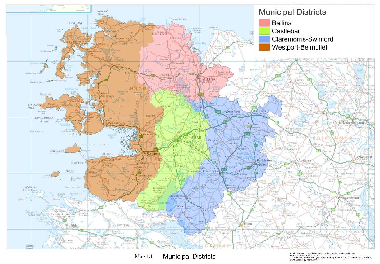
The Mayo County Development Plan 2021-2027 sets out the roadmap for the overall proper planning and sustainable development of County Mayo over the plan period. While the Plan is in place for a six-year period, it is framed having regard to the long-term development objectives of the county up until 2040, to align with national and regional spatial plans. The Plan governs the whole functional area of Mayo County Council, including the former Town Council functional areas of Castlebar, Ballina and Westport. The Council operates through four Municipal Districts (MD) in the county, which include Ballina MD; Castlebar MD; Claremorris-Swinford MD and Westport-Belmullet MD (see Map 1.1).
The Plan, when adopted, will replace the Mayo County Development Plan 2014-2020. This plan provides for, and manages, the physical, economic, and social development of the County, in the interests of the overall common good, and in compliance with environmental legislation. It includes a set of development objectives and standards, which set out where land is to be developed, and for what purposes (e.g. housing, retail, education, schools, employment, open space, amenity, conservation etc). It informs decisions on where public services such as roads and water infrastructure are to be provided and affects the type of buildings that can be constructed and how land is utilised. It influences many facets of daily economic and social life, in terms of where people can live, what services and facilities are available and where job opportunities are to be sited.
1.2 Profile of County Mayo
County Mayo is located on the west coast of Ireland in the province of Connacht. The county stretches from Lough Corrib and Killary Harbour in the south to the barony of Erris and Killala Bay in the north, and from the Atlantic Ocean on the west coast to the counties of Sligo and Roscommon on the east. Mayo is the third-largest county in area in the state and the second largest county in Connacht, in terms of size and population. Mayo has a population of 130,507, Castlebar being the largest town has a population of just over 12,000, followed by Ballina (10,171), Westport (6,198), Claremorris (3,687) and Ballinrobe (2,786). Over 71% of people in Mayo live in rural areas.
There is a distinct geological difference between the west and the east of the county. The west consists of large areas of extensive Atlantic blanket bog, whereas the east is largely a limestone landscape.
- Mayo has the longest coastline in Ireland, at 1,168 km or approximately 21% of the total coastline of the State.
- The highest point in Mayo (and Connacht) is Mweelrea, at 814 m (2,671 ft).
- The River Moy in the northeast of the county is renowned for its salmon fishing.
- Ireland's largest island, Achill Island, lies off Mayo's west coast.
- Mayo has Ireland's highest cliffs at Croaghaun, Achill Island, while the Benwee Head cliffs in Kilcommon Erris drop almost perpendicularly 900 feet (270 m) into the Atlantic Ocean.
- The northwest areas of County Mayo have some of the best renewable energy resources in Europe, if not the world, in terms of wind resources, ocean wave, tidal and hydroelectric resources.
The county possesses a strong community identity and a rich and diverse cultural heritage. Mayo’s Gaeltacht region, comprising of three distinct areas (Erris, Achill Island and Tourmakeady), is the third largest in Ireland with 10,886 inhabitants, representing 11.5% of the total Gaeltacht population in the state. Significant progress continues to be made in the improvement of physical, social and community infrastructure in the towns and villages throughout the county, as it is recognised that social infrastructure and community development supports economic growth, provides employment opportunities and improves the well-being and quality of life for the people of Mayo.
The county contains an extensive national road network and rail network, which connects the towns of Ballina, Castlebar, Westport, Claremorris, Ballyhaunis and Foxford. The county also contains Ireland West Airport Knock. The airport provides an international gateway to the west region, and its Strategic Development Zone (SDZ) has the potential to become a major enterprise and employment hub within the Atlantic Economic Corridor.
1.3 Strategic Context
The Plan builds on the review of the 2014-2020 County Development Plan and is required to set out a strategy for the growth and development of County Mayo, consistent with national and regional spatial plans. The Plan must also have regard or be consistent with national development guidelines, local strategies and programmes, and must comply with both planning and environmental legislation. Since the adoption of the Mayo County Development Plan 2014-2020, significant changes have occurred in the policy and regulatory environment for land use planning in Ireland. A new national and regional hierarchy of plans are now in place.
Project Ireland 2040, which includes the National Planning Framework (NPF) and National Development Plan (NDP), sets out the Government’s policy on spatial planning over the period to 2040. The NPF influences all spatial plans from national to local levels. The Regional Spatial and Economic Strategy (RSES) sets out the mechanism for delivering the NPF at a regional level. The County Development Plan will provide an overall strategy for development for the county, whilst local area plans provide more detailed planning guidance for urban areas over 5,000 populations.
1.3.1 The National Planning Framework
The NPF is a high-level strategy that provides the sustainable framework to guide where development and investment occurs in Ireland up until 2040. The NPF is centred around ten national policy objectives called National Strategic Outcomes (NSOs) (see Figure 1.1 below). Regional and local plans must align with these NSOs, which are underpinned by 75 national policy objectives (NPOs). The preparation of the County Development Plan has been informed by these NSOs and related NPOs. The NSOs emphasise that regional and international connectivity will contribute to the development of a strong economy. The top priority of the NPF is sustainable growth of compact cities, towns and villages.
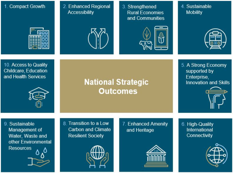
Figure 1.1: National Strategic Objectives of the NPF Source: Project 2040.
1.3.2 Regional Spatial and Economic Strategy (RSES)
The RSES is a strategic plan to support implementation of Project Ireland 2040 (NPF and NDP) and the economic policies and objectives of the Government, by providing a long-term strategic planning and economic framework for the development of the region. The adopted RSES (2020-2032) for the Northern and Western Region identifies regional assets, opportunities and pressures and provides appropriate policy responses in the form of Regional Policy Objectives (RPOs). Development plans for counties within the Northern and Western Regional Assembly (NWRA) area must align with this RSES.
At a strategic level, the RSES provides a framework for investment to better manage spatial planning and economic development to sustainably grow the Region to 2032 and beyond. It aims to transform the region with a new, focused approach to the delivery of housing, enterprise, infrastructure, healthcare, education and childcare, while also developing more employment clusters in high-value sectors such as tech, advanced engineering, food and medtech.
The NWRA RSES provides for a growth framework to transform the region based on 5 Growth Ambitions:
- Vibrant Ambition - Economy and Employment
- Natural Ambition - Environment
- Connected Ambition - Connectivity
- Inclusive Ambition - Quality of Life
- Enabling Ambition - Infrastructure
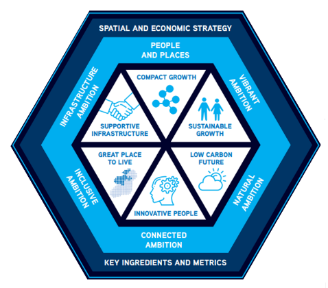
Figure 1.2: Five Growth Ambitions of the RSES Source: NWRA RSES 2020-2032
Figure 1.2 above illustrates these growth ambitions with associated guiding principles, aligned with the NPF’s strategic objectives, such as compact growth, sustainable growth, supportive infrastructure, place-making and a low carbon future.
The RSES identities the large urban areas as key economic drivers for the region, and at county level. In Mayo, the RSES identifies strategic roles for Castlebar and Ballina, as designated Key Towns, and Westport, as a town with strategic development potential of a regional scale intrinsically linked to Castlebar.
1.3.3 Mayo County Development Plan 2021-2027
In order to achieve the outcomes of the NPF and RSES, the Mayo County Development Plan 2021 – 2027 is considered the first of three development plans to 2040. Figure 1.3 below shows how the Plan fits in the nationally, regionally and locally context.
The intention of this plan is to build on the development foundations already established in Mayo and to ‘plant seeds’ throughout to stimulate growth. With the implementation of a comprehensive monitoring regime, the second of the three development plans will provide adjustments and policy interventions that are necessary to re-align with both the NPF and RSES, but will also see necessary adjustments to align with the National Marine Planning Framework. The third development plan will build on previous two plans and may require further adjustments and policy intervention to ensure alignments with the NPF and RSES.
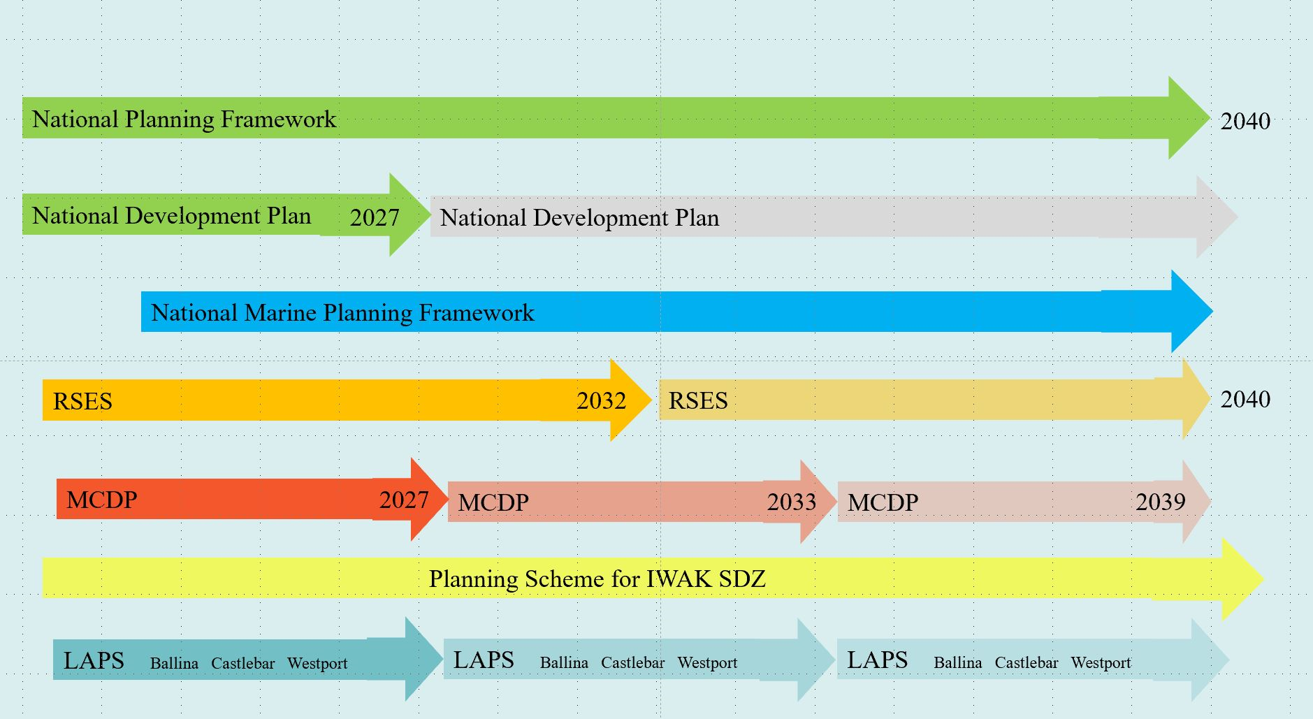
Figure 1.3: Showing Context of Plan, Nationally, Regionally and Locally
1.4 UN Sustainable Development Goals
There is significant alignment between the NPF, the RSES and the UN Sustainable Development Goals (SDGs). These Goals also act as a foundation for the Mayo County Development Plan, 2021-2027. There are 17 Sustainable Development Goals (SDGs) set by the UN General Assembly in 2015 as a blueprint to achieve better and more sustainable development for all. The NPF states: “sustainability is at the heart of long-term planning and the NPF seeks to ensure that decisions we take today meet our own needs without compromising the ability of future generations to meet their needs”. Development Plan objectives can have a direct impact on achieving the SDGs, such as Sustainable Communities and Climate Action and have an indirect impact on the achievement of many other SDGs. The strategic aims and development objectives in the Plan are therefore proofed against the SDGs.
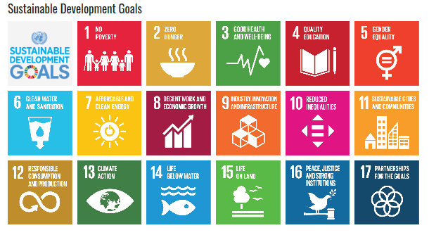
Figure 1.4: United Nations Sustainable Development Goals
1.5 Climate Action
Climate change impacts are currently experienced worldwide. Coastal areas in western parts of Europe, such as Ireland, can expect more heavy rain, higher risk of flooding from rivers and higher risk of storms in winter. County Mayo is particularly vulnerable to river, coastal/tidal flooding, drought, colder winters as well as surface water flooding arising from heavy rain. The national Climate Action Plan (2019) sets out a course of action to address the impacts of climate change on Ireland’s environment, society, economic and natural resources. The Climate Action Plan identifies the scale of the challenge and examines impacts on a range of key sectors including Electricity, Transport, Built Environment, Industry and Agriculture and charts a course towards ambitious emission reduction targets. Mayo County Council has adopted and is implementing a Climate Adaptation Strategy for the county and will also deliver a Climate Action Plan. Climate change is an integral theme of the Development Plan.
1.6 Planning Guidelines
The Minister for Housing, Local Government and Heritage, issues statutory guidelines from time to time, to planning authorities, who must have regard to them in carrying out their functions, including in the preparation of the County Development Plan. They cover a wide range of issues including architectural heritage, childcare facilities, landscape, residential density and design, environmental assessment and development management. Where planning guidance documents contain Specific Planning Policy Requirements (SPPR), such as in the Interim Guidelines on Statutory Plans, Renewable Energy and Climate Change (2017), the Apartment Guidelines (2018) and Building Height Guidelines (2018), local authorities are required to be consistent with these documents.
1.7 Preparation of the Development Plan and the Legislative Context
The preparation of the Development Plan has been influenced by a number of strategic international, national, regional and local policy documents, guidelines, strategies and legislation. Figure 1.5 below illustrates the Irish hierarchy of plans and demonstrates how EU and national legislation and policy, as well as local input, will feed into the preparation of the County Development Plan.
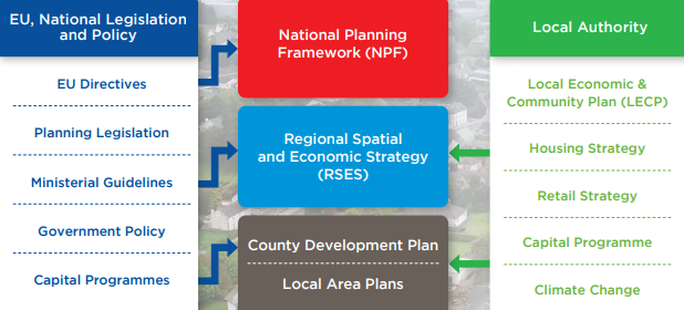
Figure 1.5: Irish Hierarchy of Plans and EU and National Legislation and Policy
The Plan must also have regard to the Development Plans of adjoining Local Authorities, which include Galway, Sligo and Roscommon. Development plans must comply with the requirements of the Planning and Development Act 2000 (as amended), in particular Sections 9, 10, 11 and 12. Development plans must be consistent, as far as is practicable, with national plans, policies or strategies that the Minister for Housing, Local Government and Heritage determines relate to proper planning and sustainable development. Section 10(2) of the Planning and Development Acts 2000 (as amended) requires development plans to include mandatory development objectives relating to zoning of lands, provision of infrastructure, conservation and protection of the environment, management of features and preservation of the landscape, etc. The County Development Plan accords with planning legislative requirements.
1.8 Environmental Reports
The County Development Plan has also been informed by the preparation of three Environmental Assessments, in tandem with the plan making process. In accordance with European and National legislation, the Council has carried out a Strategic Environmental Assessment (SEA) and an Appropriate Assessment (AA) under the SEA Directive and Habitats Directive. These assessments are undertaken in order to ensure that the potential impacts of the objectives contained in the Plan on the environment can be evaluated. This process informs the content of the plan and ensures that development responds appropriately to the sensitivities and requirements of the wider natural environment. A Strategic Flood Risk Assessment (SFRA) has also been undertaken for the plan area. This provides a broad assessment of flood risk within the county and will inform strategic land use planning decisions in this and other local plans. It is considered that the development objectives in the Plan are consistent, in as far as practicable, with the conservation and protection of the environment.
1.8.1 Strategic Environmental Assessment (SEA)
The Plan was subject to a Strategic Environmental Assessment (SEA), as required under the Planning and Development (Strategic Environmental Assessment) Regulations 2004. SEA is the formal, systematic evaluation of the likely significant environmental effects of implementing a plan or programme before the decision is made to adopt the plan or programme. The findings of the SEA process are included in the SEA Environmental Report that accompanies the Development Plan. The outcomes of the SEA process have been fully incorporated into the preparation and making of this Plan. The Environmental Report has been published as a separate document in conjunction with this Plan and is included in Volume 5.
1.8.2 Appropriate Assessment (AA)
Article 6(3) of European Council Directive 92/43/ EEC on the conservation of natural habitats and of wild fauna and flora (the Habitats Directive) requires Competent Authorities, in this case Mayo County Council, to undertake an Appropriate Assessment of any plan or project not directly connected with or necessary to the management of a Natura 2000 site, but likely to have a significant effect thereon, either individually or in combination with other plans or projects. The assessment examines the implications of proceeding with the plan or project in view of the relevant European site’s conservation objectives. All AA recommendations have been integrated into the Plan. The emerging conclusion of the AA is that the Plan will not adversely affect the integrity of European Sites, in light of their conservation objectives. A Natura Impact Report has been published as a separate document in conjunction with this Plan and is included in Volume 5.
1.8.3 Strategic Flood Risk Assessment (SFRA)
Strategic Flood Risk Assessment (SFRA) is an assessment of flood risk and includes mapped boundaries for indicative flood risk zones, taking into account factors such as local knowledge, site walkovers and flood risk indicators. SFRA is required under ‘The Planning System and Flood Risk Management Guidelines for Planning Authorities’ (Department of Environment and Office of Public Works, 2009) and the associated Department of the Environment, Community and Local Government Circular PL2/2014. All SFRA recommendations have been integrated into the Plan. The Strategic Flood Risk Assessment has been published as a separate document in conjunction with this Plan and is included in Volume 5.
1.9 Format of the County Development Plan
The Plan consists of 6 volumes. Volume 1 consists of a written statement and maps. The written statement comprises of 12 chapters. Chapters 2 to 12, inclusive, include an overarching strategic aim and a set of development objectives to achieve the strategic aim. The maps provide a graphic representation of the key elements of the Plan. Volume 1 is set out as follows:
|
Chapter 1 |
INTRODUCTION |
|
Chapter 2 |
CORE AND SETTLEMENT STRATEGY |
|
Chapter 3 |
HOUSING |
|
Chapter 4 |
ECONOMIC DEVELOPMENT |
|
Chapter 5 |
TOURISM DEVELOPMENT |
|
Chapter 6 |
MOVEMENT AND TRANSPORT |
|
Chapter 7 |
INFRASTRUCTURE |
|
Chapter 8 |
SUSTAINABLE COMMUNITIES |
|
Chapter 9 |
BUILT ENVIRONMENT |
|
Chapter 10 |
NATURAL ENVIRONMENT |
|
Chapter 11 |
CLIMATE ACTION AND RENEWABLE ENERGY |
|
Chapter 12 |
SETTLEMENT PLANS |
Volume 2 contains the Development Management Standards. The aim of this guidance document is to assist those wishing to develop in the county by outlining what will be required when applying for planning permission. The guidance document is based on the objectives in the Plan, government policy, planning guidance documents and established best practice.
Volume 3 includes the Book of Maps for Settlement Plans.
Volume 4 includes Supporting Documents such as the Mayo Renewable Energy Strategy; Mayo Housing Strategy; Landscape Appraisal for County Mayo; Mayo Rural Housing Design Guidelines 2008, Design and Record of Protected Structures.
Volume 5 includes all 3 Environmental Reports (SFRA, SEA and NIR) undertaken in the preparation of the plan.
Volume 6 includes the Ireland West Airport Knock (IWAK) Planning Scheme for the Strategic Development Zone.
Appendices includes the (I) Settlement Assets Capacity Matrix , (II) Municipal District Projects and (III) Key Documents Table.
1.10 Statement Outlining Compliance with Section 28 Guidelines
Pursuant to Section 28 of the Planning and Development Act 2000 (as amended), Mayo County Council is required to append a statement to the Mayo County Development Plan 2021-2027 to include information which demonstrates the following:
- How the planning authority has implemented the policies and objectives of the Minister contained in the guidelines when considering their application to the area or part of the area of the Development Plan, or
- If applicable, that the planning authority has formed the opinion that it is not possible, because of the nature and characteristics of the area or part of the area of the development plan, to implement certain policies and objectives of the Minister contained in the guidelines when considering the application of those policies in the area or part of the area of the development plan and shall give reasons for the forming of the opinion and why policies and objectives of the Minister have not been so implemented.
The following table demonstrates how the Mayo County Development Plan 2021-2027 implements applicable Ministerial Planning Guidelines issued under Section 28 of the Act.
Table 1.1 - Implementation of Section 28 Ministerial Planning Guidelines
|
Section 28 Guidelines |
Draft Mayo County Development Plan 2021-2027 |
|
Appropriate Assessment of Plans and Projects in Ireland – Guidance for Planning Authorities (2009) |
The preparation of the Plan has had regard to this guidance document. A Natura Impact Report has been prepared and accompanies the Plan. |
|
Strategic Environmental Assessment (SEA) Guidelines (2004) |
The preparation of the Plan has had regard to these Guidelines. Strategic Environmental Assessment was initiated with the preparation of a SEA Environmental Report accompanying this Plan. |
|
Architectural Heritage Protection – Guidelines for Planning Authorities (2004), and as updated (2011) |
Chapter 9 (Built Environment) and Chapter 10 (Natural Environment) addresses the natural and built heritage, and conservation. Policies and objectives contained within this Plan have had regard to various legislative provisions and policy guidance documents, including, the Planning and Development Act 2000 (as amended), Architectural Heritage Protection – Guidelines for Planning Authorities 2004, (as updated 2011). The Plan provides policies and objectives relating to the protection and conservation of the Architectural and Archaeological Heritage. It is accompanied by a Record of Protected Structures. The Plan includes an objective to investigate the feasibility of designating additional Architectural Conservation Areas during the Plan period |
|
Implementing Regional Planning Guidelines – Best Practice Guidance (2010) |
Chapter 2 (Core and Settlement Strategy) sets out policies and objectives to ensure that the Core Strategy requirements of the Plan are consistent with national and regional policy (National Planning Framework 2018, Regional Spatial and Economic Strategy for the Northern and Western Region 2020), as required by the 2010 Guidance document. |
|
Childcare Facilities: Guidelines for Planning Authorities (2001) And as updated by Circular letter PL3/2016 (2016) |
Chapter 8 (Sustainable Communities), Chapter 12 (Settlement Plans) and Volume 2 (Development Management Standards) addresses the issue of childcare facilities. Chapter 8 includes policies which set out the most appropriate locations for childcare facilities in addition to policies which have regard to the recommendations and requirements of the Childcare Facilities: Guidelines for Planning Authorities (2001). Volume 2 (development management standards) set out details regarding the provision of childcare facilities and advises that planning applications will be considered having regard to compliance with the Childcare Facilities Guidelines. |
|
Development Management Guidelines (2007) |
Volume 2 Development Management Standards has been prepared having reference to the Development Management Guidelines. |
|
Development Plan – Guidelines for Planning Authorities (2007)
|
The Development Plan Guidelines for Planning Authorities have informed the preparation of this Development Plan. The Plan also sets out the planning framework for the future development of each of the settlements and rural areas which is informed by national and regional planning policy. |
|
Quarries and Ancillary Activities (2004)
|
Chapter 4 Economic Development and Chapter 10 Natural Environment set out the policies and objectives for the extractive industry. Volume 2 (Development Management Standards) refers to the Guidelines and identifies the issues to be addressed in development proposals for quarries. |
|
Provision of Schools and the Planning System (2008) |
Policies and objectives contained in Chapter 8 (Sustainable Communities) address education provision in the county. |
|
Retail Planning Guidelines (2012) |
Chapter 4 (Economic Development) refers to the Guidelines and sets out the retail policies and objectives of the Development Plan. |
|
Sustainable Rural Housing Guidelines (2005) |
Chapter 3 (Housing) sets out the rural housing policies and objectives for County Mayo. These policies and objectives incorporate the recommendations of the guidelines. |
|
Sustainable Residential Development in Urban Areas (2009)
|
The Guidelines have been considered in the context of Volume 2 Development Management Standards, Chapter 2 (Core & Settlement Strategy), Chapter 3 (Housing), Chapter 9 (Built Environment) and Chapter 12 (Settlement Plans), to encourage the provision of high- quality design and density in the settlement areas of County Mayo. |
|
The Planning System and Flood Risk Management – Guidelines for Planning Authorities (2009) |
A Strategic Flood Risk Assessment (SFRA) has been carried out for County Mayo having regard to the Guidelines. The SFRA document accompanies the Plan and identifies areas of flood risk by reference to data available from a number of sources. Policies and objectives in relation to flood risk are included in Chapter 7 (Infrastructure). |
|
Spatial Planning and National Roads Guidelines (2012) |
Chapter 6 (Movement and Transport) contains a specific policy which restricts development affecting national primary and secondary roads, outside urban speed limits in accordance with the 2012 Guidelines. |
|
Wind Energy Development Guidelines (2006)
|
Chapter 11 (Climate Action and Renewable Energy) has been formulated having regard to the Wind Energy Guidelines. Chapter 11 of the Plan contains a positive supporting statement. The Renewable Energy Strategy includes maps, which identify locations open for consideration for wind energy development. In addition, Volume 2 Development Management Standards requires all planning applications for wind energy turbines or wind farms be assessed against the Wind Energy Guidelines. |
|
Development Contribution Schemes – Guidelines for Planning Authorities (2013)
|
Volume 2 (Development Management Standards) refers to the Guidelines, which is designed to assist planning authorities to achieve, through their development contribution schemes, a balance between the costs of the services provided and the need to support economic activity and renewal. |
|
National Landscape Strategy for Ireland 2015-2025
|
Chapter 10 (Natural Environment) notes the National Landscape Strategy for Ireland 2015-2025, which recognises the importance of landscape protection and its interconnectivity with biodiversity and climate change. It identifies the need for national and regional landscape character assessments to provide a framework for comprehensive and consistent local (county) landscape character assessments. Once the necessary national and regional landscape character assessments and maps are in place, in addition to guidance on local landscape character assessments, the Council will review the Landscape Appraisal of County Mayo to ensure a consistent approach. |
|
Sustainable Urban Housing Design Standards for New Apartments (2015) (as updated (2018). |
Chapter 3 (Housing) and Volume 2 (Development Management Standards) refers to these Guidelines which provides guidance including specific planning policy requirements on apartment developments. |
|
Guidance Note on Core Strategies (2010)
|
Chapter 2 (Core & Settlement Strategy), states that the Core Strategy has been guided by the content of these guidelines and in particular the provision of the Core Strategy Table and Core Strategy Settlement Map |
|
Design Manual for Urban Roads and Streets (2013) (as updated in 2019) |
Chapter 6 (Movement and Transport) and Volume 2 (Development Management Standards) address these Guidelines and how they provide practical design measures to encourage more sustainable travel patterns in urban areas and best practice in the design of street networks and individual streets. |
|
Urban Development and Building Heights – Guidelines for Planning Authorities (2018)
|
Chapter 3 (Housing), Chapter 9 (Built Environment) and Chapter 12 (Settlement Plans) and Volume 2 (Development Management Standards) addresses types of sites that could be considered for taller buildings.
|
|
Tree Preservation – Guidelines for Planning Authorities
|
Chapter 10 (Natural Environment) states that the Council aims to protect individual trees, groups of trees or woodland, which are of environmental and/or amenity value. This can be done so with a Tree Preservation Order (TPO) that can be made through the development plan process or a separate TPO process under Section 205 of the Planning and Development Act 2000 (as amended). The existing Tree Preservation Orders are set out in the plan. |
|
Telecommunications Antennae and Support Structures – Guidelines for Planning Authorities |
Chapter 7 (Infrastructure) states that the Council recognises the importance of achieving a balance between facilitating the provision of telecommunications services in the interests of social and economic progress and protecting residential amenity and environmental quality. The Council will have regard to the Department of the Environment, Community and Local Governments Guidelines on Telecommunications Antennae and Support Structures and Circular Letter PL07/12 (Telecommunications Antennae and Support Structures) in assessing development proposals. |
|
Interim Guidelines for Planning Authorities on Statutory Plans, Renewable Energy and Climate Change (2017) |
Chapter 11 (Climate Action and Renewable Energy) states that renewable development has had regard to various national plans, policies and strategies that relate to renewable energy and climate change. |
|
Quality Housing for Sustainable Communities – Design Guidelines (2007) |
Volume 2 (Development Management Standards) has had regard to the Guidelines |
1.11 Implementation and Monitoring
Mayo County Council is fully committed to securing and monitoring the implementation of the strategies, policies and objectives of this Plan. The Council will continue to occupy a leadership role to progress and secure the Plan policies and objectives to achieve the sustainable development of the county. The successful implementation of a significant number of the policies and objectives of this Development Plan will necessitate on-going collaboration and a sense of good-will across a range of agencies and stakeholders. The implementation of this Plan will depend also on the economic climate, political support, Council funding and the availability of funding from other sources.
The Planning Department of the Council is the main section responsible for monitoring and implementing the Plan, mainly through the development management function. However, it is important to note that this Plan coordinates the work and objectives of other key departments within Mayo County Council, such as Local Economic Office (LEO). In some cases, the body responsible for the implementation of certain Plan objectives may be external, such as Irish Water, National Parks and Wildlife Service, Waterways Ireland, Transport Infrastructure Ireland, and the Environmental Protection Agency.
The Planning and Development (Amendment) Act 2018 established the legal basis for the Office of the Planning Regulator and outlines its role and functions, which include the assessment of all local authority forward planning programmes. It operates an independent monitoring role, advising Government on implementation of local authority statutory planning processes.
Under the provisions of Section 15 of the Planning and Development Act 2000 (as amended), the Council has a statutory obligation to secure the implementation of the objectives of the Plan and to prepare a progress report on achieving the objectives not more than 2 years after the making of this Plan. Additionally, under Section 22A (2) of the Planning and Development Act 2000 (as amended), each Local Authority within the Regional Assembly is required, every 2 years, to prepare and submit a report to the Assembly setting out progress made in supporting objectives, relevant to that authority, contained in the RSES.
As far as practicable, every effort has been made to formulate objectives that are specific, measurable, achievable and realistic. Some sources of funding that will help in achieving the delivery of objectives within the Plan include:
- Public Private Partnerships
- Urban Regeneration and Development Fund
- Rural Regeneration and Development Fund
- Climate Action Fund
- Disruptive Technologies Fund
- Development Contributions
1.12 Interpretation
In interpreting this document in all cases should any conflict arise between the written word and accompanying maps the written word shall take precedence.
1.12.1 Protocols
In all cases the following protocols apply:
- The Council refers to Mayo County Council.
- The Plan refers to the County Development Plan 2021-2027.
- The County refers to County Mayo.
Contents
Observations
Observations
Submission on behalf of Tesco Ireland on the Draft Mayo County Development Plan 2021-2027
Please find attached a submission on behalf of Tesco Ireland on the Draft Mayo County Development Plan 2021-2027
Full submission
Pease see atached document including Moy Estuary Study 2020
Linking Sustainable Development Goals
1.4 UN Sustainable Development Goals
We note the inclusion of the alignment between the NPF, the RSES and the UN Sustainable Development Goals (SDGs). Mayo Dark Skies aligns...